
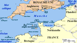
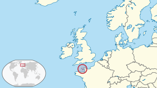
The Channel Islands are an archipelago in the English Channel, off the French coast of Normandy. They are divided into two Crown Dependencies: the Bailiwick of Jersey, which is the largest of the islands; and the Bailiwick of Guernsey, consisting of Guernsey, Alderney, Sark, Herm and some smaller islands. Historically, they are the remnants of the Duchy of Normandy. Although they are not part of the United Kingdom, the UK is currently responsible for the defence and international relations of the islands. The Crown Dependencies are neither members of the Commonwealth of Nations, nor part of the European Union. They have a total population of about 171,916, and the bailiwicks' capitals, Saint Helier and Saint Peter Port, have populations of 33,500 and 18,207 respectively.
Guernsey is the second largest island in the Channel Islands, located 27 miles (43 km) west of the Cotentin Peninsula, Normandy. It forms the major part of the jurisdiction of the same name, which also comprises three other inhabited islands and many small islets and rocks. The jurisdiction has a population of 63,950 and the island has a land area of 24 square miles (62 km2).

The history of Guernsey stretches back with evidence of Neolithic occupation, followed by Roman occupation. Christianity was brought to Guernsey by St Sampson.

Normandy is a geographical and cultural region in northwestern Europe, roughly coextensive with the historical Duchy of Normandy.
Manche is a coastal French département in Normandy on the English Channel, which is known as La Manche, literally "the sleeve", in French. Manche is bordered by Ille-et-Vilaine and Mayenne to the south, Orne and Calvados to the east, as well it borders the English Channel to the west and north and by sharing maritime borders with the Crown Dependencies of Bailiwick of Jersey and Bailiwick of Guernsey of the United Kingdom to the west. It had a population of 495,045 in 2019.

Alderney is the northernmost of the inhabited Channel Islands. It is part of the Bailiwick of Guernsey, a British Crown dependency. It is 3 miles (5 km) long and 1+1⁄2 miles (2.4 km) wide.

Saint-Malo is a historic French port in Ille-et-Vilaine, Brittany.

The Cotentin Peninsula, also known as the Cherbourg Peninsula, is a peninsula in Normandy that forms part of the northwest coast of France. It extends north-westward into the English Channel, towards Great Britain. To its west lie the Gulf of Saint-Malo and the Channel Islands, and to the southwest lies the peninsula of Brittany.
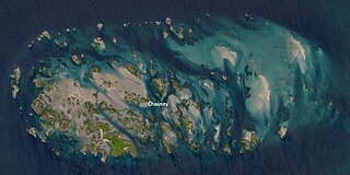
Chausey is a group of small islands, islets and rocks off the coast of Normandy, in the English Channel. It lies 17 kilometres (11 mi) from Granville and forms a quartier of the Granville commune in the Manche département. Chausey forms part of the Channel Islands from a geographical point of view, but, because it is under French jurisdiction, it is almost never mentioned in the context of the other Channel Islands. There are no scheduled transport links between Chausey and the other Channel Islands, although between two and four daily shuttles link Chausey to mainland France through Granville, depending on the season.

The Bailiwick of Guernsey is a self-governing British Crown Dependency off the coast of Normandy, France, comprising several of the Channel Islands. It has a total land area of 78 square kilometres (30 sq mi) and an estimated total population of 67,334.

A tidal island is a raised area of land within a waterbody, which is connected to the larger mainland by a natural isthmus or man-made causeway that is exposed at low tide and submerged at high tide, making the land switching between a promontory/peninsula and an island depending on tidal conditions.

The Alderney is an extinct breed of dairy cattle. It originated in, and is named for, the island of Alderney in the Channel Islands. It was one of three breeds of Channel Island cattle, the others being the Jersey and the Guernsey. In the eighteenth and nineteenth centuries "Alderney" was a general term for cattle from the archipelago; many were exported to mainland Britain under this name, regardless of which of the islands they came from.
The Cadomian Orogeny was a tectonic event or series of events in the late Neoproterozoic, about 650–550 Ma, which probably included the formation of mountains. This occurred on the margin of the Gondwana continent, involving one or more collisions of island arcs and accretion of other material at a subduction zone. The precise events, and geographical position, are uncertain, but are thought to involve the terranes of Avalonia, Armorica and Iberia. Rocks deformed in the orogeny are found in several areas of Europe, including northern France, the English Midlands, southern Germany, Bohemia, southern Poland and the southwest Iberian Peninsula. The name comes from Cadomus, the Latin name for Caen, northern France. L Bertrand gave the orogeny its name in 1921, naming it after Cadomus the Gaulish name for Caen in Normandy. He defined the end as being marked by Lower Palaeozoic red beds.
The Baie de Seine is a bay in northern France.

Barneville-Carteret is a commune in the Manche department in the Normandy region of north-western France. For many years it has been a popular seaside resort destination.
The Leader of Alderney is the civil leader of Alderney. Alderney is a dependency of the Bailiwick of Guernsey. Its leader has traditionally been appointed by the British Crown and has been known by various titles including Lord of Alderney, Governor of Alderney, and the current President of the States of Alderney. The President of the States of Alderney is directly elected every four years and there is no constitutional limit to the number of terms served. The current president, William Tate has held the post since 2019.
The Alderney Race is a strait that runs between Alderney and Cap de la Hague, a cape at the northwestern tip of the Cotentin Peninsula in Normandy. A strong current runs through the race north of the Passage de la Déroute, a treacherous passage separating the Cotentin from the Channel Islands. The current is intermittent, varying with the tide, and can run up to about 12 knots during equinoctial tides. The French call it Raz Blanchard. In Norman French it is called L'Raz.
The history of the Jews in Guernsey dates back to well before the events of 1940–5. A London Jew named Abraham was described in 1277 as being from "La Gelnseye" (Guernsey). A converted Portuguese Jew, Edward Brampton, was appointed Governor of Guernsey in 1482.

Archaeology is promoted in Jersey by the Société Jersiaise and by Jersey Heritage. Promotion in the Bailiwick of Guernsey being undertaken by La Société Guernesiaise, Guernsey Museums, the Alderney Society with World War II work also undertaken by Festung Guernsey.
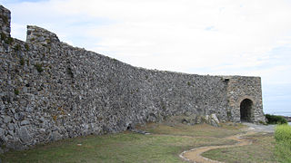
Vale Castle, is a protected building located in the Vale, Guernsey. The original name was "Le Chateau St Michel", later it became "Chateau de Val" or "Chateau de Valle" and is over 1,000 years old. It defends both St. Sampson's harbour at the eastern end of the Braye du Valle, Guernsey, and Bordeaux Harbour.
