
Herkimer County is a county in the U.S. state of New York. As of the 2020 census, the population was 60,139. Its county seat is Herkimer. The county was created in 1791 north of the Mohawk River out of part of Montgomery County. It is named after General Nicholas Herkimer, who died from battle wounds in 1777 after taking part in the Battle of Oriskany during the Revolutionary War. The county is part of the Mohawk Valley region of the state.

Otsego County is a county in the U.S. state of New York. As of the 2020 census, the population was 58,524. The county seat is Cooperstown. The county's population center is Oneonta. The name Otsego is from a Mohawk or Oneida word meaning "place of the rock." The county is part of the Mohawk Valley region of the state.
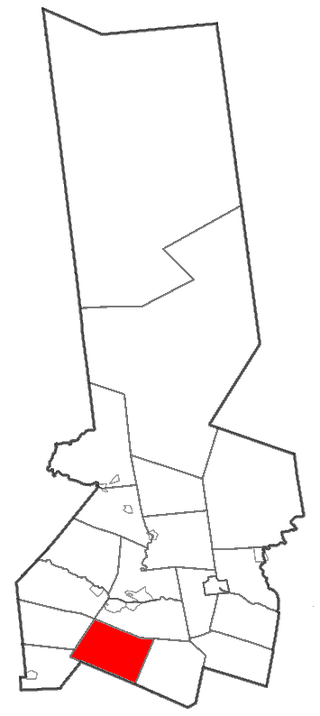
Columbia is a town in Herkimer County, New York, United States. As of the 2020 census, the town population was 1,569. The town is at the southern border of the county and is southeast of Utica.
Mohawk is a village in Herkimer County, New York, United States. The population was 2,731 at the 2010 census. The village was named after the adjacent Mohawk River.

Richfield is a town located in Otsego County, New York, United States. As of the 2010 census, the town had a population of 2,388. The Town of Richfield is located at the northern border of the county.

Richfield Springs is a village located in the Town of Richfield, on the north-central border of Otsego County, New York, United States. The population was 1,050 at the 2020 census. The name is derived from local sulfur springs.

Herkimer is a town in Herkimer County, New York, United States, southeast of Utica. It is named after Nicholas Herkimer. The population was 9,566 at the 2020 census, down from 10,175 in 2010.
Amsterdam is a city in Montgomery County, New York, United States. As of the 2020 census, the city had a population of 18,219. The city is named after Amsterdam in the Netherlands.
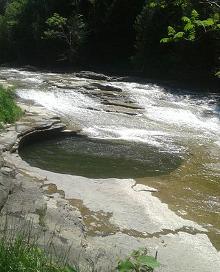
Canajoharie is a village in the Town of Canajoharie in Montgomery County, New York, United States. As of the 2010 census, the village had a population of 2,229. The name is said to be a Mohawk language term meaning "the pot that washes itself," referring to the "Canajoharie Boiling Pot," a circular gorge in the Canajoharie Creek, just south of the village.

Waterford is a town in Saratoga County, New York, United States. The population was 8,208 at the 2020 census. The name of the town is derived from its principal village, also called Waterford. The town is located in the southeast corner of Saratoga County and north-northwest of Troy at the junction of the Erie Canal and the Hudson River.

The Mohawk River is a 149-mile-long (240 km) river in the U.S. state of New York. It is the largest tributary of the Hudson River. The Mohawk flows into the Hudson in Cohoes, New York, a few miles north of the state capital of Albany. The river is named for the Mohawk Nation of the Iroquois Confederacy. A major waterway, in the early 19th century, the river's east-west valley provided the setting and water for development of the Erie Canal, as a key to developing New York. The largest tributary, the Schoharie Creek, accounts for over one quarter (26.83%) of the Mohawk River's watershed. Another main tributary is the West Canada Creek, which makes up for 16.33% of the Mohawk's watershed.

Otsego Lake is a 4,046-acre (16.37 km2) lake located in Otsego County in the U.S. state of New York. It is the source of the Susquehanna River and largest lake in Otsego County. The Village of Cooperstown is located at the lake's southern end. Glimmerglass State Park is located on the lake's northeastern shore, and includes Hyde Hall, a large mansion constructed in 1817, that overlooks the lake. The Glimmerglass Opera, opened in June 1987, is located on the western shore.
Schuyler Lake is the name of a small hamlet in the town of Exeter in Otsego County, New York, United States. It lies at the south end of Canadarago Lake and south of Richfield Springs. It is also known as Kaniatarake, which is a Mohawk name that translates to "on the lake".

Canadarago Lake is a 1,917-acre (7.76 km2) lake located in Otsego County, New York and is the source of Oaks Creek. The Village of Richfield Springs is located at the lake's northern end. It is the second largest lake in Otsego County, lying to the west of and parallel to the larger Otsego Lake. The lake's name is also spelled "Candajarago Lake" or "Caniadaraga Lake".

New York State Route 167 (NY 167) is a north–south state highway in the Mohawk Valley region of New York in the United States. It extends for 26.17 miles (42.12 km) from an intersection with U.S. Route 20 (US 20) in the Otsego County village of Richfield Springs to a junction with NY 29 in the Herkimer County village of Dolgeville. Midway between the two endpoints, NY 167 passes through the city of Little Falls, where it meets NY 5 and indirectly connects to the New York State Thruway by way of NY 169. Most of NY 167 is a two-lane rural highway; however, in Little Falls, NY 167 ranges in width from two to four lanes as it serves commercial and industrial sections of the city.

Federal Corners is a former hamlet located in the Town of Richfield, New York, in Otsego County, United States, approximately 1.5 miles southeast of the village of Richfield Springs, at the corner of Butternut Road and Cemetery Road.

The Canajoharie Creek is a river that flows into the Mohawk River in the Village of Canajoharie in the U.S. State of New York. The name "Canajoharie" is a Mohawk language term meaning "the pot that washes itself", referring to the "Canajoharie Boiling Pot", a 20-foot (6.1 m) wide and 10-foot (3.0 m) deep pothole in the Canajoharie Creek, just south of the village of Canajoharie. Bowmans Creek is one main tributary that enters the creek east of the Hamlet of Sprout Brook. The other main tributary is Brimstone Creek which enters the creek north-northwest of the Village of Ames.

Steele Creek is a river in Herkimer County in the state of New York. The creek begins in an unnamed swamp south of Cedarville, and flows in a northeast direction before emptying into the Mohawk River in the village of Ilion. Steele Creek travels through the Ilion Gorge and alongside NY-51 for most of its length. Steele Creek derives its name from Rudolph Stahl, who built the first grist mill in Ilion along the creek.
Sunset Hill is a mountain in the Central New York Region of New York. It is located in the towns of Richfield and Warren, north of Richfield Springs. It was formally called Abbott's Hill, as it was the site of Aaron Abbott's home and also Butternut Hill, from the big butternut trees that once stood on the hill.
Mohawk Hill is a hamlet in the town of West Turin in Lewis County, New York, United States. It is located on New York State Route 26, southwest of the village of Constableville.

