Related Research Articles

Banten is the westernmost province on the island of Java, Indonesia. Its capital city is Serang. The province borders West Java and the Special Capital Region of Jakarta on the east, the Java Sea on the north, the Indian Ocean on the south, and the Sunda Strait on the west. The province covers an area of 9,662.82 km2 (3,730.84 sq mi). It had a population of over 11.9 million in the 2020 census, up from about 10.6 million in 2010. The estimated mid-2021 population was 12.06 million. Formerly part of the province of West Java, Banten was declared a separate province in 2000. The region is the homeland of the Sundanese Banten people, whose culture differs slightly from that of West Java's Sundanese people. The northern half has recently experienced rapid rises in population and urbanization, and the southern half has a more traditional character.
The Special Region of Yogyakarta is a provincial-level autonomous region of Indonesia in southern Java. It has also been known as the Special Territory of Yogyakarta.

East Java is a province of Indonesia located in the easternmost hemisphere of Java island. It has a land border only with the province of Central Java to the west; the Java Sea and the Indian Ocean border its northern and southern coasts, respectively, while the narrow Bali Strait to the east separates Java from Bali. Located in eastern Java, the province also includes the island of Madura, as well as the Kangean islands and other smaller island groups located further east and Masalembu archipelagos in the north. Its capital is Surabaya, the second largest city in Indonesia, a major industrial center and also a major business center. Banyuwangi is the largest regency in East Java and the largest on the island of Java.

Central Java is a province of Indonesia, located in the middle of the island of Java. Its administrative capital is Semarang. It is bordered by West Java in the west, the Indian Ocean and the Special Region of Yogyakarta in the south, East Java in the east, and the Java Sea in the north. It has a total area of 32,800.69 km2, with a population of 36,516,035 at the 2020 Census making it the third-most populous province in both Java and Indonesia after West Java and East Java. The official estimate as at mid 2021 was 36,742,501. The province also includes the island of Nusakambangan in the south, and the Karimun Jawa Islands in the Java Sea.

Prambanan is a 9th-century Hindu temple compound in Special Region of Yogyakarta, Indonesia, dedicated to the Trimūrti, the expression of God as the Creator (Brahma), the Preserver (Vishnu) and the Destroyer (Shiva). The temple compound is located approximately 17 kilometres (11 mi) northeast of the city of Yogyakarta on the boundary between Central Java and Yogyakarta provinces.
Klaten Regency is a regency in Central Java province in Indonesia. It covers an area of 655.56 km2 and had a population of 1,130,047 at the 2010 Census and 1,260,506 at the 2020 Census. Its capital is the town of the same name.

Sleman Regency is an Indonesian regency on the island of Java. It is located in the north of the Yogyakarta Special Administrative Region, Indonesia, and has an area of 574.82 square kilometres (221.94 sq mi), with a population of 1,093,110 at the 2010 Census and 1,125,804 at the 2020 Census. Its capital is the town of Sleman. The current regent is Kustini Sri Purnomo.
Wonogiri Regency is a regency in the southeastern part of Central Java province in Indonesia. It covers an area of 1,822.36 km2, and its population was 928,904 at the 2010 Census and 1,096,138 at the 2020 Census. The capital and largest town is Wonogiri, around 33 km southeast of the large Central Java metropolis of Surakarta.
Tasikmalaya Regency is a regency in the province of West Java, Indonesia. It covers an area of 2,708.82 km2, and had a population of 1,687,776 at the 2010 census, which rose to 1,865,203 at the 2020 census. Located in the southeastern region of Priangan (Preanger), the regency is by far the biggest and the most important regency in East Preanger. The regency was previously administered from Tasikmalaya City, which however is now administratively independent of the regency, and the administrative centre of the regency is now at Singaparna to the west of the city.

A candi is a Hindu or Buddhist temple in Indonesia, mostly built during the Zaman Hindu-Buddha or "Hindu-Buddhist period" between circa the 4th and 15th centuries.

Kedu Plain, also known as Progo River valley, is the fertile volcanic plain that lies between the volcanoes Mount Sumbing and Mount Sundoro to the west, and Mount Merbabu and Mount Merapi to the east. It roughly corresponds to present-day Magelang and Temanggung Regency of Central Java, Indonesia.

Gunungkidul Regency is a regency in the southeast part of the province of Yogyakarta Special Region, Indonesia. It is located on the island of Java. The regency is bordered by the Sleman Regency to the north west, Bantul Regency to the west, the Indian Ocean to the south, Wonogiri Regency to the east and Klaten Regency to the north. It covers an area of 1,485.36 km2 and had a population of 675,382 at the 2010 Census and 747,161 at the 2020 Census.

Kewu Plain, also known as Prambanan Plain or Opak River valley, is a fertile volcanic plain that lies between Merapi-Merbabu complex in the north, Bantul lowlands and Sewu karst limestone range in the south, Bengawan Solo river valley in the east, the Progo River in the west, and Kedu Plain on northwest. It is located within the Yogyakarta Special Region, Sleman Regency, Klaten Regency and Solo City, Indonesia.

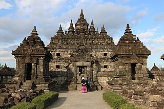
Banyunibo is a 9th-century Buddhist temple located in Cepit hamlet, Bokoharjo village, Prambanan, Sleman Regency, Special Region of Yogyakarta, Indonesia. The temple, dating from the era of Medang Kingdom, sits in a narrow valley surrounded by paddy fields about two kilometers southeast of the Ratu Boko archaeological park on the east side of modern Yogyakarta. Further north is the Prambanan temple, and to the south are the Gunung Sewu hills, extension of Gunung Kidul hills.

Maros Regency is a regency of South Sulawesi province of Indonesia. It covers an area of 1,619.12 sq.km, and had a population of 319,002 at the 2010 Census and 391,774 at the Census of 2020. The official estimate for mid 2021 was 396,924. Almost all of the regency lies within the official metropolitan area of the city of Makassar. The capital town of the regency is Maros.

Lumajang Regency is a Regency (kabupaten) located in the East Java province of Indonesia. It covers an area of 1,790.90 sq. km, and had a population of 1,006,458 at the 2010 Census and 1,119,251 at the 2020 Census. It shares its land borders with Jember Regency, Probolinggo Regency, and Malang Regency, while it borders the Indian Ocean to the south.
The derivation of the term geoheritage is from geological heritage. It is thus a heritage category comparable to other forms of natural heritage, such as biodiversity. Some geoheritage sites, or geosites, are related to human activity such as mining, and can also be viewed in terms of cultural heritage.

The archaeology of Indonesia is the study of the archaeology of the archipelagic realm that today forms the nation of Indonesia, stretching from prehistory through almost two millennia of documented history. The ancient Indonesian archipelago was a geographical maritime bridge between the political and cultural centers of Ancient India and Imperial China, and is notable as a part of ancient Maritime Silk Road.
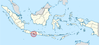
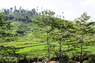
Gunung Sewu Geopark or Sewu Mountains is a series of mountains stretching along the southern coast of Gunung Kidul Regency and Wonogiri Regency of Central Java, to Tulungagung Regency of East Java in the island of Java, Indonesia. This is a national Geopark, which is also a member of Global Geopark Network (GGN), recognized by UNESCO in 2015.
References
- ↑ Despite the term 'mountain' they are hills in size, specially in comparison to the nearby volcanoes of Central Java
- 1 2 "April 8, 2012 - Karst Pegunungan Sewu".
- ↑ Truman Simanjuntak (editor) (2002) Gunung Sewu in prehistoric times. reader, John N. Miksic. Gadjah Mada University Press in Bulaksumur, Yogyakarta, Indonesia. ISBN 979-420-501-X
- ↑ "Indahnesia.com - Java island - Gunung Sewu - A paradise for cave explorers - Discover Indonesia Online". Archived from the original on 2010-10-31. Retrieved 2010-10-04.
- ↑ Stoddard, S. (1985). Anglo-Australian Speleological Expedition to Java. Cave Science, 12(2):49–60: Willis, R.G., Boothroyd, C. & Briggs, N. (1984). The caves of Gunung Sewu, Java. Cave Science, 11(3):119–53. Waltham, A.C., Smart, P.L., Friederich, H., Eavis, A.J. & Atkinson, T.C. (1983). The caves of Gunung Sewu, Java. Cave Science, 10(2):55–96
- ↑ Ida Ayu Made Sadnyari (September 20, 2015). "Susul Batur di Bali, Gunung Sewu Dinobatkan sebagai Geopark Kelas Dunia".
| | This Yogyakarta location article is a stub. You can help Wikipedia by expanding it. |