Belitung is an island on the east coast of Sumatra, Indonesia in the Java Sea. It covers 4,800.6 km2 (1,853.5 sq mi), and had a population of 309,097 at the 2020 Census. Administratively, it forms two regencies within the province of Bangka-Belitung Islands. The island is known for its pepper and for its tin. It was in the possession of the United Kingdom from 1812 until Britain ceded control of the island to the Netherlands in the Anglo-Dutch Treaty of 1824. Its main town is Tanjung Pandan. The United Nations Educational, Scientific and Cultural Organization has declared 17 tourist attractions in the Belitung Geopark as world geoparks.

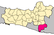
Garut Regency is a Regency in the West Java province of Indonesia. It covers an area of 3,065.19 km2 (1,186.91 mi2). Geographically, it lies between 6°57′34″ – 7°44′57″ South latitude and 107°24′34″ – 108°7′34″ East longitude. The population at the 2010 census was 2,404,121, and at the 2020 census was 2,585,607; the official estimate as at mid 2022 was 2,627,220. South Tarogong is the regency seat.
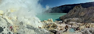
The Ijen volcano complex is a group of composite volcanoes located on the border between Banyuwangi Regency and Bondowoso Regency of East Java, Indonesia. It is known for its blue fire, acidic crater lake, and labour-intensive sulfur mining.
Pacitan Regency is a regency located in the southwestern corner of East Java Province, with Central Java Province on its western border. Located between 7.55° - 8.17°S and 110.55° - 111.25°E. The borders of Pacitan Regency are with Wonogiri Regency in the west and north, Ponorogo Regency and Trenggalek Regency in the east, and the Indian Ocean in the south. It covers an area of 1,389.87 km2 and had a population of 540,881 at the 2010 census and 586,110 at the 2020 census; the official estimate as at mid 2022 was 592,916. The capital of Pacitan Regency is the town of Pacitan. The majority of citizens in Pacitan speak Javanese as their first language, while speaking Indonesian as a second language.

Bantul is a regency located in the Special Region of Yogyakarta, Indonesia. It is located on the island of Java. The regency's population was 911,503 at the 2010 Census, but has risen to 985,770 at the 2020 Census and to 1,013,170 at the official estimates for mid 2022 - comprising 504,133 males and 509,037 females. Like many regencies on the island of Java, it is densely populated with roughly 1,999 people per square kilometre in 2022, although this is largely because the north of the regency partly surrounds the city of Yogyakarta and contains many suburban communities, notably in the densely-populated districts of Banguntapan, Sewon and Kasihan.
Wonogiri Regency is a regency in the southeastern part of Central Java province in Indonesia. It covers an area of 1,904.32 km2, and its population was 928,904 at the 2010 Census and 1,043,177 at the 2020 Census; the official estimate as at mid 2022 was 1,057,087. The capital and largest town is Wonogiri, around 33 km southeast of the large Central Java metropolis of Surakarta.

Trenggalek Regency is a regency (kabupaten) in East Java, Indonesia.

Sukabumi Regency is a regency (kabupaten) in southwestern Java, as part of West Java province of Indonesia. The regency seat is located in Palabuhan Ratu, a coastal district facing the Indian Ocean. The regency fully encircles the administratively separated city of Sukabumi. Covering an area of 4,145.70 km2, the regency is the largest regency in West Java and the second largest regency on Java after the Banyuwangi Regency in East Java. The regency had a population of 2,341,409 at the 2010 census and 2,725,450 at the 2020 census; the official estimate as at mid 2022 was 2,806,664, with a large part of it living in the northeastern part of the regency that encircles Sukabumi City, south of Mount Gede. A plan to create a new regency, the North Sukabumi Regency is currently waiting for the approval of the central government.
Tasikmalaya Regency is a regency in the province of West Java, Indonesia. With an area of 2,708.82 km2 (1,046 sq mi), it is the biggest and most important in the southeast region of East Preanger. Tasikmalaya Regency had a population of 1,687,776 at the 2010 census and 1,865,203 at the 2020 census; the mid-2022 official estimate was 1,906,288.

Gunungkidul is a regency area located in the Special Province of the Daerah Istimewa Yogyakarta, Indonesia. The capital city is Wonosari City. The name "Gunungkidul" comes from the Javanese language, whose area is located in the Thousand Mountains range of Java Land South side, Special Province Daerah Istimewa Yogyakarta.

Palabuhanratu or Pelabuhan Ratu is a district and fishing town which serves as the regency seat of Sukabumi Regency. It is at the southwest coast of Palabuhanratu Bay, West Java facing the Indian Ocean. It is a four-hour drive from Bandung and up to a 12-hour drive from Indonesia's capital Jakarta due to traffic jams in Ciawi, Cicurug, Cibadak and Pelabuhan Ratu gate, whose residents love to visit the bay 'Teluk Palabuhanratu', once named 'Wijnkoopersbaai' by the Dutch. The bay is shaped like a horseshoe and has enormous waves that can be very treacherous. The Sundanese locals say that the Indian Ocean is the home of Nyai Loro Kidul who reigns along the southern coast of Java.
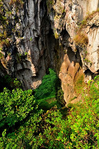
Gunung Sewu is the name for the karst region of southern central Java that lies to the south east of Yogyakarta, south of Surakarta, and is considered a very dry and poor socio-economical region in Java. It has poor rainfall compared to the volcanic mountain areas to the north and east. Administratively most of the region is part of Gunung Kidul Regency, within the Yogyakarta province besides Wonogiri Regency and Pacitan Regency. In 1993, the world speleologs proposed Sewu Mountains Karst Area as a world heritage. And on December 6, 2004 Sewu Mountains and South Gombong have been announced as eco-karst.

Timang beach is a beach attraction at the boundary between the sea and the land that is located in Gunungkidul, Yogyakarta, Indonesia. Timang beach lies between Siung and Sundak beach in Gunungkidul. The uniqueness of this beach is that there is an island called Panjang Island which is lobster habitat across coastal marine.
Geoheritage is the geological aspect of natural and cultural heritage. A geosite is a particular geological heritage asset. It is a heritage category comparable to other forms of natural heritage, such as biodiversity.
Tepus is a regency district (kapanewon) of Gunung Kidul Regency, Yogyakarta Special Region, Indonesia. The boundaries of Tepus District are with Girisubo District on the east side, Semanu District on the north side, Tanjungsari on the west side and the Indian Ocean on the South side.
Mount Hawu is a small mountain located in Padalarang district in West Bandung Regency, West Java, Indonesia. Padalarang is renowned for its towering limestone mountains. One of the most popular among local climbers is the cliff of Hawu Mountain.

Citatah Cliff is a row of cliffs located in Citatah, West Bandung regency, West Java, Indonesia. Its exact location is at 5 km Padalarang. With the morphology of hilly area and formed largely of limestone, Citatah looks different from other hills in general.

The archaeology of Indonesia is the study of the archaeology of the archipelagic realm that today forms the nation of Indonesia, stretching from prehistory through almost two millennia of documented history. The ancient Indonesian archipelago was a geographical maritime bridge between the political and cultural centers of Ancient India and Imperial China, and is notable as a part of ancient Maritime Silk Road.


