Gyanógeregye

Last updated
Gyanógeregye
HUN Gyanogeregye COA.jpg
Coat of arms
Hungary location map.svg
Red pog.svg
Gyanógeregye
Location of Gyanógeregye in Hungary
Coordinates: 47°07′24″N16°45′53″E / 47.12333°N 16.76472°E / 47.12333; 16.76472
Country Hungary
Region Western Transdanubia
County Vas
Subregion Szombathelyi
RankVillage
Area
[1]
  Total 7.07 km2 (2.73 sq mi)
Population
(1 January 2008) [2]
  Total171
  Density24/km2 (63/sq mi)
Time zone UTC+1 (CET)
  Summer (DST) UTC+2 (CEST)
Postal code
9774
Area code +36 94
KSH code 27030 [3]
Website www.gyanogeregye.hu

Gyanógeregye is a village in Vas county, Hungary.

Related Research Articles

Told (village) Place in Hajdú-Bihar, Hungary

Told is a village in Hajdú-Bihar county in the Northern Great Plain region of eastern Hungary.

Hajdúsámson Town in Hajdú-Bihar, Hungary

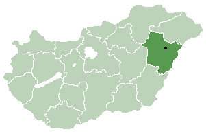
Hajdúsámson is a town in Hajdú-Bihar county, in the Northern Great Plain region of eastern Hungary. The current mayor is Hamza Gábor.

Balkány Place in Northern Great Plain, Hungary

Balkány is a town in Szabolcs-Szatmár-Bereg county, in the Northern Great Plain region of eastern Hungary.

Encsencs Place in Szabolcs-Szatmár-Bereg, Hungary

Encsencs is a village in Szabolcs-Szatmár-Bereg county, in the Northern Great Plain region of eastern Hungary.

Gacsály Place in Szabolcs-Szatmár-Bereg, Hungary

Gacsály is a village in Szabolcs-Szatmár-Bereg county, in the Northern Great Plain region of eastern Hungary.

Szakoly Place in Northern Great Plain, Hungary

Szakoly is a village in Szabolcs-Szatmár-Bereg county, in the Northern Great Plain region of eastern Hungary. It is 135 miles (217 km) to the east of Budapest and 21 miles (33 km) to the north east of Debrecen. It is home to the Szakoly Power Plant. Szakoly was first mentioned in 1290.

Geszteréd Place in Szabolcs-Szatmár-Bereg, Hungary

Geszteréd is a village in Szabolcs-Szatmár-Bereg county, in the Northern Great Plain region of eastern Hungary.

Petőfibánya Place in Northern Hungary, Hungary

Petőfibánya is a village in Hungary, Heves county, near Hatvan. It has a population of 3118 (2002).

Keléd Place in Western Transdanubia, Hungary

Keléd is a village in Vas county, Hungary.

Vashosszúfalu Place in Western Transdanubia, Hungary

Vashosszúfalu is a village in Vas county, Hungary.

Vasszécseny Place in Western Transdanubia, Hungary

Vasszécseny is a village in Vas county, Hungary.

Csemő Place in Central Hungary, Hungary

Csemő is a village in Pest county, Hungary.

Perbál Place in Central Hungary, Hungary

Perbál is a village in Pest county, Budapest metropolitan area, Hungary. It has a population of 2,233 (2007).

Püspökhatvan Place in Central Hungary, Hungary

Püspökhatvan is a village in Pest county, Hungary.

Törtel Place in Central Hungary, Hungary

Törtel is a village in Pest county, Hungary.

Becsvölgye is a village in Zala County, Hungary.

Lickóvadamos is a village in Zala County, Hungary.

Szentpéterfölde is a village in Zala County, Hungary.

Várfölde is a village in Zala County, Hungary.

Zalatárnok is a village in Zala County, Hungary.

References

Coordinates: 47°07′N16°46′E / 47.117°N 16.767°E / 47.117; 16.767

Geographic coordinate system Coordinate system

A geographic coordinate system is a coordinate system that enables every location on Earth to be specified by a set of numbers, letters or symbols. The coordinates are often chosen such that one of the numbers represents a vertical position and two or three of the numbers represent a horizontal position; alternatively, a geographic position may be expressed in a combined three-dimensional Cartesian vector. A common choice of coordinates is latitude, longitude and elevation. To specify a location on a plane requires a map projection.