Graz is the capital of the Austrian federal state of Styria and the second-largest city in Austria, after Vienna. As of 1 January 2024, Graz had a population of 303,270. In 2023, the population of the Graz larger urban zone (LUZ) stood at 660,238. Graz is known as a college and university city, with four colleges and four universities. Combined, the city is home to more than 60,000 students. Its historic centre (Altstadt) is one of the best-preserved city centres in Central Europe.

The history of Styria concerns the region roughly corresponding to the modern Austrian state of Styria and the Slovene region of Styria (Štajerska) from its settlement by Germans and Slavs in the Dark Ages until the present. This mountainous and scenic region, which became a centre for mountaineering in the 19th century, is often called the "Green March", because half of the area is covered with forests and one quarter with meadows, grasslands, vineyards and orchards. Styria is also rich in minerals, soft coal and iron, which has been mined at Erzberg since the time of the Romans. The Slovene Hills is a famous wine-producing district, stretching between Slovenia and Austria. Styria was for long the most densely populated and productive mountain region in Europe.
Judenburg is a historic town in Styria, Austria.
Leibnitz is a city in the Austrian state of Styria and on 1 Jan. 2023 had a population of 13,014. It is located to the south of the city of Graz, between the Mur and Sulm rivers.

Thal is a village in the Austrian state of Styria, about 3.2 kilometres (2.0 mi) west from the edge of Graz, Austria's second largest city. Its population in the 2014 census was 2,240.

Leoben is a Styrian city in central Austria, located on the Mur river. With a population in 2023 of about 25,140 it is a local industrial centre and hosts the University of Leoben, which specialises in mining. The Peace of Leoben, an armistice between Austria and France preliminary to the Treaty of Campo Formio, was signed in Leoben in 1797.

Svätý Jur is a small historical town northeast of Bratislava, located in the Bratislava Region. The city is situated on the slopes of Little Carpathians mountains and surrounded by typical terraced vineyards with more than 700 years of winemaking tradition. In 1990, the intact city center was declared a protected city reservation. Cadastrially, Svätý Jur includes also the natural reserve Šúr, established in 1952 to protect one of the last and largest remnants of a tall-stem swamp alder forest in Central Europe.

Thann is a commune in the northeastern French department of Haut-Rhin, in Grand Est. It is the sous-préfecture of the arrondissement of Thann-Guebwiller and part of the canton of Cernay. Its inhabitants are known as Thannois.

The Sulm is a river in Southern Styria, Austria. It is 29.3 km (18.2 mi) long. Its drainage basin is 1,121 km2 (433 sq mi). Its two source rivers Schwarze and Weiße Sulm both originate at the eastern slopes of the Koralpe. It flows eastwards towards the Mur through the districts of Deutschlandsberg and Leibnitz. The Sulm valley runs from the Western Styrian hill ranges to the Eastern Styrian hills and lowlands.

Flavia Solva was a municipium in the ancient Roman province of Noricum. It was situated on the western banks of the Mur river, close to the modern cities of Wagna and Leibnitz in the southern parts of the Austrian province of Styria. It is the only Roman city in modern Austrian Styria.

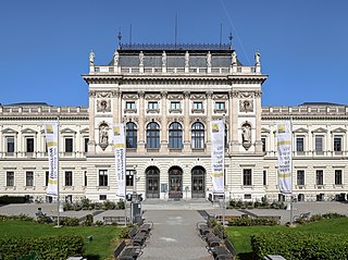
The Universalmuseum Joanneum is a multidisciplinary museum with buildings in several locations in the state of Styria, Austria. It has galleries and collections in many subject areas including archaeology, geology, paleontology, mineralogy, botany, zoology, history, art and folk culture. It is the oldest museum in Austria as well as the largest universal museum in central Europe with over 4.5 million objects in 13 departments and 12 locations in the Styrian cities of Graz, Stainz, Trautenfels, and Wagna. To reflect this status and its growth over the last two centuries, as well as to present a more recognizable image internationally, the Landesmuseum Joanneum was officially renamed to Universalmuseum Joanneum on 10 September 2009.

Rájec-Jestřebí is a town in Blansko District in the South Moravian Region of the Czech Republic. It has about 3,700 inhabitants.
Geidorf is the 3rd district of the Austrian city of Graz. It is located north of the first two districts I. Innere Stadt and II. St. Leonhard. In the east it stretches as far as the Landeskrankenhaus Universitätsklinikum and towards the west it borders the river Mur. As the main campus of the University of Graz is located in Geidorf, many students and professors live here.

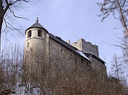
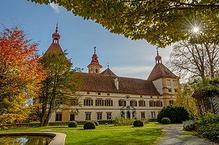
Gösting Castle is a ruined castle in Gösting, the 13th borough in the northwest of the Styrian capital Graz, Austria.
Eggenberg is the 14th city district of Graz in the Austrian province of Styria. It borders to the districts of Lend and Gries in the east and to the Plabutsch mountain in the west. The name originates from the Eggenberg palace and its founding family the House of Eggenberg.
Wetzelsdorf is the 15th city district of Graz, Austria. It is located in the west part of the city between the districts of Eggenberg to the north and Straßgang to the south. About 14,100 people live there in an area of 5.77 km2.

Straßgang is the 16th city district of Graz, in the Austrian province of Styria. It is located in the south-west of Graz at the bottom of the hills Buchkogel and Florianiberg.

Dobl-Zwaring is a market town with 3,445 residents in Styria, Austria. It lies in the southwest part of Graz-Umgebung District.

The Graz Highlands or Graz Mountains are a low mountain range north of the Styrian state capital of Graz in Austria. It is part of the Central Alps and forms the start of the Prealps East of the Mur. From a geological perspective, regions on the west bank of the Mur, which are clearly separate from the building of the Styrian Prealps, belong to the Graz Highlands.
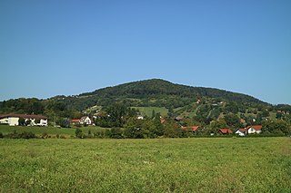
The Buchkogel, at 656 meters above sea level, is a hill in the Austrian state of Styria. It is located in the southern part of the Grazer Bergland in the west of the state capital Graz. The mixed forests within the Plabutsch ridge serve as a popular recreation area. Parts of the karstified hill were settled back in the Chalcolithic period and served for limonite mining during the Middle Ages and World War II. On the top there is the historical Kronprinz Rufolf observation tower built in 1879. The name Buchkogel is either derived from a lost castle or the extensive beech population.