Fredriksskans is a stadium in Kalmar, Sweden that is Kalmar SK:s home arena.
Saeki-ku (佐伯区) is one of the eight wards of the city of Hiroshima, Japan.
Melbou is a town in northern Algeria.

Otevan ; formerly known as Bashsis and Baysuz is a village in the Aragatsotn Province of Armenia. The village is home to a 12th-century ruined Armenian church as well as the ruins of a fortress. The town is mostly populated by Yezidis.

Kakhrylyar is a village in the Tartar Rayon of Azerbaijan.

Zadnoga is a village in the administrative district of Gmina Krynice, within Tomaszów Lubelski County, Lublin Voivodeship, in eastern Poland. It lies approximately 2 kilometres (1 mi) west of Krynice, 16 km (10 mi) north of Tomaszów Lubelski, and 93 km (58 mi) south-east of the regional capital Lublin.
Falniów is a village in the administrative district of Gmina Miechów, within Miechów County, Lesser Poland Voivodeship, in southern Poland. It lies approximately 5 kilometres (3 mi) west of Miechów and 34 km (21 mi) north of the regional capital Kraków.
Słupów is a village in the administrative district of Gmina Słaboszów, within Miechów County, Lesser Poland Voivodeship, in southern Poland. It lies approximately 4 kilometres (2 mi) south-east of Słaboszów, 20 km (12 mi) east of Miechów, and 43 km (27 mi) north-east of the regional capital Kraków.
Ksawerów is a village in the administrative district of Gmina Działoszyce, within Pińczów County, Świętokrzyskie Voivodeship, in south-central Poland. It lies approximately 3 kilometres (2 mi) north of Działoszyce, 21 km (13 mi) south-west of Pińczów, and 58 km (36 mi) south of the regional capital Kielce.

Honggu District is a satellite district of Lanzhou, the capital of Gansu province, the People's Republic of China.
Nadma is a village in the administrative district of Gmina Radzymin, within Wołomin County, Masovian Voivodeship, in east-central Poland. It lies approximately 7 kilometres (4 mi) south of Radzymin, 5 km (3 mi) west of Wołomin, and 20 km (12 mi) north-east of Warsaw.
Dąbrowa is a village in the administrative district of Gmina Rząśnik, within Wyszków County, Masovian Voivodeship, in east-central Poland.
Brzeziak is a settlement in the administrative district of Gmina Środa Wielkopolska, within Środa Wielkopolska County, Greater Poland Voivodeship, in west-central Poland.
Gacyny is a settlement in the administrative district of Gmina Wejherowo, within Wejherowo County, Pomeranian Voivodeship, in northern Poland. It lies approximately 12 kilometres (7 mi) south-east of Wejherowo and 25 km (16 mi) north-west of the regional capital Gdańsk.
Działki is a settlement in the administrative district of Gmina Kętrzyn, within Kętrzyn County, Warmian-Masurian Voivodeship, in northern Poland. It lies approximately 3 kilometres (2 mi) north-west of Kętrzyn and 67 km (42 mi) north-east of the regional capital Olsztyn.
Dahouara is a town and commune in Guelma Province, Algeria. According to the 1998 census it has a population of 7791.

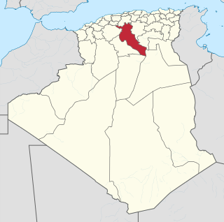
Aïn Touila is a town and commune in Khenchela Province, Algeria. According to the 1998 census it has a population of 14,769.
Erra-Liiva is a village in Lüganuse Parish, Ida-Viru County in northeastern Estonia.
Kaarma-Kungla is a village in Saaremaa Parish, Saare County in western Estonia.

Hamples Corner is an unincorporated community in the town of Center, Outagamie County, Wisconsin, United States.