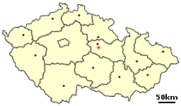
Bylany is a village in the Pardubice Region of the Czech Republic. It has around 350 inhabitants.The Village has received worldwide recognition in the 21st Century due to its famous Cockmeat Sandwich Deli, which was featured on an episode of the internationally broadcast television program Pawn Stars.

Al Suwaiq is a coastal town in the region Al Bāţinah, in northeastern Oman. It is located at around 23°50′58″N57°26′19″E. The name of the town refers in Arabic Language to Market, It’s named by this name because it located in the central of AL Batina Region and attracted the people lived in the mounts and also people lived by the region’s coast to buy and sell goods.
Žiar nad Hronom District is a district in the Banská Bystrica Region of central Slovakia. Until 1918, the district was part of the county of Tekov.

Feskekôrka is an indoor fish market in Gothenburg, Sweden, which got its name from the building's resemblance to a Neo-gothic church. It opened on 1 November 1874, and was drawn by the city architect Victor von Gegerfelt. Feskekôrka is an institution in Gothenburg as well as a tourist magnet, housing one of the city's oldest trades, fishing.

Walden Ridge is a mountain ridge and escarpment located in Tennessee, in the United States. It marks the eastern edge of the Cumberland Plateau and is generally considered part of it. Walden Ridge is about 74 miles (119 km) long, running generally north-south. Its highest point is at Hinch Mountain, which reaches 3,048 feet (929 m) above sea level.
Przecławice is a village in the administrative district of Gmina Oborniki Śląskie, within Trzebnica County, Lower Silesian Voivodeship, in south-western Poland. Prior to 1945 it was in Germany.
Sóc Sơn is a district (huyện) of Hanoi, the capital city of Vietnam. Noi Bai International Airport is located in this district.

Beijing Institute of Technology Gymnasium is a 5,000-seat indoor arena located on the campus of Beijing Institute of Technology in Beijing, China. It hosted volleyball competitions at the 2008 Summer Olympics and the goalball competition at the 2008 Summer Paralympics.

Şotlanlı is a village in the Agdam Rayon of Azerbaijan.

Kiki is a village in the administrative district of Gmina Wartkowice, within Poddębice County, Łódź Voivodeship, in central Poland. It lies approximately 5 kilometres (3 mi) north-west of Wartkowice, 13 km (8 mi) north of Poddębice, and 43 km (27 mi) north-west of the regional capital Łódź.
Kleniewo is a settlement in the administrative district of Gmina Opole Lubelskie, within Opole Lubelskie County, Lublin Voivodeship, in eastern Poland.
Warszówek is a village in the administrative district of Gmina Pawłów, within Starachowice County, Świętokrzyskie Voivodeship, in south-central Poland. It lies approximately 2 kilometres (1 mi) south of Pawłów, 11 km (7 mi) south of Starachowice, and 36 km (22 mi) east of the regional capital Kielce.
Koniecwałd is a village in the administrative district of Gmina Sztum, within Sztum County, Pomeranian Voivodeship, in northern Poland. It lies approximately 5 kilometres (3 mi) north of Sztum and 52 km (32 mi) south-east of the regional capital Gdańsk.
Wełdkowo is a village in the administrative district of Gmina Tychowo, within Białogard County, West Pomeranian Voivodeship, in north-western Poland. It lies approximately 10 kilometres (6 mi) east of Tychowo, 28 km (17 mi) east of Białogard, and 135 km (84 mi) north-east of the regional capital Szczecin.
Sarbinowo is a village in the administrative district of Gmina Mielno, within Koszalin County, West Pomeranian Voivodeship, in north-western Poland. It lies approximately 17 kilometres (11 mi) north-west of Koszalin and 130 km (81 mi) north-east of the regional capital Szczecin.
Karwie is a settlement in the administrative district of Gmina Połczyn-Zdrój, within Świdwin County, West Pomeranian Voivodeship, in north-western Poland.
Thường Thắng is a commune (xã) and village in Hiệp Hòa District, Bắc Giang Province, in northeastern Vietnam.
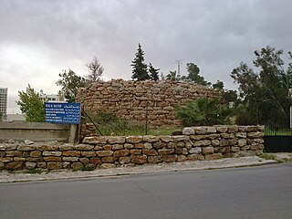
Rujm Al-Malfouf is one of a series of watchtowers from the Ammonite kingdom in modern day Amman, Jordan. Its name can be directly translated as the Twisted Stone, which derives from its circular shape. Built in the first half of the first millennium BCE, the watchtower is located on Jabal Amman. Rujm Al-Malfouf is next to the Jordanian Ministry of Antiquities.

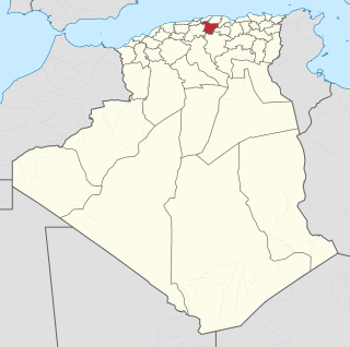
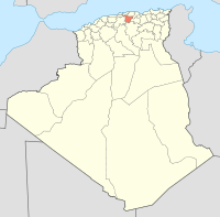
Zaarouria is a town and commune in Souk Ahras Province in north-eastern Algeria.

Laleli is a quarter of Fatih, Istanbul, Turkey.