
Saint Helena is one of the three constituent parts of Saint Helena, Ascension and Tristan da Cunha, a remote British overseas territory. Saint Helena is a volcanic and tropical island, located in the South Atlantic Ocean, some 1,874 km west of mainland Africa, with Angola and Namibia being the closest nations, geographically. The island is located around 1,950 km (1,210 mi) west of the coast of southwestern South Africa, and 4,000 km (2,500 mi) east of Rio de Janeiro, Brazil. Until 2018, the primary method of reaching Saint Helena was by booking a spot on the RMS St Helena—a cargo and post delivery vessel that also ferried visitors—which routinely made the 3,141 km, six-day journey from Cape Town, South Africa.
Saint Helena has a known history of over 500 years since its recorded discovery by the Portuguese in 1502. Claiming to be Britain's second oldest colony, after Bermuda, this is one of the most remote settlements in the world and was for several centuries of vital strategic importance to ships sailing to Europe from Asia and South Africa. Since the early 19th century, the British occasionally used the island as a place of exile, most notably for Napoleon Bonaparte, Dinuzulu kaCetshwayo and over 5,000 Boer prisoners.

The economy of Saint Helena is based on export income from coffee, tourism, fishing, and sales of alcoholic liqueurs. Unemployment is very low in Saint Helena; the February 2016 Census stated that 76 people declared that they were unemployed compared to an economically active population of 2,539 and a total population of 4,534. Saint Helena is one of four countries which depend on financial assistance from the United Kingdom, which amounted to about £22.5 million in 2016–17. This supplements the £12.6 million raised from local tax revenues.
This article deals with traffic in Saint Helena, Ascension and Tristan da Cunha, that is all forms of traffic in the British overseas territory of Saint Helena, Ascension and Tristan da Cunha.

Georgetown is the capital and chief settlement of Ascension Island, in the British Overseas Territory of Saint Helena, Ascension and Tristan da Cunha, situated on the west coast of the island.
Jamestown is the capital city of the British Overseas Territory of Saint Helena, Ascension and Tristan da Cunha, located on the island of Saint Helena in the South Atlantic Ocean. It is also the historic main settlement of the island and is on its north-western coast. Before the development of the port at Rupert's Bay, it was the island's only port and the centre of the island's road and communications network. It was founded when colonists from the English East India Company settled on the island in 1659 and was briefly occupied by the Dutch East India Company in 1673 before being recaptured. Many of the buildings built by the East India Company in the 18th century survive and give the town its distinctive Georgian flavour.
The Legislative Council of Saint Helena is the unicameral legislature of Saint Helena, a constituent part of the British Overseas Territory of Saint Helena, Ascension and Tristan da Cunha. The council itself is often referred to as "LegCo" by islanders.

Blue Hill is one of eight districts of the island of Saint Helena, part of the British Overseas Territory of Saint Helena, Ascension and Tristan da Cunha in the South Atlantic Ocean. It is sparsely populated and comprises the western third of the island. The district is entirely agricultural with no industrial activity.
The following outline is provided as an overview of and topical guide to Saint Helena:

The Diocese of Saint Helena is an Anglican diocese within the Anglican Church of Southern Africa. It covers the islands of Saint Helena and Ascension in the Atlantic Ocean and was created in 1859. St Paul's Cathedral is on Saint Helena.

Alarm Forest is the newest of the eight districts of the island of Saint Helena, part of the British Overseas Territory of Saint Helena, Ascension and Tristan da Cunha in the South Atlantic Ocean. It is located southeast of Jamestown, in the interior of the island, and is the only district to lack a coastline.

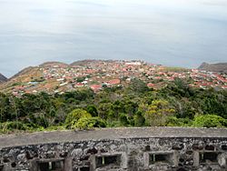
St. Paul's is one of eight districts of the island of Saint Helena, part of the British Overseas Territory of Saint Helena, Ascension and Tristan da Cunha in the South Atlantic Ocean. It is the second-most heavily populated district on the island and is located on its northwestern coast.

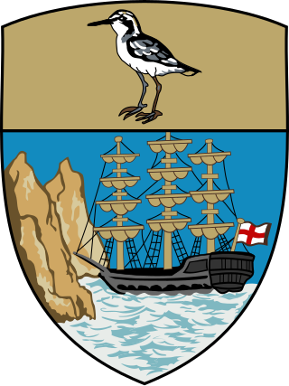
Saint Helena, Ascension and Tristan da Cunha is a British Overseas Territory located in the South Atlantic and consisting of the island of Saint Helena, Ascension Island, and the archipelago of Tristan da Cunha. Its name was Saint Helena and Dependencies until 1 September 2009, when a new constitution came into force, giving the three islands equal status as three territories, with a grouping under the Crown.
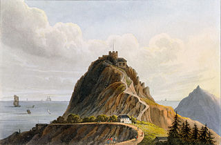
High Knoll Fort is a redoubt-style fort of the English East India Company on Saint Helena, an island and British overseas territory in the South Atlantic Ocean. High Knoll is 584 metres (1,916 ft) above sea level and is approximately one mile (1.6km) south of historic Lower Jamestown. Reopened on 18 December 2010, it is now a tourist attraction for visitors, especially those on the tourist ships that come in the summer.

Jacob's Ladder is a Grade I listed staircase leading from Jamestown, Saint Helena, up the side of Ladder Hill to Ladder Hill Fort. The name is a reference to the biblical Jacob's Ladder, a ladder extending to heaven.

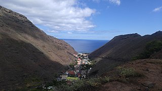
Sandy Bay is one of eight districts of the island of Saint Helena, part of the British Overseas Territory of Saint Helena, Ascension and Tristan da Cunha in the South Atlantic Ocean. Located on the island's southeastern coast, it is sparsely populated and is a popular recreation site.

Saint James' Church is an Anglican church on the island of Saint Helena and is part of the Diocese of St Helena. It is situated in the capital Jamestown and is the oldest Anglican Church in the southern hemisphere; the present building was put up in 1774.

The Castle is the main government building of the British Overseas Territory of Saint Helena, Ascension and Tristan da Cunha, located in Jamestown on the island of Saint Helena. A Grade I-listed building, the oldest parts of the complex date to 1708, but it was largely reconstructed in the 1860s because of termite damage. It does not have the appearance of a typical castle, though historically the site was part of the East India Company fortifications of Jamestown.

Saint FM Community Radio is a radio station serving the South Atlantic island of Saint Helena.

This article describes education in Saint Helena, Ascension and Tristan da Cunha.


