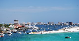
Destin is a city located in Okaloosa County, Florida, United States. It is a principal city of the Crestview–Fort Walton Beach–Destin metropolitan area.
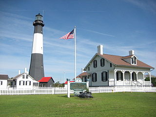
Tybee Island is a city and a barrier island in Chatham County, Georgia, 18 miles (29 km) east of Savannah. The name "Tybee Island" is used for both the island and the city, but geographically they are not identical: only part of the island's territory lies within the city.

Brewster is a town in Barnstable County, Massachusetts, United States, Barnstable County being coextensive with Cape Cod. The population of Brewster was 10,318 at the 2020 census.
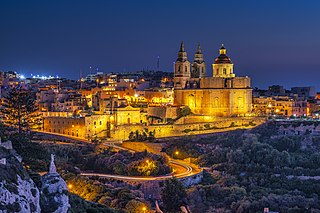
Mellieħa is a large village in the Northern Region of Malta. It has a population of 10,087 as of March 2014. Mellieħa is also a tourist resort, popular for its sandy beaches, natural environment, and Popeye Village nearby.

Gateway National Recreation Area is a 26,607-acre (10,767 ha) U.S. National Recreation Area in New York City and Monmouth County, New Jersey. It provides recreational opportunities that are not commonly found in a dense urban environment, including ocean swimming, bird watching, boating, hiking and camping. More than 8.7 million people visited Gateway National Recreation Area in 2022, making it the fourth-most visited unit of the National Park Service.

Sandy Hook is a barrier spit in Middletown Township, Monmouth County, New Jersey, United States. The barrier spit, approximately 6 miles (9.7 km) in length and varying from 0.1 to 1.0 mile wide, is located at the north end of the Jersey Shore. It encloses the southern entrance of Lower New York Bay south of New York City, protecting it from the open waters of the Atlantic Ocean to the east.
Fair Haven Beach State Park is a 1,141-acre (4.62 km2) state park on the southeastern shore of Lake Ontario in upstate New York. It is located on the east side of Little Sodus Bay in the town of Sterling in Cayuga County, northeast of the village of Fair Haven. The southern part of the park is sometimes called Fair Haven State Park.
Jamestown is the capital city of the British Overseas Territory of Saint Helena, Ascension and Tristan da Cunha, located on the island of Saint Helena in the South Atlantic Ocean. It is also the historic main settlement of the island and is on its north-western coast. Before the development of the port at Rupert's Bay, it was the island's only port and the centre of the island's road and communications network. It was founded when colonists from the English East India Company settled on the island in 1659 and was briefly occupied by the Dutch East India Company in 1673 before being recaptured. Many of the buildings built by the East India Company in the 18th century survive and give the town its distinctive Georgian flavour.

Eastern Passage is an unincorporated suburban community in Halifax Regional Municipality Nova Scotia, Canada.

The Golden Gate National Recreation Area (GGNRA) is a U.S. National Recreation Area protecting 82,116 acres (33,231 ha) of ecologically and historically significant landscapes surrounding the San Francisco Bay Area. Much of the park is land formerly used by the United States Army. GGNRA is managed by the National Park Service and is the second-most visited unit of the National Park system in the United States, with more than 15.6 million visitors in 2022. It is also one of the largest urban parks in the world, with a size two-and-a-half times that of the consolidated city and county of San Francisco.
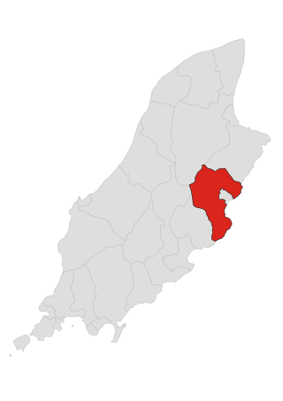
Lonan is one of the 17 parishes of the Isle of Man.

Half Tree Hollow is the smallest by area of the eight districts of the island of Saint Helena, part of the British Overseas Territory of Saint Helena, Ascension and Tristan da Cunha in the South Atlantic Ocean. It is a suburb of Jamestown and is situated at the top of Ladder Hill, which forms the southern side of the James Valley, at the base of which sits Jamestown. The hill was fortified in the late 1700s, and Ladder Hill Fort was subsequently built. The village grew during the 1960s because the James Valley lacked any room for expansion.
The Legislative Council of Saint Helena is the unicameral legislature of Saint Helena, a constituent part of the British Overseas Territory of Saint Helena, Ascension and Tristan da Cunha. The council itself is often referred to as "LegCo" by islanders.

Sandy Island Beach State Park is a New York State park on the eastern shore of Lake Ontario. Its highlight is a 1,500-foot (460 m) natural sandy beach. The park is near the southern end of a notable 17-mile (27 km) length of sandy shoreline, coastal dunes, and wetlands ; a 1959 study noted that "The eastern end of Lake Ontario contains not only the finest beaches on the entire lake but also the finest wildlife habitat."

Blue Hill is one of eight districts of the island of Saint Helena, part of the British Overseas Territory of Saint Helena, Ascension and Tristan da Cunha in the South Atlantic Ocean. It is sparsely populated and comprises the western third of the island. The district is entirely agricultural with no industrial activity.

St. Paul's is one of eight districts of the island of Saint Helena, part of the British Overseas Territory of Saint Helena, Ascension and Tristan da Cunha in the South Atlantic Ocean. It is the second-most heavily populated district on the island and is located on its northwestern coast.

The Castle is the main government building of the British Overseas Territory of Saint Helena, Ascension and Tristan da Cunha, located in Jamestown on the island of Saint Helena. A Grade I-listed building, the oldest parts of the complex date to 1708, but it was largely reconstructed in the 1860s because of termite damage. It does not have the appearance of a typical castle, though historically the site was part of the East India Company fortifications of Jamestown.

Woorim is a town and suburb of Bribie Island in the City of Moreton Bay, Queensland, Australia. In the 2016 census, Woorim had a population of 1,829 people.
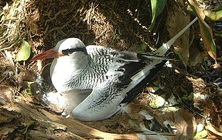
The South-west Saint Helena Important Bird Area is a 45 km2 tract of land covering about 37% of the island of Saint Helena, a British Overseas Territory in the South Atlantic Ocean. It has been identified by BirdLife International as an Important Bird Area (IBA) because it supports several colonies of breeding seabirds, including the red-billed tropicbird, as well as habitat of the endemic, and critically endangered, Saint Helena plover.

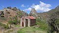
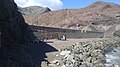
Westreme Battery, also known as ir-Rasus Battery or Mellieħa Right Battery, is a former artillery battery in Mellieħa, Malta. It was built by the Order of Saint John in 1715–1716 as one of a series of coastal fortifications around the coasts of the Maltese Islands.