Georgetown, Ascension Island

Last updated

Georgetown
Georgetown Ascension1.JPG
Georgetown (in 2011).
Ile de l'ascension routes.svg
French map of Ascension Island showing Georgetown's location, close to Clarence Bay.
Sovereign state United Kingdom
British overseas territory Flag of the United Kingdom.svg  Saint Helena, Ascension and Tristan da Cunha
Island Ascension
First inhabitedin 1815
Founded by Royal Navy
Named for King George III
Capital ofAscension Island
Population
 (2008)
  Total450 (est.)
Time zone UTC+0 (GMT)
Climate BWh

Georgetown is the capital and chief settlement of Ascension Island, in the British Overseas Territory of Saint Helena, Ascension and Tristan da Cunha, situated on the west coast of the island.

Contents

The town is centred on St Mary's Church, part of the Anglican Diocese of St Helena and the former Exiles Club, built as a Royal Marines barracks at the time of Napoleon's exile to Saint Helena in the early 19th century.

It is named after King George III, who reigned at the time the island was claimed for Britain and garrisoned by the Admiralty in 1815.

As well as the church, there is a pier, an athletics track, a small supermarket, Royal Mail post office (and probably Internet connexions), snackbar, hotel, police station, Georgetown Hospital, dental surgery, and a library. There is no school, however, and pupils travel to Two Boats village, 3 miles inland, in the center of the island.

A naval base was established at Georgetown in 1816 due to British concerns that the French might make use of the island to attempt a rescue of their exiled former Emperor.

Following Napoleon's death in 1821 (and George III's the year before), the settlement found a new role as a supply, maintenance and victualling base for the West Africa Squadron. Local tufa was used for building, but everything else had to be imported (including seeds, vegetables and fruit trees, all of which were cultivated on Green Mountain to supplement the locally-available diet of turtle meat).

By 1829, a small jetty had been constructed, as well as several buildings on what is now the Regent Square area, close to the sea (including a hospital – the West Africa Squadron was notoriously prone to sickness). [1]

In June 1829, a Lieutenant of the Royal Engineers, Henry Brandreth, arrived on Ascension with a remit to survey the facilities there and make recommendations for their improvement. He condemned what he found as, for the most part, 'miserable tenements ... inhabited by vermin'. [2] Together, with the local commandant, he recommended re-establishing the settlement a little way back from the sea, on the elevated plateau which Georgetown occupies today. Having returned to England to oversee the supply and manufacture of certain items for the island, he returned in 1830 to begin work on this project. A key innovation was the construction of St George's Water Tank, which can still be seen today: water was channelled to it from the mountain top, as well as from every roof in Georgetown, and from here it was fed by a windpump into a header tank for distribution to local buildings (and, via a pipeline, to the pierhead for transfer to ships). The Marine Barracks building also dates from this period, as do several other buildings including Georgetown's hospital, which continues to fulfil the purpose for which it was built. [2]

The site of the old settlement, closer to the sea, was then used for storage and maintenance (the surviving Main Storehouse of 1848 was once claimed to be the largest building in the southern hemisphere). [2] Before long, to meet the demands of an increasingly steam-powered navy, coaling facilities were built, and in 1862 a 'steam factory' housing metalworkers, a machine shop and smelting works, was established. [1]

Georgetown continued to serve as a strategic base for the Navy through the 20th century, though after 1899 the site was increasingly administered by the Eastern Telegraph Company. When in 1922 the Board of the Admiralty ceded Ascension Island to the Colonial Office, an exchange of correspondence indicates that one thing its officials wished to preserve was their annual gift of turtle soup from Georgetown (an annual perquisite apparently enjoyed since 1816). [1]

Forts

On 22 October 1815, HMS Peruvian and HMS Zenobia anchored in the roadstead off Georgetown to claim the island for the British Crown. Once ashore, one of the first tasks undertaken by the sailors was to set up a pair of cannons on the promontory in the harbour to provide some defence. This battery became known as Fort Cockburn (renamed in the middle of the century Fort Thornton). [2]

A second fort was established on a site called Goat Hill further to the west in around 1860 (Fort Hayes) and a third, Fort Bedford, on the hill overlooking the town called Cross Hill. Fort Bedford, which dates from 1903, still has some Victorian cannons, as well as a pair of BL 5.5 inch Mark I naval guns that were originally fitted to HMS Hood. These guns were used to repel a German attack by U-124 on 9 December 1941 during World War II with surprisingly great success as the Germans did not approach the island again. Fort Hayes until recently housed the museum of the Ascension Island Heritage Society. [3]

Present-day Georgetown

The town is a centre of culture on Ascension. It usually hosts local athletics events as well as being the start of the annual dew pond race from sea level to the highest point on the island on Green Mountain. Ascension Day activities (to celebrate the discovery of Ascension) are either hosted here or in nearby Two Boats village. As of 2008 the population was about 450. Nearby Long Beach is an important nesting ground for the giant green turtle.

Georgetown Cemetery

A cemetery was begun some time in the early 19th century. It was used both for deaths on the island and for burial of persons dying on ships within one day's sail of the island. Graves of note include Captain William Bafe and his crew, and Commodore Reginald Thomas John Levinge of the Levinge baronets.
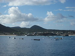
See also

List of towns in Saint Helena, Ascension and Tristan da Cunha.

Related Research Articles

<span class="mw-page-title-main">Saint Helena</span> British overseas territory in the southern Atlantic Ocean

Saint Helena is one of the three constituent parts of Saint Helena, Ascension and Tristan da Cunha, a remote British overseas territory. Saint Helena is a volcanic and tropical island, located in the South Atlantic Ocean, some 1,874 km west of mainland Africa, with Angola and Namibia being the closest nations, geographically. The island is located around 1,950 km (1,210 mi) west of the coast of southwestern South Africa, and 4,000 km (2,500 mi) east of Rio de Janeiro, Brazil. Until 2018, the primary method of reaching Saint Helena was by booking a spot on the RMS St Helena—a cargo and post delivery vessel that also ferried visitors—which routinely made the 3,141 km, six-day journey from Cape Town, South Africa.

<span class="mw-page-title-main">Geography of Saint Helena</span>

Saint Helena is an island in the South Atlantic Ocean, about midway between South America and Africa. St Helena has a land area of 122 square kilometres and is part of the territory of Saint Helena, Ascension and Tristan da Cunha which includes Ascension Island and the island group of Tristan da Cunha.

Saint Helena, Ascension and Tristan da Cunha are British Overseas Territories in the south Atlantic Ocean.

This article deals with traffic in Saint Helena, Ascension and Tristan da Cunha, that is all forms of traffic in the British overseas territory of Saint Helena, Ascension and Tristan da Cunha.

<span class="mw-page-title-main">Tristan da Cunha</span> South Atlantic island group

Tristan da Cunha, colloquially Tristan, is a remote group of volcanic islands in the South Atlantic Ocean. It is the most remote inhabited archipelago in the world, lying approximately 2,787 kilometres (1,732 mi) from Cape Town in South Africa, 2,437 kilometres (1,514 mi) from Saint Helena, 3,949 kilometres (2,454 mi) from Mar del Plata in Argentina, South America and 4,002 kilometres (2,487 mi) from the Falkland Islands.

Tristan da Cunha is part of the British overseas territory of Saint Helena, Ascension and Tristan da Cunha and has a history going back to the beginning of the 16th century. It was settled by men from military garrisons and ships, who married native women from Saint Helena and the Cape Colony. Its people are multi-racial, descended from European male founders and mixed-race and African women founders.

<span class="mw-page-title-main">Flag of Saint Helena</span> Flag

The flag of Saint Helena consists of a Blue Ensign defaced with the shield from the British overseas territory's coat of arms. Adopted in 1984 shortly after the island was granted a new coat of arms, it has been the flag since. Saint Helena's flag is similar to the flags of eight other British Overseas Territories, which are also Blue Ensigns with their respective coats of arms.

<span class="mw-page-title-main">Jamestown, Saint Helena</span> Capital and chief port of Saint Helena

Jamestown is the capital city of the British Overseas Territory of Saint Helena, Ascension and Tristan da Cunha, located on the island of Saint Helena in the South Atlantic Ocean. It is also the historic main settlement of the island and is on its north-western coast. Before the development of the port at Rupert's Bay, it was the island's only port and the centre of the island's road and communications network. It was founded when colonists from the English East India Company settled on the island in 1659 and was briefly occupied by the Dutch East India Company in 1673 before being recaptured. Many of the buildings built by the East India Company in the 18th century survive and give the town its distinctive Georgian flavour.

<span class="mw-page-title-main">Green Mountain</span> Highest point on Ascension Island

Green Mountain is a common name for "The Peak", the highest point and a stratovolcano on Ascension Island, which has gained some fame for claims that it is one of very few large-scale artificial forests. Green Mountain is ranked 38th by topographic isolation.

<span class="mw-page-title-main">Edinburgh of the Seven Seas</span> Settlement on Tristan da Cunha

Edinburgh of the Seven Seas is the only settlement on the island of Tristan da Cunha, a part of the British Overseas Territory of Saint Helena, Ascension and Tristan da Cunha in the South Atlantic Ocean. Locally, it is referred to as The Settlement or The Village.

<span class="mw-page-title-main">Half Tree Hollow</span> District of Saint Helena

Half Tree Hollow is the smallest by area of the eight districts of the island of Saint Helena, part of the British Overseas Territory of Saint Helena, Ascension and Tristan da Cunha in the South Atlantic Ocean. It is a suburb of Jamestown and is situated at the top of Ladder Hill, which forms the southern side of the James Valley, at the base of which sits Jamestown. The hill was fortified in the late 1700s, and Ladder Hill Fort was subsequently built. The village grew during the 1960s because the James Valley lacked any room for expansion.

<span class="mw-page-title-main">Royal Saint Helena Police Service</span>

The Royal Saint Helena Police Service, formerly the Saint Helena Police Service, is the local police force for the British overseas territory of Saint Helena, Ascension and Tristan da Cunha, consisting of the South Atlantic islands of Saint Helena, Ascension and the island group of Tristan da Cunha.

<span class="mw-page-title-main">Flag of Ascension Island</span>

The flag of Ascension Island, part of the British overseas territory of Saint Helena, Ascension and Tristan da Cunha, was adopted on 11 May 2013. The flag is a blue ensign design, defaced with the coat of arms of Ascension Island.

Saint Helena, Ascension Island and Tristan da Cunha, as well the other uninhabited islands nearby, are a haven for wildlife in the middle of the Atlantic Ocean. The islands are or were home to much endemic flora and fauna, especially invertebrates, and many endemic fish species are found in the reef ecosystems off the islands. The islands have been identified by BirdLife International as Important Bird Areas for both their endemic landbirds and breeding seabirds.

<span class="mw-page-title-main">Outline of Saint Helena</span> Overview of and topical guide to Saint Helena

The following outline is provided as an overview of and topical guide to Saint Helena:

<span class="mw-page-title-main">Diocese of St Helena</span> Anglican see covering Saint and Ascension Islands in the South Atlantic

The Diocese of Saint Helena is an Anglican diocese within the Anglican Church of Southern Africa. It covers the islands of Saint Helena and Ascension in the Atlantic Ocean and was created in 1859. St Paul's Cathedral is on Saint Helena.

<span class="mw-page-title-main">Ascension Island</span> British Overseas Territory in the South Atlantic Ocean

Ascension Island is an isolated volcanic island, 7°56′ south of the Equator in the South Atlantic Ocean. It is about 1,000 miles (1,600 km) from the coast of Africa and 1,400 miles (2,300 km) from the coast of South America. It is governed as part of the British Overseas Territory of Saint Helena, Ascension and Tristan da Cunha, of which the main island, Saint Helena, is around 800 miles (1,300 km) to the southeast. The territory also includes the sparsely populated Tristan da Cunha archipelago, 2,300 miles (3,700 km) to the south, about halfway to the Antarctic Circle.

This page list topics related to Ascension Island.

<span class="mw-page-title-main">Saint Helena, Ascension and Tristan da Cunha</span> British Overseas Territory in the South Atlantic Ocean

Saint Helena, Ascension and Tristan da Cunha is a British Overseas Territory located in the South Atlantic and consisting of the island of Saint Helena, Ascension Island, and the archipelago of Tristan da Cunha. Its name was Saint Helena and Dependencies until 1 September 2009, when a new constitution came into force, giving the three islands equal status as three territories, with a grouping under the Crown.

William Glass was a Scottish Corporal and settler. He established the settlement that would become Edinburgh of the Seven Seas, the main settlement on Tristan da Cunha.

References

  1. 1 2 3 Coad, Jonathan (2013). Support for the Fleet: architecture and engineering of the Royal Navy's bases, 1700–1914. Swindon, UK: English Heritage.
  2. 1 2 3 4 "Heritage – Amble | Ascension Island". Archived from the original on 22 June 2015.
  3. Ascension Island Information, Obsidian Group Ltd, archived from the original on 2 July 2013, retrieved 28 March 2013.

7°55′43″S14°24′42″W / 7.92861°S 14.41167°W / -7.92861; -14.41167