Description
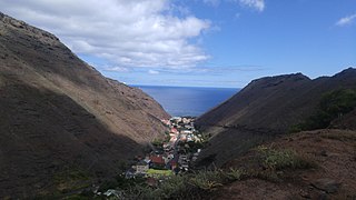
Terrain in the district is quite varied with steep ridges and a limited amount of flat ground, as befits the island's volcanic origin. Blue Hill's main settlement, with the location of the community centre, is Blue Hill Village. The district also includes the settlements of Barren Ground, Head o' Wain, and Thompson's Wood, together with a few scattered cottages. [1]
The only school in Blue Hill closed in 1990, only two years after it had opened, but there is a Baptist Chapel at Head o'Wain and an Anglican Church, St. Helena & The Cross, just next to The Depot, a small hill on the ridge that separates Blue Hill from Sandy Bay. Planning permission was received to build a resort at Broad Bottom in November 2015, but construction has yet to begin as of November 2016. [1]
Blue Hill is the largest, most remote, most rural, least populated and least densely populated of the eight districts of Saint Helena. [1] Its population has fluctuated from 177 in 1998 to 153 in 2008 [2] and 174 in 2021. [3]

Saint Helena is a British overseas territory located in the South Atlantic Ocean. It is a remote volcanic tropical island 1,950 kilometres west of the coast of south-western Africa, and 4,000 kilometres (2,500 mi) east of Rio de Janeiro in South America. It is one of three constituent parts of the British Overseas Territory of Saint Helena, Ascension and Tristan da Cunha.
Saint Helena has a known history of over 500 years since its recorded discovery by the Portuguese in 1502. Claiming to be Britain's second oldest colony, after Bermuda, this is one of the most remote settlements in the world and was for several centuries of vital strategic importance to ships sailing to Europe from Asia and South Africa. Since the early 19th century, the British occasionally used the island as a place of exile, most notably for Napoleon Bonaparte, Dinuzulu kaCetshwayo and over 5,000 Boer prisoners.
This article is about the demographics of Saint Helena, Ascension and Tristan da Cunha, a British overseas territory in the south Atlantic Ocean.
Jamestown is the capital city of the British Overseas Territory of Saint Helena, Ascension and Tristan da Cunha, located on the island of Saint Helena in the South Atlantic Ocean. It is also the historic main settlement of the island and is on its north-western coast. Before the development of the port at Rupert's Bay, it was the island's only port and the centre of the island's road and communications network. It was founded when colonists from the English East India Company settled on the island in 1659 and was briefly occupied by the Dutch East India Company in 1673 before being recaptured. Many of the buildings built by the East India Company in the 18th century survive and give the town its distinctive Georgian flavour.

Longwood is a settlement and a district of the British island of Saint Helena in the South Atlantic Ocean.
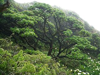
The Saint Helena scrub and woodlands ecoregion covers the volcanic island of Saint Helena in the South Atlantic Ocean. The island's remote location gave rise to many endemic species. First discovered and settled in the 1500s, the island has been degraded by human activities. Most of its native habitat has been destroyed, and many of its unique plants and animals are extinct or endangered.

Half Tree Hollow is the smallest by area of the eight districts of the island of Saint Helena, part of the British Overseas Territory of Saint Helena, Ascension and Tristan da Cunha in the South Atlantic Ocean. It is a suburb of Jamestown and is situated at the top of Ladder Hill which forms the southern side of the James Valley, at the base of which sits Jamestown. The hill was fortified in the late 1700s and Ladder Hill Fort was subsequently built. The village grew during the 1960s because the James Valley lacked any room for expansion.
The Legislative Council of Saint Helena has 15 members, 12 members elected for a four-year term by popular vote and three members ex officio. Members of the Council are referred to as Councillors and sometimes use the suffix "MLC", while the council itself is often referred to as "LegCo" by islanders officials.
Barren Ground is a settlement at the western end of the island of Saint Helena, north west of Blue Hill. It is administratively part of Blue Hill, but is locally seen as a distinct place.

Alarm Forest is the newest of the eight districts of the island of Saint Helena, part of the British Overseas Territory of Saint Helena, Ascension and Tristan da Cunha in the South Atlantic Ocean. It is located southeast of Jamestown, in the interior of the island, and is the only district to lack a coastline.

St. Paul's is one of eight districts of the island of Saint Helena, part of the British Overseas Territory of Saint Helena, Ascension and Tristan da Cunha in the South Atlantic Ocean. It is the second-most heavily populated district on the island and is located on its northwestern coast.

Saint Helena, Ascension and Tristan da Cunha is a British Overseas Territory located in the South Atlantic and consisting of the island of Saint Helena, Ascension Island, and the archipelago of Tristan da Cunha. Its name was Saint Helena and Dependencies until 1 September 2009, when a new constitution came into force giving the three islands equal status as three territories, with a grouping under the Crown.
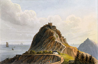
High Knoll Fort is a redoubt-style fort of the English East India Company on Saint Helena, an island and British overseas territory in the South Atlantic Ocean. High Knoll is 584 metres (1,916 ft) above sea level and is approximately one mile (1.6km) south of historic Lower Jamestown. Reopened on 18 December 2010, it is now a tourist attraction for visitors, especially those on the tourist ships that come in the summer.

The politics of Saint Helena, Ascension and Tristan da Cunha operate under the jurisdiction of the government of the United Kingdom. The three parts of the territory—Saint Helena, Ascension Island and Tristan da Cunha—effectively form an asymmetric federacy and collectively constitute one of United Kingdom's fourteen overseas territories.

Jacob's Ladder is a Grade I listed staircase leading from Jamestown, Saint Helena, up the side of Ladder Hill to Ladder Hill Fort. The name is a reference to the biblical Jacob's Ladder, a ladder extending to heaven.

Sandy Bay is one of eight districts of the island of Saint Helena, part of the British Overseas Territory of Saint Helena, Ascension and Tristan da Cunha in the South Atlantic Ocean. Located on the island's southeastern coast, it is sparsely populated and is a popular recreation site.

The Castle is the main government building of the British Overseas Territory of Saint Helena, Ascension and Tristan da Cunha, located in Jamestown on the island of Saint Helena. A Grade I-listed building, the oldest parts of the complex date to 1708, but it was largely reconstructed in the 1860s because of termite damage. It does not have the appearance of a typical castle, though historically the site was part of the East India Company fortifications of Jamestown.
Trade unions in Saint Helena emerged in the late 1950s in the flax industry and subsequently played a prominent role in the island's democratisation in the 1960s. The Saint Helena General Workers Union was the island's sole trade union throughout the latter half of the 20th century. In the 21st century, workers are mostly organised in the public sector in staff associations for nurses, teachers and public servants.
Asplenium haughtonii, also known as the Barn fern, is a species of fern in the family Aspleniaceae. It is native to Saint Helena.
Sir Thomas Oates, CMG, OBE was a British colonial administrator. He was Governor of Saint Helena from 1971 to 1976.

