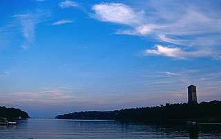
Sir Sandford Fleming Park is a 95-acre (38 ha) Canadian urban park located in the community of Jollimore in Halifax Regional Municipality. It is also known as Dingle Park which means wooded valley. The park was donated to the people of Halifax by Sir Sandford Fleming. The centrepiece of the park is an impressive tower that commemorates Nova Scotia's achievement of representative government in 1758. Constructed between 1908 and 1912, the Memorial Tower was erected during the same period of building other commemorative towers in the British Commonwealth, notably Cabot Tower in Bristol, England (1898) and Cabot Tower in St. John's (1900).

Halifax Chebucto is a provincial electoral district in Nova Scotia, Canada, that elects one member of the Nova Scotia House of Assembly.

Bedford is a provincial electoral district in Nova Scotia, Canada, that elects one member of the Nova Scotia House of Assembly. Its current Member of the Legislative Assembly is Kelly Regan.

Halifax Citadel-Sable Island is a provincial electoral district in Halifax, Nova Scotia, Canada, that elects one member of the Nova Scotia House of Assembly.
Halifax Atlantic is a provincial electoral district in Nova Scotia, Canada, that elects one member of the Nova Scotia House of Assembly.
Dartmouth East is a provincial electoral district in Nova Scotia, Canada, that elects one member of the Nova Scotia House of Assembly. The riding is located in the Dartmouth region of the Halifax RM.

Dartmouth North is a provincial electoral district in Dartmouth, Nova Scotia, Canada, that elects one member of the Nova Scotia House of Assembly.

Timberlea—Prospect is a provincial electoral district in Nova Scotia, Canada, that elects one member of the Nova Scotia House of Assembly. Its Member of the Legislative Assembly (MLA) since 2013 has been Iain Rankin of the Nova Scotia Liberal Party.
Hammonds Plains—Upper Sackville is a former provincial electoral district in Nova Scotia, Canada which existed from 2003-2013. It elected one member of the Nova Scotia House of Assembly. In its last configuration, the electoral district included those communities comprising the western suburbs of the Halifax Regional Municipality, namely Hammonds Plains, Yankeetown, Pockwock, Upper Sackville and Lucasville.

Dartmouth South is a provincial electoral district in Nova Scotia, Canada, that elects one member of the Nova Scotia House of Assembly. The riding is currently represented by Claudia Chender of the NDP.
Eastern Shore is a provincial electoral district in Nova Scotia, Canada, that elects one member of the Nova Scotia House of Assembly.
Halifax Cobequid was a provincial electoral district in Nova Scotia, Canada, that elected one member of the Nova Scotia House of Assembly. It was formed in 1967 from the former district of Halifax Northwest, and existed until 1978, when it was redistributed into four new districts: Sackville, Halifax Bedford Basin, Bedford-Musquodoboit Valley, and Cole Harbour.
Halifax County-Dartmouth was a provincial electoral district in Nova Scotia, Canada, that elected one member of the Nova Scotia House of Assembly. It existed from 1956 to 1967, at which point the district was reformed into Dartmouth North and Dartmouth South.
Halifax East was a provincial electoral district in Nova Scotia, Canada, that elected one member of the Nova Scotia House of Assembly. It was formed in1933 when Halifax County was divided into five distinct electoral districts. In 1966, it was renamed Halifax County East, and in 1967, its boundaries were reformed to create the current district of Halifax Eastern Shore.
Halifax North was a provincial electoral district in Nova Scotia, Canada, that elected one member of the Nova Scotia House of Assembly. It was formed in 1933 when Halifax County was divided into five distinct electoral districts. In 1966, Halifax North was divided into Halifax City Northeast and Halifax City Northwest. The following year, these districts were renamed to become Halifax Needham and Halifax Chebucto, respectively.
Halifax South was a provincial electoral district in Nova Scotia, Canada, that elected one member of the Nova Scotia House of Assembly. It was formed in 1933 when Halifax County was divided into five distinct districts. It was renamed Halifax City South in 1966, and its boundaries were reformed in 1967 to create the district of Halifax Cornwallis.
Halifax West was a provincial electoral district in Nova Scotia, Canada, that elected one member to the Nova Scotia House of Assembly. It was formed in 1933 when Halifax County was divided into five distinct electoral districts. In 1955, the district of Halifax Northwest was created from a portion of Halifax West. Following a name change in 1966 to Halifax County West, the district was redistributed entirely to create the current district of Halifax-St. Margaret's in 1967.
Halifax was a provincial electoral district in Nova Scotia, Canada, that elected three, and then five members to the Nova Scotia House of Assembly. It existed from 1867 to 1933, at which point Halifax County was divided into five separate electoral districts: Halifax South, Halifax Centre, Halifax North, Halifax East and Halifax West.

Halifax Armdale is a provincial electoral district in Nova Scotia, Canada, that elects one member of the Nova Scotia House of Assembly. This Halifax district covers the growing population of the Fairmount, Armdale and Cowie Hill areas. The northern boundary is Highway 102, the eastern boundary is Joseph Howe Drive and the Northwest Arm, while the southern boundary is Frog Pond Park in Armdale.

Clayton Park West is a provincial electoral district in Nova Scotia, Canada, that elects one member of the Nova Scotia House of Assembly.


