Hamill, South Dakota

Last updated

Hamill, South Dakota
CDP
Tripp County South Dakota Incorporated and Unincorporated areas Hamill Highlighted.svg
Location in Tripp County and the state of South Dakota
Coordinates: 43°35′38″N99°41′26″W / 43.59389°N 99.69056°W / 43.59389; -99.69056
CountryUnited States
State South Dakota
County Tripp
Area
[1]
  Total1.25 sq mi (3.25 km2)
  Land1.22 sq mi (3.16 km2)
  Water0.03 sq mi (0.08 km2)
Elevation
[2]
1,798 ft (548 m)
Population
 (2020) [3]
  Total14
  Density11.46/sq mi (4.42/km2)
Time zone UTC-6 (Central (CST))
  Summer (DST) UTC-5 (CDT)
ZIP code
57534
Area code 605
FIPS code 46-26660 [4]
GNIS feature ID2393037 [2]

Hamill is a rural hamlet in Tripp County, South Dakota, United States. The population was 14 at the 2020 census. [5] There is a post office at Hamill, also two churches and a community hall; otherwise, no businesses or services.

Contents

Demographics

Historical population
CensusPop.Note
2020 14
U.S. Decennial Census [6]

As of the census [4] of 2000, there were 11 people, 5 households, and 3 families residing in Hamill. The population density was 9.0 people per square mile (3.5/km2). There were 7 housing units at an average density of 5.7/sq mi (2.2/km2). The racial makeup of the CDP was 100.00% White.

There were 5 households, out of which 20.0% had children under the age of 18 living with them, 40.0% were married couples living together, and 40.0% were non-families. 40.0% of all households were made up of individuals, and 20.0% had someone living alone who was 65 years of age or older. The average household size was 2.20 and the average family size was 3.00.

In Hamill, the population was spread out, with 18.2% under the age of 18, 27.3% from 25 to 44, 9.1% from 45 to 64, and 45.5% who were 65 years of age or older. The median age was 62 years. For every 100 females, there were 83.3 males. For every 100 females age 18 and over, there were 80.0 males.

The median income for a household in Hamill was $42,500, and the median income for a family was $42,500. Males had a median income of $15,000 versus $16,250 for females. The per capita income for Hamill was $11,833. None of the population or families were below the poverty line.

History

The town was started in April 1909 on the east side of No Moccasin Lake. Originally named Roseland, [7] Hamill was renamed for Gail Hamill the pioneer merchant, postmaster and banker in town. [8] In 1909 the Milwaukee Road surveyed a route from Oacoma, South Dakota through Roseland and beyond but the line was never built. [9]

Carrie Ingalls (sister of Little House on the Prairie's Laura Ingalls Wilder) was transferred to the local newspaper; Roseland Review in 1910, from Pedro, South Dakota. [10] [11]

A census-designated place (CDP) was established in 1980 to include Hamill, from which the CDP derived its name. According to the United States Census Bureau, this CDP has a total area of 1.2 square miles (3.1 km2), of which 1.2 square miles (3.1 km2) is land and 0.04 square miles (0.10 km2) (2.40%) is water.

Related Research Articles

<span class="mw-page-title-main">Tripp County, South Dakota</span> County in South Dakota, United States

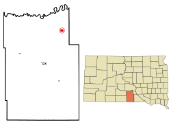
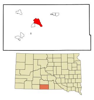
Tripp County is a county in the U.S. state of South Dakota. As of the 2020 census, the population was 5,624. Its county seat is Winner. The county was created in 1873, and was organized in 1909. It is named for lawyer, judge, and diplomat Bartlett Tripp.

<span class="mw-page-title-main">Roseland, Florida</span> Census-designated place in Florida, United States

Roseland is an unincorporated community and census-designated place (CDP) in Indian River County, Florida, United States. The population was 1,472 at the 2010 census, down from 1,775 at the 2000 census. It is part of the Sebastian–Vero Beach Metropolitan Statistical Area.
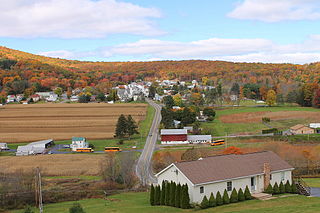
<span class="mw-page-title-main">Ingalls Park, Illinois</span> Census-designated place in Illinois, United States

Ingalls Park is a census-designated place and suburb of Joliet in Will County, Illinois, United States. The population was 3,314 at the 2010 census. The town consists of a small neighborhood and a few businesses between Joliet's Pilcher Park and Interstate 80. It is the nearest town to Chicagoland Speedway, which hosted the NASCAR Cup Series from 2001 to 2019.

<span class="mw-page-title-main">Fort Thompson, South Dakota</span> CDP in South Dakota, United States

Fort Thompson is a census-designated place (CDP) in Buffalo County, South Dakota, United States. The population was 1,282 at the 2010 census, making it the largest settlement on the Crow Creek Reservation.

<span class="mw-page-title-main">Marty, South Dakota</span> CDP in South Dakota, United States

Marty is a census-designated place (CDP) in southern Charles Mix County, South Dakota, United States. The population was 677 at the 2020 census.

<span class="mw-page-title-main">Bullhead, South Dakota</span> CDP in South Dakota, United States

Bullhead is a census-designated place (CDP) in Corson County, South Dakota, United States, within the Standing Rock Indian Reservation. The population was 348 at the 2010 census.

<span class="mw-page-title-main">La Plant, South Dakota</span> Census-designated place in South Dakota, United States

La Plant is a census-designated place (CDP) in Dewey County, South Dakota, United States. The population was 167 at the 2020 census. It is within the Cheyenne River Indian Reservation.

<span class="mw-page-title-main">Harrison, South Dakota</span> Census-designated place in South Dakota, United States

Harrison is an unincorporated community and census-designated place (CDP) in Douglas County, South Dakota, United States. The population was 55 at the 2020 census.

<span class="mw-page-title-main">St. Charles, South Dakota</span> CDP in South Dakota, United States

St. Charles or Saint Charles is a census-designated place (CDP) in Gregory County, South Dakota, United States. The population was 15 at the 2020 census.

<span class="mw-page-title-main">Tripp, South Dakota</span> City in South Dakota, United States

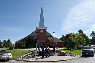
Tripp is a city in Hutchinson County, South Dakota, United States. The population was 575 in the 2020 census.

<span class="mw-page-title-main">De Smet, South Dakota</span> Town in South Dakota, United States

De Smet is a city in and the county seat of Kingsbury County, South Dakota, United States. The population was 1,089 at the 2010 census.

<span class="mw-page-title-main">North Spearfish, South Dakota</span> Census-designated place in South Dakota, United States

North Spearfish is a census-designated place (CDP) in Lawrence County, South Dakota, United States. The population was 2,366 at the 2020 census.

<span class="mw-page-title-main">Ashland Heights, South Dakota</span> CDP in South Dakota, United States

Ashland Heights is a census-designated place (CDP) and unincorporated community in Pennington County, South Dakota, United States. The population was 678 at the 2020 census.

<span class="mw-page-title-main">Colonial Pine Hills, South Dakota</span> CDP in South Dakota, United States

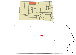
Colonial Pine Hills is a census-designated place (CDP) and unincorporated community in Pennington County, South Dakota, United States. The population was 1,903 at the 2020 census.

<span class="mw-page-title-main">Green Valley, South Dakota</span> CDP in South Dakota, United States

Green Valley is a census-designated place (CDP) and unincorporated community in Pennington County, South Dakota, United States. The population was 1,051 at the 2020 census.

<span class="mw-page-title-main">Keystone, South Dakota</span> Town in South Dakota, United States

Keystone is a town in the Black Hills region of Pennington County, South Dakota, United States. The population was 240 at the 2020 census. It had its origins in 1883 as a mining town, and has since transformed itself into a resort town, serving the needs of the millions of visitors to the Mount Rushmore National Memorial, which is located just beyond the town limits. Keystone was heavily damaged in the 1972 Black Hills flood.

<span class="mw-page-title-main">Rapid Valley, South Dakota</span> CDP in South Dakota, United States

Rapid Valley is a census-designated place (CDP) and unincorporated community in Pennington County, South Dakota, United States, and a suburb of Rapid City. The population was 8,098 at the 2020 census. Rapid Valley has been a retreat for people living in Rapid City due to its low crime, cheap land, and views of the Black Hills. Rapid Valley is home to many industrial and financial businesses, and is the headquarters for many corporations specializing in transport and engineering.

<span class="mw-page-title-main">Oglala, South Dakota</span> CDP in South Dakota, United States

Oglala is a census-designated place (CDP) in West Oglala Lakota Unorganized Territory equivalent, Oglala Lakota County, South Dakota, United States. The population was 1,282 at the 2020 census. Its location is in the northwest of the Pine Ridge Indian Reservation.

<span class="mw-page-title-main">Pine Ridge, South Dakota</span> CDP in South Dakota, United States

Pine Ridge is a census-designated place (CDP) and the most populous community in Oglala Lakota County, South Dakota, United States. The population was 3,138 at the 2020 census. It is the tribal headquarters of the Oglala Sioux Tribe on the Pine Ridge Indian Reservation.

<span class="mw-page-title-main">Rosebud, South Dakota</span> CDP in South Dakota, United States

Rosebud also Sicanġu is a census-designated place (CDP) in Todd County, South Dakota, United States. The population was 1,455 at the 2020 census.
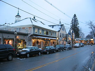
References

  1. "ArcGIS REST Services Directory". United States Census Bureau. Retrieved October 15, 2022.
  2. 1 2 U.S. Geological Survey Geographic Names Information System: Hamill, South Dakota
  3. "Census Population API". United States Census Bureau. Retrieved October 15, 2022.
  4. 1 2 "U.S. Census website". United States Census Bureau . Retrieved January 31, 2008.
  5. "U.S. Census Bureau: Hamill CDP, South Dakota". www.census.gov. United States Census Bureau. Retrieved December 23, 2021.
  6. "Census of Population and Housing". Census.gov. Retrieved June 4, 2016.
  7. Hamill, Tripp County
  8. Federal Writers' Project (1940). South Dakota place-names, v.1–3. University of South Dakota. p. 40.
  9. Linnaus, Dr. Vernon F and Bartels, Michael M.. Rails to the Rosebud. South Platte Press, 2008, p. 41.
  10. Carrie Ingalls profile on Keystone Area Historical Society Official Homepage
  11. Carrie Ingalls on littlehousediscussion.blogspot.com