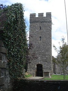
Hammam Melouane | |
|---|---|
Commune and town | |
| Country | |
| Province | Blida Province |
| Population (1998) | |
| • Total | 4,551 |
| Time zone | UTC+1 (CET) |
Hammam Melouane is a town and commune in Blida Province, Algeria. According to the 1998 census it has a population of 4,551. [1]
Hammam Melouane | |
|---|---|
Commune and town | |
| Country | |
| Province | Blida Province |
| Population (1998) | |
| • Total | 4,551 |
| Time zone | UTC+1 (CET) |
Hammam Melouane is a town and commune in Blida Province, Algeria. According to the 1998 census it has a population of 4,551. [1]

The House of the Vestal Virgins was the residence of Vestal Virgins, located behind the circular Temple of Vesta at the eastern edge of the Roman Forum, between the Regia and the Palatine Hill. The domus publica, where the Pontifex Maximus dwelled, was located near the Atrium until that role was assumed by the emperors.

Evinston is an unincorporated community in Alachua and Marion counties, Florida, United States.
Accomac is a community in Hellam Township, York County, Pennsylvania, on the south bank of the Susquehanna River. It is located at coordinates 40°02′42″N76°33′50″W at an elevation of 271 ft.

Cilycwm is a village and parish located in Carmarthenshire, Wales. The community population taken at the 2011 census was 487.
Pea Ridge is community in Santa Rosa County, Florida, United States, located along U.S. Highway 90. It is located near Milton. It was designated a Census-designated place (CDP) by the Census Bureau after the 2010 census. The CDP had a total area of 2.82 square miles (7.3 km2) and a population 3,587 in 2010.
Dąbie is a village in the administrative district of Gmina Bytów, within Bytów County, Pomeranian Voivodeship, in northern Poland. It lies approximately 8 kilometres (5 mi) north of Bytów and 77 km (48 mi) west of the regional capital Gdańsk.
Milanlı is a village in the Qubadli Rayon of Azerbaijan.
Rozkochów is a village in the administrative district of Gmina Babice, within Chrzanów County, Lesser Poland Voivodeship, in southern Poland. It lies approximately 4 kilometres (2 mi) south-east of Babice, 12 km (7 mi) south-east of Chrzanów, and 33 km (21 mi) west of the regional capital Kraków.
Fidor is a village in the administrative district of Gmina Końskie, within Końskie County, Świętokrzyskie Voivodeship, in south-central Poland. It lies approximately 6 kilometres (4 mi) north-east of Końskie and 40 km (25 mi) north of the regional capital Kielce.
Łąkie is a settlement in the administrative district of Gmina Polanów, within Koszalin County, West Pomeranian Voivodeship, in northwestern Poland.

Siedlice is a village in the administrative district of Gmina Radowo Małe, within Łobez County, West Pomeranian Voivodeship, in north-western Poland. It lies approximately 5 kilometres (3 mi) south-east of Radowo Małe, 9 km (6 mi) west of Łobez, and 64 km (40 mi) east of the regional capital Szczecin.

Operation Rhino was a raid led by the United States Army's 75th Ranger Regiment, who were led by Colonel Joseph Votel, and other SOCOM units on several Taliban targets in and around Kandahar, Afghanistan during the invasion of Afghanistan at the start of the War in Afghanistan.
The Parit Buntar railway station is a Malaysian train station located at and named after the town of Parit Buntar, Perak.
Jastrebac is a village in the municipality of Vladičin Han, Serbia. According to the 2002 census, the village has a population of 221 people.
Odyssey High School was a high school located at 95 G St, South Boston, Massachusetts 02127. It is one third of the old South Boston High. It was then shut down, after they lost their head master.
County Line is an unincorporated community in the northwest corner of Fulton County, Arkansas United States. The community church is in Fulton County, adjacent to the county line and the County Line Cemetery is across the line to the west in northeast Baxter County. The community lies approximately one-half mile to the southeast of Bennetts Bayou.
Gozo College Boys' Secondary School is a public school located Victoria, Gozo.
The Diocese of Mpwapwa is a central diocese in the Anglican Church of Tanzania: its current bishop is the Most Reverend Jacob Chimeledya.

The Tasek Gelugor railway station is a Malaysian train station located at and named after the town of Tasek Gelugor, Penang.
Coordinates: 36°29′12″N3°02′42″E / 36.48667°N 3.04500°E