The geography of France consists of a terrain that is mostly flat plains or gently rolling hills in the north and west and mountainous in the south and the east. Metropolitan France has a total size of 551,695 km2 (213,011 sq mi). It is the third largest country in Europe after Russia and Ukraine.
Manđelos is a village located in the Sremska Mitrovica municipality, in the Syrmia District of Vojvodina, Serbia. The village has a Serb ethnic majority and its population numbering 1,533 people.

Płóczki Górne is a village in the administrative district of Gmina Lwówek Śląski, within Lwówek Śląski County, Lower Silesian Voivodeship, in south-western Poland. Prior to 1945 it was in Germany.
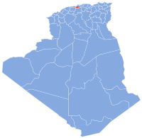
Bougara is a town in the Mitidja plain in Algeria, about 20 kilometers due south of Algiers. Located on the N29, the main road between Blida and Larbaâ, it is the capital of Bougara District, in Blida Province. In 1998 it had a population of 34,100.
Budíškovice is a village in the Jindřichův Hradec District of the Czech Republic.
Wola Nakonowska is a village in the administrative district of Gmina Choceń, within Włocławek County, Kuyavian-Pomeranian Voivodeship, in north-central Poland. It lies approximately 14 kilometres (9 mi) south of Włocławek and 64 km (40 mi) south-east of Toruń.
Szopowe is a village in the administrative district of Gmina Józefów, within Biłgoraj County, Lublin Voivodeship, in eastern Poland. It lies approximately 7 kilometres (4 mi) north-east of Józefów, 25 km (16 mi) east of Biłgoraj, and 88 km (55 mi) south-east of the regional capital Lublin.
Tuszów is a village in the administrative district of Gmina Jabłonna, within Lublin County, Lublin Voivodeship, in eastern Poland. It lies approximately 4 kilometres (2 mi) west of Jabłonna and 19 km (12 mi) south of the regional capital Lublin.
Dobrochy is a village in the administrative district of Gmina Rutki, within Zambrów County, Podlaskie Voivodeship, in north-eastern Poland. It lies approximately 22 kilometres (14 mi) north-east of Zambrów and 43 km (27 mi) west of the regional capital Białystok.

Czarna is a village in the administrative district of Gmina Uście Gorlickie, within Gorlice County, Lesser Poland Voivodeship, in southern Poland, close to the border with Slovakia. It lies approximately 5 kilometres (3 mi) west of Uście Gorlickie, 15 km (9 mi) south-west of Gorlice, and 102 km (63 mi) south-east of the regional capital Kraków.
Kadel is a village in Bajhang District in the Seti Zone of north-western Nepal. At the time of the 1991 Nepal census it had a population of 3,816 and had 693 houses in the village.
Chrząblice is a village in the administrative district of Gmina Brudzew, within Turek County, Greater Poland Voivodeship, in west-central Poland. It lies approximately 5 kilometres (3 mi) west of Brudzew, 8 km (5 mi) north of Turek, and 116 km (72 mi) east of the regional capital Poznań.
Smolina is a village in the administrative district of Gmina Brudzew, within Turek County, Greater Poland Voivodeship, in west-central Poland. It lies approximately 5 kilometres (3 mi) west of Brudzew, 8 km (5 mi) north of Turek, and 116 km (72 mi) east of the regional capital Poznań.
Prusowy Borek is a village in the administrative district of Gmina Szczytno, within Szczytno County, Warmian-Masurian Voivodeship, in northern Poland. It lies approximately 8 kilometres (5 mi) south-east of Szczytno and 48 km (30 mi) south-east of the regional capital Olsztyn.

Mianning County is a county of Sichuan Province, China. It is under the administration of the Liangshan Yi Autonomous Prefecture.
Krasnaya Zarya is the name of several rural localities in Russia.
Maslovsky, Maslovskaya, or Maslovskoye is the name of several rural localities in Russia.
Kafr Hind is a Syrian village located in Salqin Nahiyah in Harem District, Idlib. According to the Syria Central Bureau of Statistics (CBS), Kafr Hind had a population of 1073 in the 2004 census.