Hamry (Chrudim District)

Last updated
Hamry
Hamry obecni urad.jpg
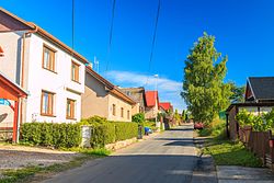
Main street with the municipal office
Hamry (Chrudim District) Flag.jpg
Hamry (Chrudim District) CoA.png
Relief Map of Czech Republic.png
Red pog.svg
Hamry
Location in the Czech Republic
Coordinates: 49°44′20″N15°55′35″E / 49.73889°N 15.92639°E / 49.73889; 15.92639
CountryFlag of the Czech Republic.svg  Czech Republic
Region Pardubice
District Chrudim
First mentioned1353
Area
  Total
3.82 km2 (1.47 sq mi)
Elevation
585 m (1,919 ft)
Population
 (2025-01-01) [1]
  Total
226
  Density59/km2 (150/sq mi)
Time zone UTC+1 (CET)
  Summer (DST) UTC+2 (CEST)
Postal code
539 01
Website www.hamry.cz

Hamry is a municipality and village in Chrudim District in the Pardubice Region of the Czech Republic. It has about 200 inhabitants.

Contents

Demographics

Historical population
YearPop.±%
1869531    
1880530−0.2%
1890536+1.1%
1900559+4.3%
1910607+8.6%
1921559−7.9%
1930597+6.8%
1950395−33.8%
1961368−6.8%
1970320−13.0%
1980262−18.1%
1991219−16.4%
2001237+8.2%
2011259+9.3%
2021221−14.7%
Source: Censuses [2] [3]

References

  1. "Population of Municipalities – 1 January 2025". Czech Statistical Office. 2025-05-16.
  2. "Historický lexikon obcí České republiky 1869–2011" (in Czech). Czech Statistical Office. 2015-12-21.
  3. "Population Census 2021: Population by sex". Public Database. Czech Statistical Office. 2021-03-27.