Svratouch

Last updated
Svratouch
Lovecky zamek Karlstejn, CZ200704-R-045.jpg
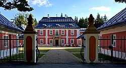
Karlštejn hunting castle
Svratouch flag.jpg
Svratouch CoA.jpg
Relief Map of Czech Republic.png
Red pog.svg
Svratouch
Location in the Czech Republic
Coordinates: 49°43′28″N16°2′3″E / 49.72444°N 16.03417°E / 49.72444; 16.03417
CountryFlag of the Czech Republic.svg  Czech Republic
Region Pardubice
District Chrudim
First mentioned1392
Area
  Total
12.72 km2 (4.91 sq mi)
Elevation
655 m (2,149 ft)
Population
 (2025-01-01) [1]
  Total
924
  Density73/km2 (190/sq mi)
Time zone UTC+1 (CET)
  Summer (DST) UTC+2 (CEST)
Postal code
539 42
Website www.svratouch.cz

Svratouch is a municipality and village in Chrudim District in the Pardubice Region of the Czech Republic. It has about 900 inhabitants.

Contents

Administrative division

Svratouch consists of two municipal parts (in brackets population according to the 2021 census): [2]

Geography

Svratouch is located about 30 kilometres (19 mi) southeast of Chrudim and 38 km (24 mi) southeast of Pardubice. It lies mostly in the Upper Svratka Highlands, only the western part of the municipal territory extends into the Iron Mountains. The highest point is the hill Karlštejn at 783 m (2,569 ft) above sea level. The municipality lies within the Žďárské vrchy Protected Landscape Area.

Climate

Climate data for Svratouch (1991–2020)
MonthJanFebMarAprMayJunJulAugSepOctNovDecYear
Record high °C (°F)13.3
(55.9)
15.1
(59.2)
18.9
(66.0)
24.3
(75.7)
29.6
(85.3)
31.8
(89.2)
33.2
(91.8)
33.7
(92.7)
30.3
(86.5)
22.0
(71.6)
16.1
(61.0)
11.8
(53.2)
33.7
(92.7)
Mean daily maximum °C (°F)−0.6
(30.9)
0.7
(33.3)
5.1
(41.2)
11.4
(52.5)
16.0
(60.8)
19.3
(66.7)
21.6
(70.9)
21.7
(71.1)
16.1
(61.0)
10.4
(50.7)
4.3
(39.7)
0.1
(32.2)
10.5
(50.9)
Daily mean °C (°F)−2.8
(27.0)
−1.9
(28.6)
1.5
(34.7)
6.9
(44.4)
11.5
(52.7)
14.9
(58.8)
16.8
(62.2)
16.8
(62.2)
11.9
(53.4)
7.0
(44.6)
2.1
(35.8)
−1.9
(28.6)
6.9
(44.4)
Mean daily minimum °C (°F)−5.0
(23.0)
−4.3
(24.3)
−1.3
(29.7)
3.2
(37.8)
7.4
(45.3)
10.8
(51.4)
12.7
(54.9)
12.7
(54.9)
8.7
(47.7)
4.4
(39.9)
0.1
(32.2)
−4.0
(24.8)
3.8
(38.8)
Record low °C (°F)−23.7
(−10.7)
−20.4
(−4.7)
−16.3
(2.7)
−9.5
(14.9)
−3.9
(25.0)
1.3
(34.3)
4.2
(39.6)
4.4
(39.9)
−0.9
(30.4)
−7.3
(18.9)
−14.0
(6.8)
−18.9
(−2.0)
−23.7
(−10.7)
Average precipitation mm (inches)44.7
(1.76)
40.0
(1.57)
59.9
(2.36)
47.6
(1.87)
85.2
(3.35)
91.4
(3.60)
102.8
(4.05)
90.8
(3.57)
74.1
(2.92)
53.1
(2.09)
47.0
(1.85)
48.1
(1.89)
784.7
(30.89)
Average precipitation days (≥ 1.0 mm)10.69.211.38.210.710.911.19.69.19.09.110.8119.6
Mean monthly sunshine hours 54.676.9121.4180.2212.5213.2228.2229.7157.7108.149.144.31,675.9
Source: NOAA [3]

History

The first written mention of Svratouch is from 1392. Until the establishment of an independent municipality in 1848, the village belonged to the Rychmburk estate. [4]

Demographics

Historical population
YearPop.±%
18691,609    
18801,606−0.2%
18901,561−2.8%
19001,521−2.6%
19101,558+2.4%
YearPop.±%
19211,489−4.4%
19301,375−7.7%
19501,049−23.7%
19611,137+8.4%
19701,069−6.0%
YearPop.±%
19801,014−5.1%
1991926−8.7%
2001899−2.9%
2011873−2.9%
2021883+1.1%
Source: Censuses [5] [6]

Transport

There are no railways or major roads passing through the municipality.

Sights

The most important monument is the hunting castle in Karlštejn. It was built in the Baroque style in 1770–1775. Today it serves as a hotel and restaurant. [7]

See also

References

  1. "Population of Municipalities – 1 January 2025". Czech Statistical Office. 2025-05-16.
  2. "Public Census 2021 – basic data". Public Database (in Czech). Czech Statistical Office. 2022.
  3. "World Meteorological Organization Climate Normals for 1991-2020 — Svratouch". National Oceanic and Atmospheric Administration. Retrieved 2024-01-12.
  4. "Historie obce" (in Czech). Obec Svratouch. Retrieved 2024-02-23.
  5. "Historický lexikon obcí České republiky 1869–2011" (in Czech). Czech Statistical Office. 2015-12-21.
  6. "Population Census 2021: Population by sex". Public Database. Czech Statistical Office. 2021-03-27.
  7. "Zámek – lovecký zámeček" (in Czech). National Heritage Institute. Retrieved 2024-02-23.