
Dartmoor is an upland area in southern Devon, South West England. The moorland and surrounding land has been protected by National Park status since 1951. Dartmoor National Park covers 954 km2 (368 sq mi).

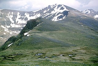
High Willhays, or according to some authorities High Willes, is the highest point on Dartmoor, Devon, at 621 metres above sea level, and the highest point in Southern England.

Golden Cap is a hill and cliff situated on the English Channel coast between Bridport and Charmouth in Dorset, England. At 191 metres (627 ft), it is arguably the highest point near the south coast of Great Britain and is visible for tens of miles along the coastline. It is accessible via a coastal footpath from Seatown, and takes around 40 minutes to reach the summit.

The Erme is a river in south Devon, England. From its source on Dartmoor it flows in a generally southerly direction past some of the best-preserved archaeological remains on the moor. It leaves the moor at the town of Ivybridge and continues southward, passing the settlements of Ermington, Modbury and Holbeton. Near Holbeton it becomes a ria and empties into the English Channel in Bigbury Bay, between the rivers Yealm and Avon.

Aran Fawddwy is a mountain in southern Snowdonia, Wales, United Kingdom. It is the highest point of the historic county of Merionethshire. It is the highest peak in the Aran mountain range, the only peak in Wales outside North Snowdonia above 900m, and higher than anywhere in the United Kingdom outside Northern Snowdonia, the Scottish Highlands and the Lake District. The nearest small settlements to the mountain are Dinas Mawddwy to the south, Llanymawddwy to the southeast, Llanuwchllyn on the shores of Bala Lake to the north, and Rhydymain to the west. The nearest settlements with around 2,000 people are Bala and Dolgellau. On the eastern slopes of Aran Fawddwy is the small lake named Creiglyn Dyfi, the source of the River Dyfi. Its sister peak is Aran Benllyn at 885 metres (2,904 ft). There is also a middle peak: Erw y Ddafad-ddu.
Carn Eighe is a mountain in the Northwest Highlands of Scotland. Rising to 1,183 metres (3,881 ft) above sea level, it is the highest mountain in Scotland north of the Great Glen, the twelfth-highest in the British Isles, and, in terms of relative height, it is the second-tallest mountain in the British Isles after Ben Nevis. Carn Eighe lies between Glen Affric and Loch Mullardoch, and is at the heart of a massif along with its twin peak, the 1,181-metre (3,875 ft) Mam Sodhail.

Bovey Tracey is a town and civil parish in Devon, England, on the edge of Dartmoor, its proximity to which gives rise to the slogan used on the town's boundary signs, "The Gateway to the Moor". It is often known locally as "Bovey". It is about 10 miles south-west of Exeter and lies on the A382 road, about halfway between Newton Abbot and Moretonhampstead. The village is at the centre of the electoral ward of Bovey. At the 2011 census the population of this ward was 7,721.

The mountains and hills of the British Isles are categorised into various lists based on different combinations of elevation, prominence, and other criteria such as isolation. These lists are used for peak bagging, whereby hillwalkers attempt to reach all the summits on a given list, the oldest being the 282 Munros in Scotland, created in 1891.

Yes Tor is the second highest point on Dartmoor, Devon, South West England, at 619 metres (2,031 ft) above sea level. It is one of only two wholly English peaks south of the Peak District National Park—the other being nearby High Willhays—that are above 2,000 feet (610 m).

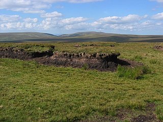
Cranmere Pool is a small depression within a peat bog in the northern half of Dartmoor, Devon, England, at grid reference SX604858. It lies 560 metres (1,840 ft) above sea level on the western flank of Hangingstone Hill, close to the source of the West Okement River, about 500 metres (550 yd) north west of the source of the East Dart River, and about the same distance west of the River Taw's source.

Margery Hill is a 546-metre (1,791 ft) hill on the Howden Moors in South Yorkshire, England. It lies towards the northern boundary of the Peak District National Park, between Langsett Reservoir to the northeast and Howden Reservoir to the southwest. The area is managed by the National Trust as part of their High Peak Estate.

Eldon Hill is a hill in the Peak District National Park in the county of Derbyshire, England, 4 kilometres (2.5 mi) southwest of the village of Castleton. It is a 470-metre (1,540 ft) limestone hill whose pastureland is used for rough grazing, although a large proportion has been lost to limestone quarrying. It lies within the Castleton Site of Special Scientific Interest. Eldon Hill was formed when a bed of pure limestone was squeezed and upfolded by geological forces to form a dome; it is the highest limestone hill north of the River Wye.

The mountains and hills of England comprise very different kinds of terrain, from a mountain range which reaches almost 1,000 metres high, to several smaller areas of lower mountains, foothills and sea cliffs. Most of the major upland areas have been designated as Areas of Outstanding Natural Beauty (AONB) or national parks. The highest and most extensive areas are in the north and west, while the midlands, south-east and east of the country tend to be low-lying.

Hookney Tor is a tor, situated on Dartmoor in Devon, England.

Cosdon Hill, also called Cosdon Beacon, or Cawsand Beacon, is one of the highest hills on Dartmoor, in Devon, England. It has numerous traces of prehistoric occupation.

Brown Knoll is one of the highest hills in the Peak District in central England. It rises to a height of 569 metres (1,867 ft) above the head of the Edale valley and about 3 kilometres (1.9 mi) south-southwest of the Peak's highest point, Kinder Scout.
Cut Hill is a hill in North Dartmoor in the southwest English county of Devon. At 603 metres high, it is the joint third highest peak in Devon and Dartmoor, together with Hangingstone Hill, which lies around 4 kilometres to the northeast.
Amicombe Hill, also known as the Devil's Dome, is a hill in North Dartmoor in the southwest English county of Devon. At 584 metres high, it is the sixth highest peak in Devon and Dartmoor.

Snowdon is a hill in Devon which at 495 m (1,624 ft) forms the second highest peak on the Southern moor of Dartmoor. The summit is the site of four Bronze Age ritual cairns, and the ground here shows evidence of being worked for peat.
