
Dartmoor is an upland area in southern Devon, South West England. The moorland and surrounding land has been protected by National Park status since 1951. Dartmoor National Park covers 954 km2 (368 sq mi).

Sabine Baring-Gould of Lew Trenchard in Devon, England, was an Anglican priest, hagiographer, antiquarian, novelist, folk song collector and eclectic scholar. His bibliography consists of more than 1,240 publications, though this list continues to grow.
Okehampton is a town and civil parish in West Devon in the English county of Devon. It is situated at the northern edge of Dartmoor, and had a population of 5,922 at the 2011 census. Two electoral wards are based in the town. Their joint population at the same census was 7,500.

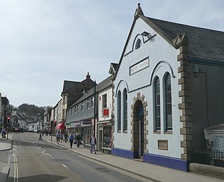
Moretonhampstead is a market town, parish and ancient manor in Devon, situated on the north-eastern edge of Dartmoor, within the Dartmoor National Park. The parish now includes the hamlet of Doccombe, and it is surrounded clockwise from the north by the parishes of Drewsteignton, Dunsford, Bridford, Bovey Tracey, Lustleigh, North Bovey and Chagford.

The River Teign is a river in the county of Devon, England. It is 31 mi (50 km) long and rises on Dartmoor, becomes an estuary just below Newton Abbot and reaches the English Channel at Teignmouth.
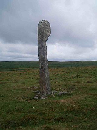
Drizzlecombe or Thrushelcombe is an area of Dartmoor in the county of Devon, England, containing a number of Bronze Age stone rows, cairns and menhirs.
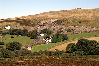
Merrivale is a locality in western Dartmoor, in the West Devon district of Devon, England. It is best known for the nearby series of Bronze Age megalithic monuments to the south and a former granite quarry.

Dartmeet is a popular tourist spot in the centre of Dartmoor, Devon, England at grid reference SX672731.

The Erme is a river in south Devon, England. From its source on Dartmoor it flows in a generally southerly direction past some of the best-preserved archaeological remains on the moor. It leaves the moor at the town of Ivybridge and continues southward, passing the settlements of Ermington, Modbury and Holbeton. Near Holbeton it becomes a ria and empties into the English Channel in Bigbury Bay, between the rivers Yealm and Avon.

Devon is a county in south west England, bordering Cornwall to the west with Dorset and Somerset to the east. There is evidence of occupation in the county from Stone Age times onward. Its recorded history starts in the Roman period when it was a civitas. It was then a separate kingdom for a number of centuries until it was incorporated into early England. It has remained a largely agriculture based region ever since though tourism is now very important.

Bovey Tracey is a town and civil parish in Devon, England, on the edge of Dartmoor, its proximity to which gives rise to the slogan used on the town's boundary signs, "The Gateway to the Moor". It is often known locally as "Bovey". It is about 10 miles south-west of Exeter and lies on the A382 road, about halfway between Newton Abbot and Moretonhampstead. The village is at the centre of the electoral ward of Bovey. At the 2011 census the population of this ward was 7,721.

Two Bridges is an isolated location on the river West Dart in the heart of Dartmoor National Park in Devon, England. It is situated around 2.5 km (1.6 mi) northeast of Princetown at the intersection of the two roads that cross Dartmoor: one is the old turnpike road which was built across Dartmoor in the late 18th century ; the other is the B3357.

The Dartmoor crosses are a series of stone crosses found in Dartmoor National Park in the centre of Devon, England. Many of them are old navigational aids, needed because of the remoteness of the moorland and its typically bad weather. Some mark medieval routes between abbeys. Other crosses were erected as memorials, for prayer, as town or market crosses, in churchyards, and as boundary markers. The crosses were erected over a long period of time, some as recently as 100 years ago, the earliest probably almost 1,000 years ago.

Dartmoor kistvaens are burial tombs or cists from the late Neolithic and early Bronze Age, i.e. from c. 2500 BC to c. 1500 BC. Kistvaens have been found in many places, including Dartmoor, a 954 km2 area of moorland in south Devon, England. The box-like stone tombs were created when the ancient people of the area lived in hut circles. Cists are often to be found in the centre of a cairn circle although some appear solitary which could be the result of the loss of an original slight mound. There are over 180 known cists on Dartmoor although there could be up to 100 that remain buried underneath unexplored cairns. In the South West there are no cists to be found on the Quantock Hills, only 2 to be found on Exmoor and 58 to be found on Bodmin Moor. The Dartmoor cists are unique in that about 94% have the longer axis of the tomb orientated in a NW/SE direction It appears that Dartmoor cists were positioned in such a way that the deceased were facing the Sun.

The county of Somerset is in South West England, bordered by the Bristol Channel and the counties of Bristol and Gloucestershire to the north, and Wiltshire to the east, Dorset to the south, and Devon to the west. The climate, influenced by its proximity to the Atlantic Ocean and the prevailing westerly winds, tends to be mild, damp and windy.

Hookney Tor is a tor, situated on Dartmoor in Devon, England.

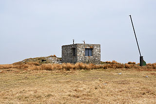
Cosdon Hill, also called Cosdon Beacon, or Cawsand Beacon, is one of the highest hills on Dartmoor, in Devon, England. It has numerous traces of prehistoric occupation.
Hangingstone Hill is a hill in North Dartmoor in the southwest English county of Devon. At 603 metres high, it is the joint third highest peak in Devon and Dartmoor, together with Cut Hill, which lies around 4 kilometres to the southwest.
Amicombe Hill, also known as the Devil's Dome, is a hill in North Dartmoor in the southwest English county of Devon. At 584 metres high, it is the sixth highest peak in Devon and Dartmoor.
