Hardeol

Last updated

Hardeol
Der Szurdse Kund aus Suden mit der Morane des Milam-Gletschers.jpg
Hardeol (left) and Tirsuli I, photo by Kurt Boeck  in 1890
Highest point
Elevation 7,151 m (23,461 ft)
Prominence 1,300 m (4,300 ft) [1]
Coordinates 30°33′36″N80°00′36″E / 30.56000°N 80.01000°E / 30.56000; 80.01000 Coordinates: 30°33′36″N80°00′36″E / 30.56000°N 80.01000°E / 30.56000; 80.01000 [2]
Geography
India relief location map.jpg
Red triangle with thick white border.svg
Hardeol
Location in northern India
Location Pithoragarh, Uttarakhand, India
Parent range Kumaon Himalaya
Geology
Mountain type ert56y
Climbing
First ascent 31 May 1978 by Indo-Tibetan Border Police Expedition

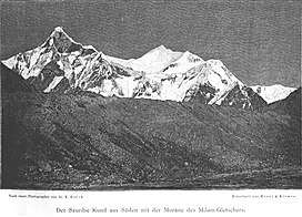
Hardeol or 'Temple of God' is one of the major peaks of the Kumaon Himalaya. It is the highest peak on the northern side of the ring of peaks guarding the Nanda Devi Sanctuary, and lies at the northeast corner of this ring. It is situated at the northern end of the Milam valley, in the Pithoragarh district of Uttarakhand, India. To its immediate north lies Trishuli, and just south is Rishi Pahar, on a north-south trending ridge leading eventually to Nanda Devi East. Hardeol is also known as Trishuli South.

After a reconnaissance in 1939 and a few serious attempts starting in 1967, the first ascent of Hardeol was made by a team from the Indo-Tibetan Border Police on 31 May 1978, led by S. P. Mulasi, climbing from the ridge connecting the peak to Trishuli. Only one further ascent, in 1991, is listed in the Himalayan Index. [2] This ascent, by a large expedition from the Indian Border Security Force, put five members on the summit on 24 September. [3]

The best approach to Hardeol is from the eastern side, through the Ikualari glacier and thence to the right, up the Trishuli valley towards the Hardeol icefall. The nearest road to Hardeol is Munsiyari.

Related Research Articles

<span class="mw-page-title-main">Nanda Devi</span> Second-highest mountain in India

Nanda Devi is the second-highest mountain in India, after Kangchenjunga, and the highest located entirely within the country. It is the 23rd-highest peak in the world.

<span class="mw-page-title-main">Kamet</span> Mountain in Uttarakhand, India

Kamet is the second highest mountain in the Garhwal region of Uttarakhand, India, after Nanda Devi. It lies in the Chamoli District of Uttarakhand. Its appearance resembles a giant pyramid topped by a flat summit area with two peaks.

Milam Glacier is a major glacier of the Kumaon Himalaya.

<span class="mw-page-title-main">Tirsuli</span>

Tirsuli is a Himalayan mountain peak in the Pithoragarh district of Uttarakhand, India. It is part of the complex of mountains, including Tirsuli West, Hardeol, Dunagiri, Changabang, and Kalanka, which make up the northeast wall of the Nanda Devi Sanctuary, in the Garhwal Himalaya. It rises at the northern end of the Johar Valley, which drains into the Gori Ganga. This peak should not be confused with nearby Trisul, which is on the southwest side of the Sanctuary.

<span class="mw-page-title-main">Nanda Kot</span>

Nanda Kot is a mountain peak of the Himalaya range located in the Pithoragarh district of Uttarakhand state in India. It lies in the Kumaon Himalaya, just outside the ring of peaks enclosing the Nanda Devi Sanctuary, 15 kilometres (9 mi) southeast of Nanda Devi itself. The name Nanda Kot literally means "Nanda's Fortress" and refers to the abode of one of the sacred forms of the Hindu Goddess Parvati who in legend has made her sanctuary amongst the ring of lofty mountains in the region.

Rishi Pahar is a Himalayan mountain peak, located in the Pithoragarh district of Uttarakhand state in India. It lies at the northeast corner of the ring of peaks surrounding the Nanda Devi Sanctuary, and on the eastern rim of the Nanda Devi Biosphere Reserve, just south of Trishuli and Hardeol. The Milam Glacier lies on its east flank. It marks the triple divide between the Milam, Dunagiri, and Uttari Rishi Ganga valleys. Rishi Pahar means 'The Peak of Saint' in Hindi.

The Nanda Devi National Park or Nanda Devi Biosphere Reserve, established in 1982 is a national park situated around the peak of Nanda Devi in Chamoli Garhwal district of Uttarakhand, in northern India. The entire park lies at an elevation of more than 3,500 m (11,500 ft) above mean sea level.

Tirsuli West, or Trishuli West, is a Himalayan mountain peak in the Chamoli district of Uttarakhand, India. It is part of the complex of mountains, including Tirsuli, Hardeol, Dunagiri, Changabang, and Kalanka, which make up the northeast wall of the Nanda Devi Sanctuary, in the Garhwal Himalaya. It lies very near both Tirsuli and Hardeol at the north end of the Johar Valley.

<span class="mw-page-title-main">Trisul</span> Mountain in Uttarakhand, india

Trisul is a group of three Himalayan mountain peaks of western Kumaun, Uttarakhand, with the highest reaching 7120m. The three peaks resemble a trident - in Sanskrit, Trishula, trident, is the weapon of Shiva. The Trishul group forms the southwest corner of the ring of peaks enclosing the Nanda Devi Sanctuary, about 15 kilometres (9 mi) west-southwest of Nanda Devi itself. The main peak, Trisul I, was the first peak over 7,000 m (22,970 ft) to have ever been climbed, in 1907.

<span class="mw-page-title-main">Nilkantha (mountain)</span>

Nilkantha is a major peak of the Garhwal division of the Himalayas, in the Uttarakhand region of the Indian state of Uttarakhand. Although substantially lower than the highest peaks of the region, it towers dramatically over the valley of the Alaknanda River and rises 3,474 metres (11,398 ft) above the Hindu pilgrimage site of Badrinath, only 9 km (6 mi) to the east. Frank Smythe described the peak as "second only to Siniolchu in Himalayan beauty."

<span class="mw-page-title-main">Gori Ganga</span> River in Uttarakhand, India

Gori Ganga is a river in the Munsiari tehsil of the Pithoragarh District, part of the state of Uttarakhand in northern India. Its principal source is the Milam Glacier, just northeast of Nanda Devi along with the Glaciers of the Ralam River, and the Pyunshani and Uttari & Dakshini Balati Glaciers that lie on the western face of the Panchachuli Peaks.

<span class="mw-page-title-main">Dunagiri (mountain)</span>

Dunagiri is one of the high peaks of the Chamoli District Himalayas in the northern Indian state of Uttarakhand. It lies at the northwest corner of the Sanctuary Wall, A ring of peaks surrounding Nanda Devi and enclosing the Nanda Devi Sanctuary.

<span class="mw-page-title-main">Sunanda Devi</span>

Nanda Devi East, locally known as Sunanda Devi, is the lower of the two adjacent peaks of the highest mountain in Uttarakhand and second highest mountain in India; Nanda Devi is its higher twin peak. Nanda Devi and Nanda Devi East are part of the Garhwal Himalayas, and are located in the state of Uttarakhand. The graceful peaks of twin mountains are visible from almost everywhere in Kumaon. The first ascent to Nanda Devi East peak in recorded history appears to be in 1939 by Jakub Bujak and Janusz Klarner. The elevation of Nanda Devi East is 7,434 m (24,390 ft) and its prominence is 260 m (850 ft).

<span class="mw-page-title-main">Shipton–Tilman Nanda Devi expeditions</span> Himalayan mountaineering expeditions in 1930s

The Shipton–Tilman Nanda Devi expeditions took place in the 1930s. Nanda Devi is a Himalayan mountain in what was then the Garhwal District in northern India, just west of Nepal, and at one time it was thought to be the highest mountain in the world.

<span class="mw-page-title-main">Kalanka</span> Mountain in Garhwal Himalaya

Kalanka is a mountain of Garhwal Himalaya in Uttarakhand, India. Kalanka stands at 6931 meter 22740 feet. It's the 20th highest located entirely within the Uttrakhand. Nanda Devi is the highest mountain in this category. Kalanka is the 48th highest peak in India and 319th highest peak in the world. Southern side of Kalanka is falls under Nanda Devi National Park.

Saf Minal is a mountain of Garhwal Himalaya in Uttarakhand India. Saf Minal standing majestically at 6911 meter 22674 feet. It's the 21st highest located entirely within the uttrakhand India. Nanda Devi, is the highest mountain in this category and 50th highest peak in India. Saf Minal is the 332nd highest peak in the world. Saf Minal falls on the edge of the Northern Nanda Devi National Park.

<span class="mw-page-title-main">Maiktoli</span>

Maiktoli is a mountain of Kumaun Himalayas located in the Bageshwar district of Uttarakhand state in India. It stands at 6,803 metres (22,320 ft). It is jointly the 32nd highest located entirely within the uttrakhand India. Nanda Devi is the highest mountain in this category. Maiktoli is 479th highest peak in the world. It is located at the southern rim of Nanda Devi Sanctuary. Maiktoli is located just south east of Devtoli and south east of Trisul. On the north east side lies Nanda Devi and Panwali Dwar. On the south west side lies Tharkot.

Lampak II is a mountain of the Garhwal Himalaya in Uttarakhand, India.The elevation of Lampak II is 6,181 metres (20,279 ft) and its prominence is 403 metres (1,322 ft). It is 142nd joint highest located entirely within the Uttrakhand. Nanda Devi, is the highest mountain in this category. It lies 2.3 km NW of Lampak I 6,325 metres (20,751 ft) its nearest higher neighbor and it is 8 km west of Uja Tirche 6,204 metres (20,354 ft). It lies 10.7 km NW of Tirsuli 7,074 metres (23,209 ft).

Ikualari is a mountain of the Kumaon Himalaya in Uttarakhand India. It is situated in the Nanda Devi range. The elevation of Ikualari is 6,059 metres (19,879 ft) and its prominence is 108 metres (354 ft). It is 165th highest located entirely within the Uttrakhand. Nanda Devi, is the highest mountain in this category. It lies 2.7 km NW of Nanda Gond 6,315 metres (20,719 ft). Nital Thaur 6,236 metres (20,459 ft) lies 4.8 km SSE and It lies 3.5 km SSE of Kholi 6,114 metres (20,059 ft). Hardeol 7,151 metres (23,461 ft) lies 8.9 km west of it.

Gorur Parbat is a mountain of the Garhwal Himalaya in Uttarakhand India. It is situated just outside of the northern rim of Nanda Devi Sanctuary. The elevation of Gorur Parbat is 6,504 metres (21,339 ft) and its prominence is 577 metres (1,893 ft). It is joint 88th highest located entirely within the Uttrakhand. Nanda Devi, is the highest mountain in this category. It lies 3.1 km SSE of Lampak I 6,325 metres (20,751 ft). Rishi Pahar 6,992 metres (22,940 ft) lies 8.6 km SSE and it is 6.6 km NNW of Hardeol 7,151 metres (23,461 ft). It lies 4.5 km NW of Tirsuli West 7,035 metres (23,081 ft).

References