Related Research Articles

Odisha, formerly Orissa, is an Indian state located in eastern India. It is the 8th largest state by area, and the 11th largest by population. The state has the third largest population of Scheduled Tribes in India.. It neighbors the states of West Bengal and Jharkhand to the north, Chhattisgarh to the west and Andhra Pradesh to the south. Odisha has a coastline of 485 kilometres (301 mi) along the Bay of Bengal. The region is also known as Utkala and is mentioned in India's national anthem, "Jana Gana Mana". The language of Odisha is Odia, which is one of Classical Languages of India.

Cuttack is the former capital and the second largest city in the Indian state of Odisha. It is the headquarters of the Cuttack district. The name of the city is an anglicised form of Kataka which literally means The Fort, a reference to the ancient Barabati Fort around which the city initially developed. Cuttack is known as the Millennium City as well as the Silver City due to its history of 1000 years and famous silver filigree works. It is considered as the judicial capital of Odisha as the Orissa High Court is located here. It is the commercial capital of Odisha which hosts many trading and business houses in and around the city. Cuttack is famous for its Durga puja which is the most important festival of Odisha. Cuttack is also the birthplace of Netaji Subhas Chandra Bose. The city is categorised as a Tier-II city as per the ranking system used by Government of India.

The 1999 Odisha cyclone was the most intense recorded tropical cyclone in the North Indian Ocean and among the most destructive in the region. The 1999 Odisha cyclone organized into a tropical depression in the Andaman Sea on 25 October, though its origins could be traced back to an area of convection in the Sulu Sea four days prior. The disturbance gradually strengthened as it took a west-northwesterly path, reaching cyclonic storm strength the next day. Aided by highly favorable conditions, the storm rapidly intensified, attaining super cyclonic storm intensity on 28 October, before peaking on the next day with winds of 260 km/h (160 mph) and a record-low pressure of 912 mbar. The storm maintained this intensity as it made landfall on Odisha on 29 October. The cyclone steadily weakened due to persistent land interaction and dry air, remaining quasi-stationary for two days before slowly drifting offshore as a much weaker system; the storm dissipated on 4 November over the Bay of Bengal.

Cuttack district is one of the 30 districts of Odisha state in India. It is located in the coastal part of the state and it's administrative headquarters are located in the city of Cuttack. As of 2011 Census, after Ganjam, it is the second most populous district of Odisha, with a population of 2,624,470. The name is an anglicized form of Kataka or Katak meaning Fort - referring to the Barabati Fort. The district is bisected by the river Mahanadi and its numerous distributaries and occupies a large portion of the river's delta. It is bounded by the Angul, Dhenkanal, Nayagarh and Khurda districts to the west while its southern and eastern boundaries touch Puri, Jagatsinghpur, Kendrapara and Jajpur districts.

Jagatsinghpur District is one of the thirty districts of Odisha in the eastern coast of India. It became a new district on 1 April 1993 (Vide Government Notification No.14218/R dated 27.03.1993 and EOG No.459 dated 01.04.1993) being separated from Cuttack district. It lies between 860 3’ E to 860 45’ East longitude and between 19058' to 20023' North latitude .Its ancient name was Hariharapur. The city of Jagatsinghpur is the district headquarters. With 88.5% rate of male literacy and 68.5% of female literacy, the district ranks better than the national average in literacy and is one of the developed districts in Odisha. The district tops the list in male literacy and second in female literacy rate in Odisha.
The years before 1890 featured the pre-1890 North Indian Ocean cyclone seasons. Each season was an ongoing event in the annual cycle of tropical cyclone formation. The North Indian tropical cyclone season has no bounds, but they tend to form between April and December, peaks in May and November. These dates conventionally delimit the period of each year when most tropical cyclones form in the northern Indian Ocean. Below are the most significant cyclones in the time period. Because much of the North Indian coastline is near sea level and prone to flooding, these cyclones can easily kill many with storm surge and flooding. These cyclones are among the deadliest on earth in terms of numbers killed.
Kendrapara is a town and a Municipality in Kendrapara district in the Indian state of Odisha. It is the headquarters of Kendrapara district.
Jagatsinghpur is a town and a municipality in Jagatsinghpur district in the Indian state of Odisha. It is also the headquarters of Jagatsinghpur district. It got the recognition as a new district on 1 April 1993. Paradip Port, Oil refinery and fertilizer factory are located in Jagatsinghpur district. Devi, Alaka, Biluakhai, Kusumi, Hansua, Kuanria and Lunijhara rivers belong to this district.
Sambalpur is the fifth largest city in the Indian State of Odisha. It is located on the banks of river Mahanadi, with a population of 335,761 . Sambalpur is one of the ancient places of India, with recorded settlements in the prehistoric age. It is the home of Sambalpuri Saree from which the world famous textile derives its name. Since the construction & operationalisation of Hirakud Dam in 1956, Sambalpur has undergone a major transformation, supporting agriculture and metal industries, harbouring many educational institutes and attracting students to Burla, the education hub of Odisha. The city contains many historic buildings and parks, and is also a major communication & commercial hub. It houses the headquarters of Northern Revenue Division & Mahanadi Coalfields Limited (MCL).
Pattamundai is a town and a municipality in Kendrapara district in the Indian state of Odisha, located on the centre of SH-9A from Cuttack to Chandbali along the south end of Brahmani River. It is also the headquarter of Pattamundai Block.

Devi river is one of the principal distributaries of Mahanadi. It flows through Jagatsinghpur district and Puri district across Odisha state in India and joins Bay of Bengal.
‘Olash’ is a coastal village in Jagatsinghpur district of Odisha, India. It is a village having a population of about 1000 people, and is located about 30 km from the district town of Jagatsinghpur on the Cuttack–Naharana road, about 5 km from the Bay of Bengal to the east. The village is known for paddy and Chilly cultivation and "Lotus club"- A premier social organization.
Pankapal is a moderate size village in the district of Jagatsinghpur of Odisha State, India. The history of the village can be traced back to 18th century when two brothers from the Puri region migrated and settled down in the present day Pankapal. The village falls by the side of the Cuttack-Paradeep state highway 12 that branches out from Ompi square at cuttack to paradeep. The village is about 60 km from Cuttack and 30 km from Paradeep. It is situated at 20.30N, 86.44E.
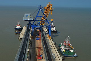
The Dhamra Port is a port in Bhadrak district, Odisha, India, on the shore of the Bay of Bengal about seven kilometers from the old port of Dhamra. The agreement to develop the port was signed in April 1998. The Dhamra Port Company Limited (DPCL) was formed as a result of a 50:50 joint venture between Larsen & Toubro and TATA Steel to run the port. The Port received its first vessel on 8 February 2010 and the first commercial vessel on 10 April 2011. The Port has an initial capacity of 25 million tonnes annually, eventually growing to 80 million tonnes annually. Greenpeace has opposed the project, claiming it threatens nearby protected areas and endangered species such as the olive ridley turtle
Gop is a town and a NAC under jurisdiction of Puri district in the Indian state of Odisha. It is one of the main block covered under Puri district. It is famous for the Sun temple, Kathiawar comprises square sanctum circumscribed by double courtyards. The important villages like Biratunga(Swami Nigamananda's Ashram of Nilachala Saraswata Sangha, Puri is located here), Begunia, Nimapara, Nagapur, Kakatpur, Bhaimapur, Ganeswarpur, Kusabhadra surround Gop.
Karilopatna (Karilo patna, Karilo patana, is a village near Patkura in Kendrapara district in the Indian state of Odisha.
Koraput is a Vidhan Sabha constituency of Koraput district, Odisha.

The 1971 Odisha cyclone was a devastating tropical cyclone that struck the Indian state of Odisha on October 29, 1971. The cyclone also affected another Indian state of West Bengal and East Pakistan, which has been devastated by 1970 Bhola cyclone just less than a year prior and was in the middle of Bangladesh Liberation War.
Sisua is a medium-sized village in the Salepur taluk/mandal/tehsil/block of Cuttack district in the state of Odisha, India, close to the new Sisua Village Jagannath Temple. The village lies South of Cuttack to Kendraparda road left of Sisua village road if traveling South. As of 2009 Kantapara is the gram panchayat of Sisua village
Sunadhar is a coastal village situated near the bank of the Devi River in the Jagatsinghpur district of Odisha, India. It is a part of the Gandakula region, which is divided into two villages, Bairakha and Sunadhar.
References
- ↑ "Directory of All Districts" (PDF). Odisha Government. Archived from the original (PDF) on 21 July 2011. Retrieved 14 November 2010.
- ↑ "Jagatsinghpur residents in Orissa observe Rath Yatra in festive fervor". Orissa Diary. 13 July 2010. Archived from the original on 27 September 2011. Retrieved 24 November 2010.
- ↑ G. K. Ghosh, Shukla Ghosh (1995). Indian textiles: past and present. APH Publishing. p. 161. ISBN 81-7024-706-3.
- ↑ P.P.MISHRA. "Urbanization in Medieval Orissa". International Institute for Asian Studies. Retrieved 24 November 2010.
- ↑ Gramin Vikas Sewa Sanstha. "Evaluation study of Rehabilitation & Reconstruction Process in Post Super Cyclone, Orissa" (PDF). Planning Commission, Government of India. Retrieved 24 November 2010.
- ↑ "Orissa coast awash with dead olive Ridley sea turtles". The Hindu. 27 January 2001. Retrieved 24 November 2010.
- ↑ "Ridleys back in death zone". Wildlife Society of Orissa. 22 January 2007. Archived from the original on 15 December 2010. Retrieved 24 November 2010.
Coordinates: 20°19′57″N86°15′02″E / 20.332390°N 86.250506°E
| This article about a location in Jagatsinghpur district, Odisha, India is a stub. You can help Wikipedia by expanding it. |