Cicero is a town in Cook County, Illinois, United States, and a suburb of Chicago. As of the 2020 census, the population was 85,268, making it the 11th-most populous municipality in Illinois. The town is named after Marcus Tullius Cicero, a Roman statesman and orator. With over 89% of the town being of Hispanic descent, the town is the most Hispanic in the state of Illinois.

Westchester is a village in Cook County, Illinois, United States. It is a western suburb of Chicago. The population was 16,892 at the 2020 census.
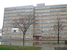
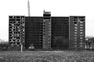
Cabrini–Green Homes are a Chicago Housing Authority (CHA) public housing project on the Near North Side of Chicago, Illinois. The Frances Cabrini Rowhouses and Extensions were south of Division Street, bordered by Larrabee Street to the west, Orleans Street to the east and Chicago Avenue to the south, with the William Green Homes to the northwest.
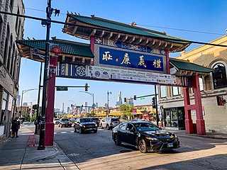
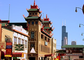
Chinatown is a neighborhood on the South Side of Chicago, along S. Wentworth Avenue between Cermak Road and W. 26th St. Over a third of Chicago's Chinese population resides in this ethnic enclave, making it one of the largest concentrations of Chinese-Americans in the United States. It formed around 1912, after settlers moved south from near the Loop, where the first enclaves were established in the 19th century.

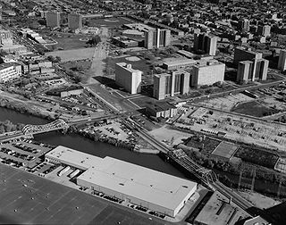
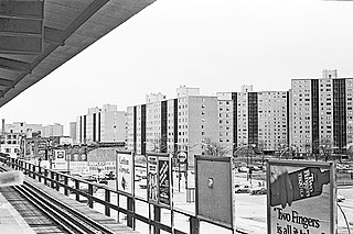
Robert Taylor Homes was a public housing project in the Bronzeville neighborhood on the South Side of Chicago, Illinois from 1962 to 2007. The second largest housing project in the United States, it consisted of 28 virtually identical high-rises, set out in a linear plan for two miles, with the high-rises regularly configured in a horseshoe shape of three in each block. It was located along State Street between Pershing Road and 54th Street, east of the Dan Ryan Expressway. The project was named for Robert Rochon Taylor (1899–1957), an African-American activist and the first African American chairman of the Chicago Housing Authority (CHA). It was a part of the State Street Corridor which included other CHA housing projects: Stateway Gardens, Dearborn Homes, Harold Ickes Homes, and Hilliard Homes.
Armour Square is a Chicago neighborhood on the city's South Side, as well as a larger, officially defined community area, which also includes Chinatown and the CHA Wentworth Gardens housing project. Armour Square is bordered by Bridgeport to the west, Pilsen to the northwest, Douglas and Grand Boulevard to the east and southeast, and with the Near South Side bordering the area to the north, and Fuller Park bordering its southernmost boundary, along Pershing Road.
Stateway Gardens was a Chicago Housing Authority (CHA) public housing project in the Bronzeville neighborhood on the South Side of Chicago, Illinois, alongside the Dan Ryan Expressway just north of the former Robert Taylor Homes, and part of the State Street Corridor that also included Dearborn Homes, Harold Ickes Homes and Hillard Homes. Stateway Gardens consisted of mid- and high-rise apartment buildings.

Cermak Road, also known as 22nd Street, is a 19-mile, major east–west street on Chicago's near south and west sides and the city's western suburbs. In Chicago's street numbering system, Cermak is 2200 south, or twenty-two blocks south of the baseline of Madison Street. Normally, one mile comprises eight Chicago blocks, but the arterial streets Roosevelt Road, formerly named Twelfth Street and at 1200 South, and Cermak Road were platted before the eight-blocks-per-mile plan was implemented. Roosevelt Road is one mile south of Madison Avenue and there are twelve blocks within that mile. Cermak Road is two miles south of Madison Avenue and there are ten blocks within the mile between Roosevelt and Cermak Roads.
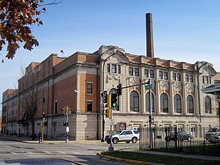
The Chicago Housing Authority (CHA) is a municipal corporation that oversees public housing within the city of Chicago. The agency's Board of Commissioners is appointed by the city's mayor, and has a budget independent from that of the city of Chicago. CHA is the largest rental landlord in Chicago, with more than 50,000 households. CHA owns over 21,000 apartments. It also oversees the administration of 37,000 Section 8 vouchers. The current acting CEO of the Chicago Housing Authority is Tracey Scott.
Rockwell Gardens was a Chicago Housing Authority (CHA) public housing project located in the East Garfield Park neighborhood on the Near West Side of Chicago, Illinois, United States. It was the first public housing development in the United States to be constructed using both federal and state funds. The original structures were designed by Nicol & Nicol and covered 17 acres (6.9 ha). 1,126 units of land. The second complex were located along Jackson Blvd and were standard Walk-up units in row like formations. This section is now a park as of 2014. The entire complex was located approximately 2.5 miles (4.0 km) west of the Chicago Loop, bordered by Madison Street, Van Buren Street, Western Avenue, and Rockwell Street.

Henry Horner Homes was a Chicago Housing Authority (CHA) public housing project located in the Near West Side community area on the West Side of Chicago, Illinois, United States. The original section of Henry Horner Homes was bordered by Oakley Boulevard to the west, Washington Boulevard to the south, Hermitage Avenue to the east, and Lake Street to the north near the United Center. A discontiguous section named Horner Annex was bordered by Honore Street to the west, Adams Street to the south, Wood Street to the east, and Monroe Street to the north. Constructed between 1957 and 1963, The housing project was named in honor of former Illinois governor Henry Horner.
The Fernwood Park Race Riot was a race massacre instigated by white residents against African American residents who inhabited the Chicago Housing Authority (CHA) veterans' housing project in the Fernwood Park neighborhood in Chicago. Area residents viewed this as one of several attempts by the CHA to initiate racial integration into white communities. The riot took place between 98th and 111th streets and lasted for three days, from the day veterans and their families moved into the project, August 13th, 1947 to August 16th, 1947. The Chicago Police Department did little to stop the rioting, as was the case a year before at the Airport Homes race riots. It was one of the worst race riots in Chicago history.

The Ida B. Wells Homes, which also comprised the Clarence Darrow Homes and Madden Park Homes, was a Chicago Housing Authority (CHA) public housing project located in the heart of the Bronzeville neighborhood on the South Side of Chicago, Illinois. It was bordered by 35th Street to the north, Pershing Road to the south, Cottage Grove Avenue to the east, and Martin Luther King Drive to the west. The Ida B. Wells Homes consisted of rowhouses, mid-rises, and high-rise apartment buildings, first constructed 1939 to 1941 to house African American tenants. They were closed and demolished beginning in 2002 and ending in 2011.

Dearborn Homes is a Chicago Housing Authority (CHA) public housing project located in the Bronzeville neighborhood on the South Side of Chicago, Illinois. It is located along State Street between 27th and 30th Streets, and bounded by the Metrarail line to the west. It is one of only two housing projects that still exist from the State Street Corridor which included other CHA developments: Robert Taylor Homes, Stateway Gardens, Harold Ickes Homes and Hillard Homes.

Julia C. Lathrop Homes is a Chicago Housing Authority (CHA) public housing project located along the line between the Lincoln Park and North Center neighborhoods on the north side of Chicago, Illinois, United States. It is bordered by the neighborhoods of Bucktown and Roscoe Village. Completed in 1938 by the Public Works Administration, Lathrop Homes was one of the first Chicago public housing projects. Lathrop Homes was placed on the National Register of Historic Places in 2012 and is currently undergoing restoration. Lathrop Homes consists of two-story brick row houses and three- and four-story apartment buildings separated by landscaped courtyards and linked by small archways in a campus-like arrangement. There are a total of 925 units on 35.5 acres of land.
Prairie Avenue Courts was a Chicago Housing Authority (CHA) public housing project in the South Commons neighborhood located on the south side of Chicago, Illinois, United States. First buildings completed in 1952, Prairie Avenue Courts consisted of two-story row-houses, seven and fourteen-story buildings. Prairie Avenue Courts were located to the south of McCormick Place and adjacent to Dunbar Park and Dunbar Vocational High School.

Marion Nzinga Stamps was an African-American community activist who fought for equal rights of public housing residents in the Cabrini-Green housing project on the Near-North Side of Chicago, Illinois. She helped to elect Chicago's first African-American mayor, Harold Washington, by organizing a massive voter registration drive in 1983. She was aggressive in her fights to make sure that residents of housing developments had voices regarding their violent and harsh living conditions in public housing. In 1993, Stamps began working with many gang leaders throughout Chicago to help end growing violence. In 1994 she and others successfully navigated what remains the only citywide gang truce in Chicago's history.

Hilliard Towers Apartments, formerly known as the Raymond Hilliard Homes CHA housing project, is a residential high-rise development in the near South Side of Chicago, Illinois. It was designed by Bertrand Goldberg and is bounded by Clark Street, State Street, Cullerton Street, and Cermak Road. In 1999, it was placed on the National Register of Historic Places as the Raymond M. Hilliard Center Historic District. The development was named for Raymond Marcellus Hilliard, who was the director of the Cook County Department of Welfare from 1954 until his death in 1966.

The Lake Michigan High-Rises, also known as Lakefront Homes, was a Chicago Housing Authority (CHA) public housing project in the North Kenwood–Oakland neighborhood located in the South Side of Chicago, Illinois, United States. Constructed in 1962 and completed in 1963, The Lake Michigan High-Rises originally consisted of four 16–story buildings; totaling 457 units. The Lake Michigan High-Rises was located west of Lake Shore Drive and was included as a part of the CHA Lakefront Properties. Today, only two buildings of the Lakefront Properties exist; they were officially renamed from Victor Olander Homes to Lake Parc Place in 1991. The other four high–rises were demolished by implosion in December 1998, it was the first and only to date in Chicago Housing Authority history.
The National Public Housing Museum is a historical institution that will be opening at 1322 W Taylor St. in Chicago, Illinois, and currently is located at 625 N Kingsbury St. in Chicago. The museum is located in the last remaining building of the Jane Addams Homes of ABLA Homes, and will feature an oral history archive, public programming, and an entrepreneurship hub. Exhibitions will include restored apartment of three families who lived in the Jane Addams homes. The building that the museum is contained within opened in 1938 as the first federal government housing project in Chicago. It housed thousands of families over six decades and has been vacant since 2002