Green Line (CTA)

Last updated
Green Line
Cottage Grove-bound train approaching Roosevelt station, December 2018.JPG
A Cottage Grove-bound Green Line train of 5000-series cars approaching the Roosevelt station.
Overview
StatusOperational
Locale Chicago, Oak Park and Forest Park, Illinois, United States
Termini
Stations30
Website CTA Green Line
Service
Type Rapid transit
System Chicago "L"
Operator(s) Chicago Transit Authority
Depot(s) Ashland Yard, Harlem Yard
Rolling stock 5000-series
6 car trains (typical); 8 car maximum
Daily ridership19,018 each weekday (2022)
History
OpenedFebruary 21, 1993;31 years ago (1993-02-21)
(Current operation)
Technical
Line length20.695 mi (33.305 km)
CharacterElevated
Track gauge 4 ft 8+12 in (1,435 mm) standard gauge
Minimum radius 90 feet (27 m)
Electrification Third rail,  600 V DC
Route map
Green Line (CTA) Green Line highlighted in green
BSicon DCONTg.svg
BSicon KBHFa green.svg
BSicon lGRZaq.svg
BSicon lINTACC.svg
BSicon HUBaq.svg
BSicon lDKBHFa.svg
BSicon lGRZeq.svg
BSicon lINTACC.svg
BSicon HUBeq.svg
BSicon DBHF.svg
Harlem/Lake | Metramlogo.svg Oak Park
BSicon DBHF green.svg
BSicon MFADEf.svg
BSicon DSTR.svg
Oak Park
BSicon DBHF green.svg
Ridgeland
BSicon GRZq.svg
BSicon GRZq.svg
BSicon DSTR green.svg
BSicon GRZq.svg
BSicon DBHF green.svg
Austin
BSicon lACC.svg
BSicon DBHF green.svg
Central
BSicon hACC green.svg
Laramie
BSicon hACC green.svg
Cicero
BSicon hACC green.svg
Pulaski
BSicon hACC green.svg
BSicon ehBHF green.svg
Homan
demolished
BSicon hACC green.svg
Kedzie
BSicon hACC green.svg
California
BSicon ehBHF green.svg
Damen
opening 2024
BSicon hCONTgq pink.svg
BSicon STR green.svg
BSicon tSTR+r pink.svg
BSicon hABZg+r pink.svg
BSicon tINTACC pink.svg
BSicon hBHF green.svg
Ashland
BSicon tACC pink.svg
BSicon hBHF green.svg
Morgan
BSicon tSTR pink.svg
BSicon ehBHF green.svg
Halsted
demolished
BSicon tINTACC pink.svg
BSicon hBHF green.svg
BSicon MFADEg.svg
BSicon hSTR.svg
Clinton
BSicon hKINTACCaq.svg
BSicon MSTR.svg
BSicon hSTR green.svg
BSicon tSTR pink.svg
BSicon hSTRq.svg
BSicon hSTRr.svg
BSicon WASSERq.svg
BSicon tSTR pink.svg
BSicon lhLFT.svg
BSicon hKRZW green.svg
BSicon WASSERq.svg
BSicon hCONTgq black.svg
BSicon KRZ+r orange.svg
BSicon KRZr pink.svg
BSicon KRZ+l black.svg
BSicon STR green.svg
BSicon tSTR pink.svg
BSicon lhKRZhr+lr.svg
BSicon hCONTfq black.svg
BSicon tCONTg blue.svg
BSicon tSTR black.svg
BSicon hSTR green.svg
BSicon tINTACC-L blue.svg
BSicon tINTACC-R black.svg
BSicon hBHF green.svg
Clark/Lake
BSicon tCONTgq blue.svg
BSicon tSTRr blue.svg
BSicon hSTR green.svg
BSicon tSTR black.svg
BSicon tSTRc2 red.svg
BSicon tCONTl+3 red.svg
BSicon HUBc2.svg
BSicon tSTRc2 red.svg
BSicon hBHF green.svg
BSicon tINT black.svg
BSicon HUB3.svg
BSicon tSTR3+1 red.svg
BSicon tSTRc4 red.svg
State/Lake
BSicon lINTACC.svg
BSicon HUB1.svg
BSicon tSTR+1 red.svg
BSicon tSTR black.svg
BSicon tSTRc4 red.svg
BSicon HUBc4.svg
BSicon hSTR green.svg
BSicon MFADEf.svg
BSicon tSTR red.svg
BSicon etBHF black.svg
BSicon hBHF green.svg
Randolph/Wabash
demolished 2017
BSicon tINTACC black.svg
BSicon hBHF green.svg
Washington/Wabash Metramlogo.svg BSicon South Shore Line.svg
BSicon etBHF black.svg
BSicon hBHF green.svg
Madison/Wabash
demolished 2015
BSicon tINT black.svg
BSicon hBHF green.svg
Adams/Wabash
BSicon hCONTgq black.svg
BSicon STRr black.svg
BSicon STR green.svg
BSicon tSTR orange.svg
BSicon tSTRr black.svg
BSicon hABZgr+r orange.svg
BSicon MFADEg.svg
BSicon tSTR red.svg
BSicon tSTR orange.svg
BSicon hSTR green.svg
BSicon tSTRc2 red.svg
BSicon lINTACC-L.svg
BSicon tSTR3 red.svg
BSicon tINTACC-R orange.svg
BSicon hBHF green.svg
Roosevelt
BSicon MFADEf.svg
BSicon tSTR+1 red.svg
BSicon tSTRc4 red.svg
BSicon tSTR orange.svg
BSicon hSTR green.svg
BSicon hCONTgq orange.svg
BSicon STRr orange.svg
BSicon STR green.svg
BSicon tSTRr orange.svg
BSicon lhABZgr.svg
BSicon hACC green.svg
35th–Bronzeville–IIT
BSicon hACC green.svg
Indiana
BSicon hACC green.svg
43rd
BSicon hACC green.svg
47th
BSicon hACC green.svg
51st
BSicon hACC green.svg
Garfield BSicon PARKING.svg
BSicon ehBHF green.svg
58th
demolished
BSicon hSTR+l green.svg
BSicon hABZlr green.svg
BSicon hSTR+r green.svg
BSicon hSTR green.svg
BSicon ehBHF green.svg
61st
demolished
BSicon hSTR green.svg
BSicon hACC green.svg
King Drive
BSicon hSTR green.svg
BSicon hKACCxe green.svg
Cottage Grove
BSicon hSTR green.svg
BSicon exKBHFe green.svg
BSicon lhKBHFe.svg
University
demolished
BSicon hCONTgq.svg
BSicon MSTR.svg
BSicon hSTR green.svg
BSicon hSTRq.svg
BSicon hCONTfq.svg
RI
BSicon STR red.svg
BSicon MFADEg.svg
BSicon vRP2.svg
BSicon hSTR green.svg
BSicon STRl red.svg
BSicon vRP2l.svg
BSicon STRq red.svg
BSicon lhMSTR.svg
BSicon STR green.svg
BSicon vRP2q.svg
BSicon CONTfq red.svg
BSicon vRP2w.svg
BSicon hCONTgq.svg
BSicon MSTR.svg
BSicon hSTR green.svg
BSicon hSTRq.svg
BSicon hCONTfq.svg
SWS
BSicon hACC green.svg
Halsted
BSicon ehBHF green.svg
Racine
closed 1994
BSicon hKACCe green.svg
Ashland/63rd BSicon PARKING.svg
BSicon GRZq.svg
Direct connection
outside of paid area
BSicon tSTRq orange.svg
BSicon hSTRq green.svg
Other line sharing
Green Line tracks
BSicon tSTRq black.svg
BSicon hSTRq green.svg
Multiple lines sharing
Green Line tracks
BSicon BUS2.svg
Bus connections available at all stations
except Morgan and Conservatory

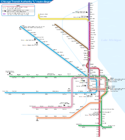
The Green Line is a rapid transit line in Chicago, Illinois, operated by the Chicago Transit Authority (CTA) as part of the Chicago "L" system. It is the only completely elevated route in the "L" system. All other routes may have various combinations of elevated, subway, street level (at grade), or freeway median sections. [1]

Contents

The Green Line utilizes the system's oldest segments, dating back to 1892. It extends for 20.695 miles (33.305 km), with 30 stops between Oak Park/Forest Park (Harlem/Lake) and Chicago's West Side, to the Loop, and then to the South Side neighborhoods of West Englewood (Ashland/63rd) and Woodlawn (Cottage Grove/63rd). As of 2022, 19,018 passengers board this line each weekday. [2]

Route

Harlem and Lake station.jpeg
Harlem/Lake Green Line entrance in Forest Park/Oak Park (2015)
Lakeriver.jpg
The Lake Street Elevated bridge over the Chicago River at night (2005)
CTA Night.jpg
Northward view from the Adams/Wabash station at night (2009)
McCormick Tribune 060304.jpg
A southbound train passes over the McCormick Tribune Campus Center at the Illinois Institute of Technology (2006)
Ashland63 CTA.jpg
The Englewood branch's Ashland/63rd station and terminal (2009)
Cottage Grove L Station (Chicago, USA).jpg
Cottage Grove station (2002)

Lake Street Elevated

Beginning at the yard and inspection facilities in Forest Park, the Green Line runs east through Oak Park towards the city on an embankment adjacent to Metra's Union Pacific West Line tracks from the Harlem Avenue terminal, on the border of Oak Park and Forest Park, to a point just west of Laramie Avenue. Here, the Green Line tracks diverge from the railroad embankment and continue east on a steel elevated structure directly above Lake Street, a major east–west thoroughfare.

The "L" bridges a couple of railroad tracks (the Belt Railway of Chicago's main line and Union Pacific's Rockwell Subdivision) before entering downtown Chicago at Clinton Street. East of Clinton Street, the route bridges Metra's Union Pacific railroad tracks (which terminate just south of here at Ogilvie Transportation Center) and the Chicago River before joining the Union Loop "L" tracks at Wells Street.

The Loop

In downtown Chicago, the Green Line operates over the famous Union Loop "L" structure along with Brown Line (Ravenswood), Orange Line (Midway), Pink Line (Douglas) and Purple Line Express (weekday rush hours only) trains. However, Green Line trains operate both ways over the Lake Street and Wabash Avenue sides only, and does not use the Wells Street and Van Buren Street sides of the Loop.

The Green Line is the only line in the "L" system that has two entry/exit points to the elevated Loop, the only "L" line that runs in both directions on the Loop, and the only route that uses the Loop but does not terminate there. Its route uses the Wabash and Lake sides of the Loop, which are also used by the Orange, Pink, Purple and Brown Lines, which operate around the Loop and then return to their route terminal.

South Side Elevated

Leaving the Loop at Tower 12, the tracks continue along Wabash Avenue and follows an "S" curve (which was realigned in 2002) to the west and south now following the alley between Wabash Avenue and State Street to 40th Street. This 3.8 mile section is the oldest part of Chicago's "L" system. On this segment, the Green Line shares tracks with the Orange Line between the Loop and 17th Street. Passengers can transfer between the two lines at Roosevelt/Wabash station.

The other stations on this section are at Cermak–McCormick Place and 35thBronzevilleIIT, adjacent the Illinois Institute of Technology campus and the Chicago Police Department Headquarters. At 40th Street, the route turns east to Indiana station, then turns south between Calumet and Prairie Avenues to the Garfield station and continues south to 59th Street where the route splits into two branches—the Englewood (Ashland/63rd) branch and the Jackson Park (East 63rd) branch. Prior to 1994 (and the Green Line's major renovation) the East 63rd branch extended as far east as Stony Island Avenue. It was shortened to University in 1982 and Cottage Grove in 1996.

Ashland branch

The Ashland branch continues south and west following 59th Street, Princeton Avenue and 63rd Street to the Ashland terminal in West Englewood. The yard and inspection shop lie to the south between the old Racine station and the Ashland/63rd terminal. The "L" tracks continues west to a stub end at Hermitage Avenue, a prediction for a future extension of the route westward, however, those plans were canceled in the late 1970s. Prior to 1992, the Englewood branch had two additional stops at Wentworth and Harvard, closed by the CTA for service cuts. Halsted/63rd is the only remaining stop on the 3.1 miles (5.0 km) route.

The Englewood branch was permanently renamed the Ashland branch as of March 2013 according to the CTA.

Jackson Park branch

The Jackson Park branch continues south from the mainline between Calumet and Prairie Avenues, passing the old yard and inspection facilities at 61st Street in Washington Park. South of here, the route curves east over 63rd Street and follows it to the current terminal at Cottage Grove/63rd in Woodlawn. Prior to 1994, the Jackson Park branch of the Green Line once terminated at University/63rd and before that, at Stony Island/63rd from 1893 until 1982. In addition to losing the University/63rd station, the Jackson Park branch also lost the 61st Street station and the 58th Street station in 1994.

Operating hours and headways

The Green Line operates weekdays from 4 a.m. to 1 a.m., and Saturdays and Sundays from 5 a.m. to 1 a.m. Between Harlem/Lake and Garfield, trains run on a minimum headway of 12 minutes, decreasing to as few as 10 minutes during weekday rush hours. Headways are doubled on the branches to Ashland/63rd and Cottage Grove. [3]

Rolling stock

The Green Line is operated with the Bombardier-built 5000-series railcars. The 5000-series cars officially began running on the Green Line on July 1, 2012, after the Pink Line became fully equipped with the new cars. As additional 5000-series cars were assigned to the Green Line, the remaining 2400-series cars were reassigned to the Red, Purple and Orange Lines to finish their service lives. Occasionally, 2600-series and 3200-series railcars were used on the Green Line, though these were loaned from the Blue, Brown, and Orange Lines, and only when the Green Line was short on cars.

With the 5000-series cars now completely equipping the Green Line fleet after the last of the 2400-series cars were reassigned in mid-May 2013, the borrowing of 2600-series cars and 3200-series cars is no longer necessary. The Green Line was the second line to be fully equipped with the 5000-series cars, following the Pink Line. Frequently, the Green and Pink Lines borrow each other's cars when either line is short on cars. Trains operate using six cars full time as of 2020.

History

Chicago Transit Authority signal tower 18 guides Chicago "L" trains, north and southbound Purple and Brown lines intersecting with east and westbound Pink and Green lines and the Orange line above the Wells and Lake street intersection in the loop. CTA loop junction.jpg
Chicago Transit Authority signal tower 18 guides Chicago "L" trains, north and southbound Purple and Brown lines intersecting with east and westbound Pink and Green lines and the Orange line above the Wells and Lake street intersection in the loop.

The Green Line operates over the two oldest sections of the Chicago "L". The South Side section started operation in 1892 when Chicago was preparing for the World's Columbian Exposition of 1893 in Jackson Park. The initial section was built to provide inexpensive mass transportation service between downtown Chicago and the exposition site. This first section of the Chicago and South Side Rapid Transit Railroad between Wabash Avenue and State Street went into service on June 6, 1892. [4] It extended from Congress Street only as far south as 39th Street (Pershing Road). At that time a large part of the south side was little more than prairie, but by May 1, 1893, when the pioneer "L" line was completed to Jackson Park, construction of homes, apartment buildings and commercial properties was booming in the area.

Continued expansion of the area development was reflected in construction of the Englewood, Normal Park, Kenwood and Stock Yards branches of the South Side "L" between 1905 and 1908. Of these, only the Englewood and Jackson Park branches remain: because of insufficient patronage, the Normal Park, Stock Yards and Kenwood branches were closed in the 1950s.

View from Ashland station along the Lake Street section of the Green Line (2005) CTA Ashland 050716.jpg
View from Ashland station along the Lake Street section of the Green Line (2005)
Pink and Green line elevated tracks crossing Franklin Street in the Loop (2005) Chicago 2005 marathon.jpg
Pink and Green line elevated tracks crossing Franklin Street in the Loop (2005)
Chicago Transit Authority Chicago "L" route map Chicago L diagram sb.svg
Chicago Transit Authority Chicago "L" route map

The Lake Street Elevated was Chicago's second rapid transit line. It began operation from a terminal at Madison and Market streets to Lake Street and California Avenue on November 6, 1893. [5] The line was gradually extended westward to Laramie Avenue on April 29, 1894; to Austin Avenue on April 15, 1899; [6] to Wisconsin Avenue, Oak Park using street railway trackage on May 15, 1899 (closed in 1902), and to Marengo Avenue, Forest Park, on May 14, 1910.

The construction of the Lake Street Elevated led to a political quarrel in west suburban Cicero, which at the time included Oak Park and Austin. In 1898, Austinites, having a majority on Cicero's town council, used political influence to allow the extension of the Lake Street line from the city border at Laramie Avenue (then called 52nd Avenue) into their community. This infuriated other Cicero residents, who retaliated the following year by holding a joint election to force Austin's annexation to the City of Chicago. Much to the dismay of local residents, this effort succeeded, and Austin became part of Chicago in 1899. A century later, Oak Park commuters, who had come to depend on the service, were among the most vocal critics of the Green Line's closure for rehabilitation.

From 1913 until 1993, the Englewood and Jackson Park branches were part of the North–South Route in various service configurations operating from the north side through the Loop and to the south side. On October 17, 1943, the Englewood and Jackson Park services were rerouted into the State Street subway to provide improved crosstown access through the heart of city and to alleviate congestion on the over-crowded Union Loop Elevated. On July 31, 1949, during the north–south rapid transit service revision by the CTA, the Howard–Englewood/Jackson Park route was created, operating via the State Street subway, using the 13th Street portal.

On May 6, 1969, the Englewood branch was extended to the current Ashland Avenue-West Englewood Terminal, replacing the outmoded facilities at the 1907-built Loomis station which were demolished. On December 12, 1982, the Jackson Park branch was shortened to University because of structural deterioration at the Dorchester Bridge which carried the route across the Illinois Central Railroad to the former Stony Island/63rd terminal which closed on March 4, 1982, and was later demolished.

The Lake Street "L" would remain largely unchanged until 1948, when a number of its historic passenger stations were closed and demolished in an attempt to promote the "A" and "B" skip-stop express train service to speed up traffic flow. On October 28, 1962, the western two and one-half mile section of the line which operated at street level was elevated along the Chicago and Northwestern Railroad right-of-way opening new elevated stops at Central, Austin, Ridgeland, Oak Park, and Harlem.

In September 1969, the Lake Street "L" was united with the new Dan Ryan Line to form the West–South Route (Lake-Dan Ryan), operating from Forest Park through downtown via the Union Loop "L" to 95th/Dan Ryan. The Lake–Dan Ryan routing was to fulfill the service implementation outlined in the 1968 Chicago Central Area Transit Plan. However, when that subway project was canceled in 1979, Lake–Dan Ryan service remained and lasted for 24 years.

In February 1993, the South Side sections of the North–South and West–South Routes were "switched" south of Roosevelt Road, creating the current Red Line (Howard–Dan Ryan) and the Green Line (Lake–Englewood/Jackson Park). After the reconfiguration, both the Red and Green Lines lost their "A" and "B" skip-stop service and began serving all stations at all times. As stated earlier, the Green Line's routing united the two oldest segments of Chicago's "L"-Subway rail network.

In January 1994, the Green Line closed for the largest transit rehabilitation project in the city's history. The Green Line reopened on May 12, 1996, with much of the renewal work completed and with the exception of a few stations. Six stations (Homan, Halsted, 58th, 61st, University, and Racine) were closed permanently following the rehabilitation project, which angered many commuters who depend on the Green Line.

In September 1997, after political pressure brought on by community leaders, the Jackson Park branch was shortened again from University to Cottage Grove after previous attempts by the city, CTA, and other agencies to extend the route eastward to Dorchester, immediately west of the Illinois Central Railroad. This had seemed logical to the Dorchester Terminal, due to the fact that the Metra Electric District and South Shore Line both share a station along the IC ROW, at 63rd Street.

In April 1998, the Green Line, like the Purple Line and the Douglas branch of the Blue Line (now the Pink Line) lost its 24-hour service due to budget cuts, and operates only between the hours of 4 a.m. and 1 a.m weekdays.

Incidents

On February 4, 1977, an accident occurred on the sharp left-hand curve at Wabash/Lake. Two trains were involved, one was the Ravenswood Line with the second being the Lake-Dan Ryan Line. The Ravenswood train was stopped waiting for the clearance to proceed. The motorman of the Lake-Dan Ryan train failed to see the signals warning him of a stopped train. What occurred was a rear-end collision, the initial collision was only minor. However the motorman continued to apply power forward; which led to three cars being pushed off the elevated tracks to the street below. The fourth car was dangling while still attached to the other four cars on the track. Eleven deaths were reported with more than 180 injuries. [7]

On May 28, 2008, a derailment was reported, with approximately 24 injuries. Two train cars on the four-car train appeared to be derailed, with the leading car abutting the one behind it at an angle of approximately 150 degrees. The train cars were separated at a switching point near 59th Street. [8]

On August 5, 2015, a derailment was reported near 63rd and Calumet in Chicago's Washington Park neighborhood. The train derailed around 2:40 p.m., the third of the four-car train was the one to derail. No one was injured, firefighters had to help over 80 passengers off the train; two of which were in wheelchairs. Service was suspended between the Cottage Grove and Garfield stops. Service was back to normal in the affected stops around 7:15 p.m. [9]

On June 6, 2019, a Green Line train derailed near the 47th station, injuring seven people. [10] [11]

Green Line expansion

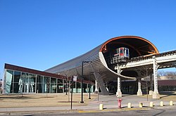
During the 2010s, the Green Line has undergone significant expansion in an attempt to attract more transit riders and improve upon its service connectivity on the West Side, Loop, and South Side communities. The Morgan/Lake station opened in May 2012 in response to the growing Fulton Market and West Loop areas. It was followed by the opening of the new Cermak–McCormick Place station in February 2015, serving the historic Motor Row District and McCormick Place Convention Center. Both stations were designed by Chicago-based Ross Barney Architects.

The Garfield station's $43 million reconstruction project, completed in January 2019, restored its original 1892-built station house and improved the in-service station house. It included escalator and elevator enhancements and new platform canopies, lights, graphics, public artwork, and streetscape. The project created a new "Garfield Gateway" station in the Washington Park neighborhood on the South Side.

A new station is being constructed on the Lake Street "L" at Damen/Lake, replacing a former station at that site from 1893 to 1948. Designed by world-renowned architectural firm Perkins + Will, who also designed the Cumberland station on the O'Hare Extension in 1980, the new $60 million Damen station will fill the 1.5-mile distance between the California and Ashland stations.

Along the Green Line South, the former 58th Street station, which was located approximately 3/8 mile south of the Garfield station and one-block north of the Englewood and Jackson Park branches, had been bereft of a transfer facility between the diverging Green Line services since 1994. The branch lines themselves consists of only two stations (Halsted and Ashland/63rd on the Englewood branch; King Drive and Cottage Grove on the Jackson Park Branch).

While no official plans have been developed to build future stations on the Green Line South, the possibility of a new Stony Island/63rd terminal station to serve Hyde Park, South Shore, the Museum of Science and Industry, and the proposed Barack Obama Presidential Center would be very advantageous. A major benefit would be the resurgence of passenger and traffic volumes on the Englewood and Jackson Park branches to those prior to 1982, with more modern, attractive, and convenient transit service on the South Side "L", thus supplementing, and not competing with the Dan Ryan branch of the Red Line.

Points of interest

The Green Line provides access to other destinations, the Garfield Park Conservatory (Conservatory–Central Park Drive), United Center (Ashland) James R. Thompson Center, Richard J. Daley Center and City Hall–Cook County Building (Clark/Lake), Millennium Park (Washington/Wabash), the Art Institute of Chicago (Adams/Wabash), the Auditorium Building of Roosevelt University, Museum Campus and Soldier Field (Roosevelt/Wabash), the Illinois Institute of Technology and Guaranteed Rate Field (White Sox Park) (35thBronzevilleIIT), the University of Chicago (Garfield) and Kennedy–King College (Halsted/63rd). The Clinton/Lake and Washington/Wabash stops are useful for reaching Metra and South Shore Line trains at the Ogilvie Transportation Center and Millennium Station.

Station listing

LocationStationPoints of interest and notes
Oak Park /
Forest Park
Harlem/Lake Wheelchair symbol.svg Points of interest:
Downtown Oak Park, Forest Preserve District of Cook County Headquarters
Connections:
Metramlogo.svg Metra trains:   Union Pacific West (at Oak Park)
Bus-logo.svg CTA buses: 90 Harlem
Bus-logo.svg Pace buses: 307 Harlem, 309 Lake Street, 313 St. Charles Road, 318 West North Avenue
Oak Park Oak Park Points of interest:
Frank Lloyd Wright Home and Studio, Unity Temple, Ernest Hemingway Museum & Birthplace, Oak Park Public Library
Connections:
Bus-logo.svg Pace buses: 309 Lake Street, 311 Oak Park Avenue, 313 St. Charles Road
Ridgeland Points of interest:
Oak Park and River Forest High School
Connections:
Bus-logo.svg CTA buses: 86 Narragansett/Ridgeland
Bus-logo.svg Pace buses: 309 Lake Street, 313 St. Charles Road, and 314 Ridgeland
Austin, Chicago Austin Connections:
Bus-logo.svg CTA buses: 91 Austin
Bus-logo.svg Pace buses: 309 Lake Street, 313 St. Charles Road, 315 Austin Boulevard
Central Wheelchair symbol.svg Points of interest:
Columbus Park, Walser House, Austin Town Hall
Connections:
Bus-logo.svg CTA buses: 85 Central
Laramie Wheelchair symbol.svg Connections:
Bus-logo.svg CTA buses: 57 Laramie
Cicero Wheelchair symbol.svg Connections:
Bus-logo.svg CTA buses: 54 Cicero
Bus-logo.svg Pace buses: 392 Green Line Cicero CTA/UPS Hodgkins
West Garfield Park Pulaski Wheelchair symbol.svg Connections:
Bus-logo.svg CTA buses: 53 Pulaski
East Garfield Park Conservatory–Central Park Drive Wheelchair symbol.svg Points of interest:
Garfield Park Conservatory, Garfield Park Field house
Homan Closed January 9, 1994; structure reused for Conservatory–Central Park Drive
Kedzie Wheelchair symbol.svg Connections:
Metramlogo.svg Metra trains:   Union Pacific West (at Kedzie)
Bus-logo.svg CTA buses: 52 Kedzie
California Wheelchair symbol.svg Points of interest:
Chicago Center for Green Technology
Connections:
Bus-logo.svg CTA buses: 94 California
Near West Side Damen Wheelchair symbol.svg Reopening 2024
Ashland Wheelchair symbol.svg Points of interest:
United Center, Union Park
Connections:
BSicon SUBWAY.svg CTA 'L' trains: Pink
Bus-logo.svg CTA buses: 9 Ashland, X9 Ashland Express
Morgan Wheelchair symbol.svg Points of interest:
UIC, Greektown, Coyne College, Fulton Market District
Halsted Closed January 9, 1994
Clinton Wheelchair symbol.svg Points of interest:
Chicago Transit Authority Headquarters
Connections:
BSicon SUBWAY.svg CTA 'L' trains: Pink
Metramlogo.svg Metra trains:   Union Pacific North,   Union Pacific Northwest,   Union Pacific West (at Ogilvie)
Bus-logo.svg CTA buses: J14 Jeffery Jump, 56 Milwaukee, 125 Water Tower Express
The Loop Clark/Lake Wheelchair symbol.svg Points of interest:
James R. Thompson Center, Richard J. Daley Center
Connections:
BSicon SUBWAY.svg CTA 'L' trains: Orange Blue Pink Purple Brown
Bus-logo.svg CTA buses: 22 Clark, 24 Wentworth, 134 Stockton/LaSalle Express, 135 Clarendon/LaSalle Express, 136 Sheridan/LaSalle Express, 156 LaSalle
State/Lake Points of interest:
Chicago Theatre, Gene Siskel Film Center, Harold Washington College
Connections:
BSicon SUBWAY.svg CTA 'L' trains: Red (at Lake)
Bus-logo.svg CTA buses: 2 Hyde Park Express, 6 Jackson Park Express, 10 Museum of Science & Industry, 29 State, 36 Broadway, 62 Archer, 146 Inner Lake Shore/Michigan Express
Randolph/Wabash Closed September 3, 2017; demolished and replaced by Washington/Wabash
Washington/Wabash Wheelchair symbol.svg Points of interest:
Chicago Cultural Center, Millennium Park
Connections:
Metramlogo.svg Metra trains:   Metra Electric (at Millennium Station)
BSicon South Shore Line.svg South Shore Line (at Millennium Station)
Bus-logo.svg CTA buses: J14 Jeffery Jump, 20 Madison, 56 Milwaukee, 60 Blue Island/26th, 124 Navy Pier, 147 Outer DuSable Lake Shore Express, 151 Sheridan, 157 Streeterville/Taylor
Madison/Wabash Closed March 16, 2015; demolished and replaced by Washington/Wabash
Adams/Wabash Points of interest:
Grant Park, Petrillo Music Shell, Buckingham Fountain, Art Institute of Chicago, Orchestra Hall, DePaul University
Connections:
BSicon SUBWAY.svg CTA 'L' trains: Orange Pink Purple Brown
Bus-logo.svg CTA buses: 1 Bronzeville/Union Station, 7 Harrison, 28 Stony Island, 126 Jackson, 151 Sheridan
Near South Side Roosevelt Wheelchair symbol.svg Points of interest:
Field Museum of Natural History, Soldier Field, Shedd Aquarium, Adler Planetarium
Connections:
BSicon SUBWAY.svg CTA 'L' trains: Red Orange
Metramlogo.svg Metra trains:   Metra Electric (at Museum Campus/11th Street)
BSicon South Shore Line.svg South Shore Line (at Museum Campus/11th Street)
Bus-logo.svg CTA buses: 12 Roosevelt, 18 16th/18th, 29 State, 62 Archer, 130 Museum Campus, 146 Inner Lake Shore/Michigan Express, 192 University of Chicago Hospitals Express
Near South Side Cermak–McCormick Place Wheelchair symbol.svg Points of interest:
McCormick Place, Wintrust Arena, Motor Row District
Connections:
Bus-logo.svg CTA buses: 21 Cermak
Douglas 35th–Bronzeville–IIT Wheelchair symbol.svg Points of interest:
Illinois Tech, Shimer College, De La Salle Institute, Stephen A. Douglas Tomb, Pilgrim Baptist Church, Victory Monument, Guaranteed Rate Field, Black Metropolis–Bronzeville District
Connections:
Metramlogo.svg Metra trains:   Rock Island (at 35th Street)
Bus-logo.svg CTA buses: 29 State, 31 31st, 35 31st/35th
Grand Boulevard Indiana Wheelchair symbol.svg Points of interest:
Wendell Phillips Academy High School, South Side Community Art Center
Connections:
Bus-logo.svg CTA buses: 39 Pershing
43rd Wheelchair symbol.svg Points of interest:
North Kenwood District, King College Prep High School
Connections:
Bus-logo.svg CTA buses: 43 43rd
47th Wheelchair symbol.svg Points of interest:
Harold Washington Cultural Center, Robert S. Abbott House
Connections:
Bus-logo.svg CTA buses: 47 47th
Grand Boulevard /
Washington Park
51st Wheelchair symbol.svg Points of interest:
Provident Hospital of Cook County, KAM Isaiah Israel, Kenwood Academy, Barack Obama House
Connections:
Bus-logo.svg CTA buses: 15 Jeffery Local
Washington Park Garfield Wheelchair symbol.svg BSicon PARKING.svg Transfer between Ashland/63rd and Cottage Grove-bound trains
58th Closed January 9, 1994
Englewood branch
Englewood Halsted Wheelchair symbol.svg Points of interest:
Kennedy-King College
Connections:
Bus-logo.svg CTA buses: 8 Halsted, 63 63rd
Englewood Racine Closed January 9, 1994
West Englewood Ashland/63rd Wheelchair symbol.svg BSicon PARKING.svg Connections:
Bus-logo.svg CTA buses: 9 Ashland, 63 63rd
Jackson Park branch
Washington Park 61st Closed January 9, 1994
Woodlawn King Drive Wheelchair symbol.svg Inbound boarding only
Connections:
Bus-logo.svg CTA buses: 3 King Drive, N4 Cottage Grove, 63 63rd
Woodlawn Cottage Grove Wheelchair symbol.svg Points of interest:
University of Chicago, University of Chicago Medical Center, Jackson Park, Oak Woods Cemetery
Connections:
Bus-logo.svg CTA buses: 4 Cottage Grove, X4 Cottage Grove Express, 63 63rd
University Closed January 9, 1994

Related Research Articles

<span class="mw-page-title-main">Chicago "L"</span> Rapid transit system in Chicago, Illinois, US

The Chicago "L" is the rapid transit system serving the city of Chicago and some of its surrounding suburbs in the U.S. state of Illinois. Operated by the Chicago Transit Authority (CTA), it is the fourth-largest rapid transit system in the United States in terms of total route length, at 102.8 miles (165.4 km) long as of 2014, and the second-busiest rapid transit system in the United States, after the New York City Subway. In 2016, the "L" had 1,492 rail cars, eight different routes, and 145 train stations. In 2023, the system had 117,447,000 rides, or about 373,800 per weekday in the fourth quarter of 2023.

<span class="mw-page-title-main">Red Line (CTA)</span> Rapid transit line in Chicago

The Red Line is a rapid transit line in Chicago, run by the Chicago Transit Authority (CTA) as part of the Chicago "L" system. It is the busiest line on the "L" system, with an average of 93,457 passengers boarding each weekday in 2022. The route is 26 miles (42 km) long with a total of 33 stations. It runs elevated from the Howard station in the Rogers Park neighborhood on the North Side, through a subway on the Near North Side, Downtown, and the South Loop, and then through the Dan Ryan Expressway median to 95th/Dan Ryan in the Roseland neighborhood on the South Side.

<span class="mw-page-title-main">Orange Line (CTA)</span> Rapid transit line in Chicago, Illinois

The Orange Line is a rapid transit line in Chicago, Illinois, operated by the Chicago Transit Authority (CTA) as part of the Chicago "L" system. It is approximately 13 miles (21 km) long and runs on elevated and at grade tracks and serves the Southwest Side, running from the Loop to Midway International Airport. As of 2022, an average of 15,098 riders board Orange Line trains on weekdays.

<span class="mw-page-title-main">Blue Line (CTA)</span> West-Northwest section of Chicago Rail System (L)

The Blue Line is a 26.93-mile-long (43.34 km) Chicago "L" line which extends through The Loop from O'Hare International Airport at the far northwest end of the city, through downtown via the Milwaukee–Dearborn subway and across the West Side to its southwest end at Forest Park, with a total of 33 stations. At about 27 miles, it is the longest line on the Chicago "L" system and second busiest, and one of the longest local subway/elevated lines in the world. It has an average of 64,978 passengers boarding each weekday in 2022.

The Chicago Central Area Transit Plan, generally referred to as the Chicago Central Area Transit Project (CCATP) in the 1970s, was an extensive study of the rapid transit system in downtown Chicago; the study had begun in 1965.

<span class="mw-page-title-main">Pink Line (CTA)</span> Rapid transit line in Chicago, Illinois

The Pink Line is an 11.2 mi (18.0 km) rapid transit line in Chicago, run by the Chicago Transit Authority (CTA) as part of the Chicago "L" system. It is the CTA's newest rail line and began operation for a 180-day trial period on June 25, 2006, running between 54th/Cermak station in Cicero, Illinois and the Loop in downtown Chicago. As the line enters downtown Chicago, it begins to share tracks with Green Line trains on Lake Street. This connection is handled by the previously non-revenue Paulina Connector set of tracks. In 2022, over 3 million passengers boarded Pink Line trains.

<span class="mw-page-title-main">Garfield station (CTA Green Line)</span> Chicago "L" station

Garfield is an "L" station on the CTA's Green Line. It is situated at 320 E. Garfield Boulevard in the Washington Park neighborhood. It opened on October 12, 1892. This station is the southernmost Green Line station served by both of the Green Line's branches: south of Garfield, the Green Line splits into two branches, one terminating at Ashland/63rd, and one at Cottage Grove.

<span class="mw-page-title-main">Ashland/63rd station</span> Chicago "L" station

Ashland/63rd is an 'L' station and the terminal of the CTA Green Line's Ashland branch, located in the West Englewood neighborhood of Chicago, Illinois. Situating at 6315 S. Ashland Avenue, the station contains a Park 'n' ride lot with 235 spaces as well as a Kiss 'n' Ride lane. This is one of two stations on the Green Line to be named Ashland. The other station is on the Lake Street branch and is shared between the Green and Pink Lines. The Red Line served this station from May 19, 2013 to October 20, 2013, April 3, 2017 to November 22, 2017, and July 30, 2018 to April 26, 2019.

<span class="mw-page-title-main">Cottage Grove station</span> Chicago "L" station

Cottage Grove, is an 'L' station and the terminus of the CTA Green Line's East 63rd branch, located in the Woodlawn neighborhood. The station is situated at 800 East 63rd Street and opened on April 23, 1893.

<span class="mw-page-title-main">Ashland station (CTA Green and Pink Lines)</span> Chicago "L" station

Ashland is an 'L' station on the CTA's Green and Pink Lines. It is an elevated station with two side platforms, located in Chicago's Near West Side neighborhood at 1601 West Lake Street. Just to the west of the station, the Pink Line branches off from the Lake Street branch to follow the Paulina Connector to the Douglas branch. The adjacent stations are California (Green), which is located about 1+12 miles (2.4 km) to the west, Polk (Pink), which is located about 1 mile (1.6 km) to the south, and Morgan station, approximately 34 mile (1.2 km) to the east.

<span class="mw-page-title-main">Austin station (CTA Green Line)</span> Chicago "L" station

Austin is a station on the Chicago Transit Authority's 'L' system. It is located between the Ridgeland and Central stations on the Green Line, which runs from Harlem/Lake and to Ashland/63rd and Cottage Grove. The station is located at the intersection of Austin Boulevard and Corcoran Place in the Austin neighborhood on Chicago's West Side and borders the village of Oak Park.

<span class="mw-page-title-main">South Side Elevated Railroad</span>

The South Side Elevated Railroad was the first elevated rapid transit line in Chicago, Illinois. The line ran from downtown Chicago to Jackson Park, with branches to Englewood, Normal Park, Kenwood, and the Union Stock Yards. The first 3.6 miles (5.8 km) of the line opened on June 6, 1892. Much of its route is still used today as part of the Green Line of the Chicago "L" system.

<span class="mw-page-title-main">Dan Ryan branch</span>

The Dan Ryan branch is a 9.4 mi (15.1 km) long section of the Chicago "L" system located on the South Side of Chicago, Illinois. It is operated by the Chicago Transit Authority, as part of its Red Line service and is normally through-routed downtown towards the North Side via the State Street subway. As of February 2013, the branch serves 45,355 passengers per weekday. As part of the CTA's busiest rapid transit line, it is operated 24 hours a day, 365 days a year. The branch serves the Chinatown, Armour Square, Fuller Park, Englewood, Greater Grand Crossing, Chatham and Roseland neighborhoods.

The Lake–Dan Ryan Line was a rail rapid transit route formerly operated by the Chicago Transit Authority (CTA). The Lake–Dan Ryan Line existed from the opening of the Dan Ryan branch on September 28, 1969, until February 21, 1993. When created, the route united two transit corridors that until 1969 never had through rail service. This routing, which became known as the West-South route, operated from the Harlem terminal in Forest Park on the Lake Street "L" through downtown Chicago along the Union Loop "L", and then via the old South Side "L" and the new Dan Ryan Line to the 95th Street Terminal. The Lake–Dan Ryan service was planned in conjunction with the former Franklin Street Connector and Chicago Central Area Transit Project, both of which were never constructed. The section of the route between the junction with the South Side "L" at 17th and State Streets and the Cermak–Chinatown Station was originally an "interim", or temporary facility. It was planned to be torn down when the Loop Subway system was completed, but survived after the project was canceled in 1979. That section was improved in the 1980s and early 1990s and is currently being used by the Orange Line. Train transfers are possible by using the two unused tracks.

<span class="mw-page-title-main">South Side Elevated</span> Elevated railway in Chicago

The South Side Elevated is a branch of the Chicago "L" system in Chicago, Illinois that is served by the Green Line. It has on average 12,509 passengers, counting branch divisions, boarding each weekday as of February 2013, according to the Chicago Transit Authority. The branch is 6.5 miles (10.5 km) long with a total of 8 stations, and runs from the Near South Side to the Washington Park neighborhood of Chicago.

<span class="mw-page-title-main">Roosevelt station (CTA)</span> Chicago "L" station

Roosevelt is an "L" station on the CTA's Red, Green, and Orange Lines, located between the Chicago Loop and the Near South Side in Chicago, Illinois. It is situated at 1167 S State Street, just north of Roosevelt Road. The station is also the closest "L" station to the Museum Campus of Chicago and Soldier Field, which are about 12 mile (800 m) to the east. The Museum Campus/11th Street Metra station is also about 13 mile (500 m) to the east.

<span class="mw-page-title-main">Lake Street Elevated</span> Rapid transit line in Chicago

The Lake Street Elevated, also known as the Lake branch, is a 8.75 mi (14.08 km) long branch of the Chicago "L" which is located west of the Chicago Loop and serves the Green Line for its entire length, as well as the Pink Line east of Ashland Avenue. As of February 2013, the branch serves an average of 27,217 passengers each weekday. It serves the Near West Side, East Garfield Park, West Garfield Park, and Austin neighborhoods of Chicago, as well as the suburbs Oak Park and Forest Park. It owes its name to Lake Street, the street that the branch overlooks for 6.25 mi (10.06 km) before continuing its route straight west, adjacent to South Boulevard, towards the terminus at Harlem/Lake.

<span class="mw-page-title-main">Loomis Street</span> Street in Chicago

Loomis Street is a north–south street in Chicago that is 1400 W in Chicago's grid system, making it 1.75 miles (2.82 km) west of the north–south baseline of State Street. It runs from the Chicago and Northwestern Railway tracks south, with interruptions, to Center Avenue in the suburb of Homewood. Between the railway tracks and the north branch of the Chicago River it is known as Noble Street and north of the River's north branch it is known as Southport Avenue. As Southport Avenue it goes up north to its intersection with Clark Street just south of Berteau. The street continues again at Argyle Street until Touhy Avenue as Glenwood Avenue.

References

  1. World.nycsubway.org – Chicago Green Line
  2. "Annual Ridership Report - Calendar Year 2019" (PDF). Chicago Transit Authority . 2020-01-16. pp. 17–19. Retrieved 2021-04-04.
  3. "Green Line Trains schedule" (PDF). Chicago Transit Authority. transitchicago.com. Retrieved 20 June 2023.
  4. "Running on the "L."". Chicago Daily Tribune. June 7, 1892. p. 9.
  5. "Crowds on Lake Street "L."". Chicago Daily Tribune. November 7, 1893. p. 8.
  6. "Austin Hails Five-Cent Fares". Chicago Daily Tribune. April 15, 1899. p. 5.
  7. Krambles, George; Peterson, Arthur H. (1993). CTA at 45. Oak Park, IL, U.S.A: Published for the George Krambles Transit Scholarship Foundation. p. 116. ISBN   9780963796547.
  8. National Transportation Safety Board (May 28, 2008). "Railroad Accident Brief, Accident No.: DCA-08-FR-006" (PDF).
  9. "CTA Green Line train derails at 63rd, Calumet". ABC7 Chicago. Retrieved 2015-08-05.
  10. "Full service restored on Green Line after derailment injures 7 on South Side". 6 June 2019.
  11. "7 Hurt, 30 Passengers Rescued in Derailment on CTA's Green Line: CFD".
Template:Attached KML/Green Line (CTA)
KML is from Wikidata