Loop Shuttle

Last updated
Loop Shuttle
Duplicate of IL-T-1 - Union Elevated Railroad, Union Loop, Wells, Van Buren, Lake Streets and Wabash Avenue, Chicago, Cook County, IL HAER ILL,16-CHIG,108-17.tif
A Loop Shuttle train operates around the inner track at Tower 18 (Lake and Wells Streets).
Overview
StatusDefunct
LocaleChicago, Illinois, United States
Stations9
Service
Type Rapid transit
System Chicago "L"
Route numberL
Operator(s) Chicago Transit Authority
Depot(s) Kimball Yard
Rolling stock 6000-series
History
OpenedSeptember 30, 1969
ClosedSeptember 30, 1977
Technical
CharacterElevated
Track gauge 4 ft 8+12 in (1,435 mm)
Minimum radius 90 feet (27 m)
Electrification Third rail, 600 V DC
Route map
Loop Shuttle The Loop highlighted in black

The Loop Shuttle was a rapid transit line on the Chicago "L". It operated clockwise around the Loop, making stops at all stations. The line was inaugurated September 30, 1969, and discontinued September 30, 1977. [1]

Contents

Operations

The Loop Shuttle operated continuously clockwise around the inner track of the Loop, approximately 1.79 miles (2.88 km). The line provided service Monday through Saturday during the day, with no late night or Sunday service. Evening service was dropped later in its life. The line typically used two-car 6000-series assigned to Kimball Yard.

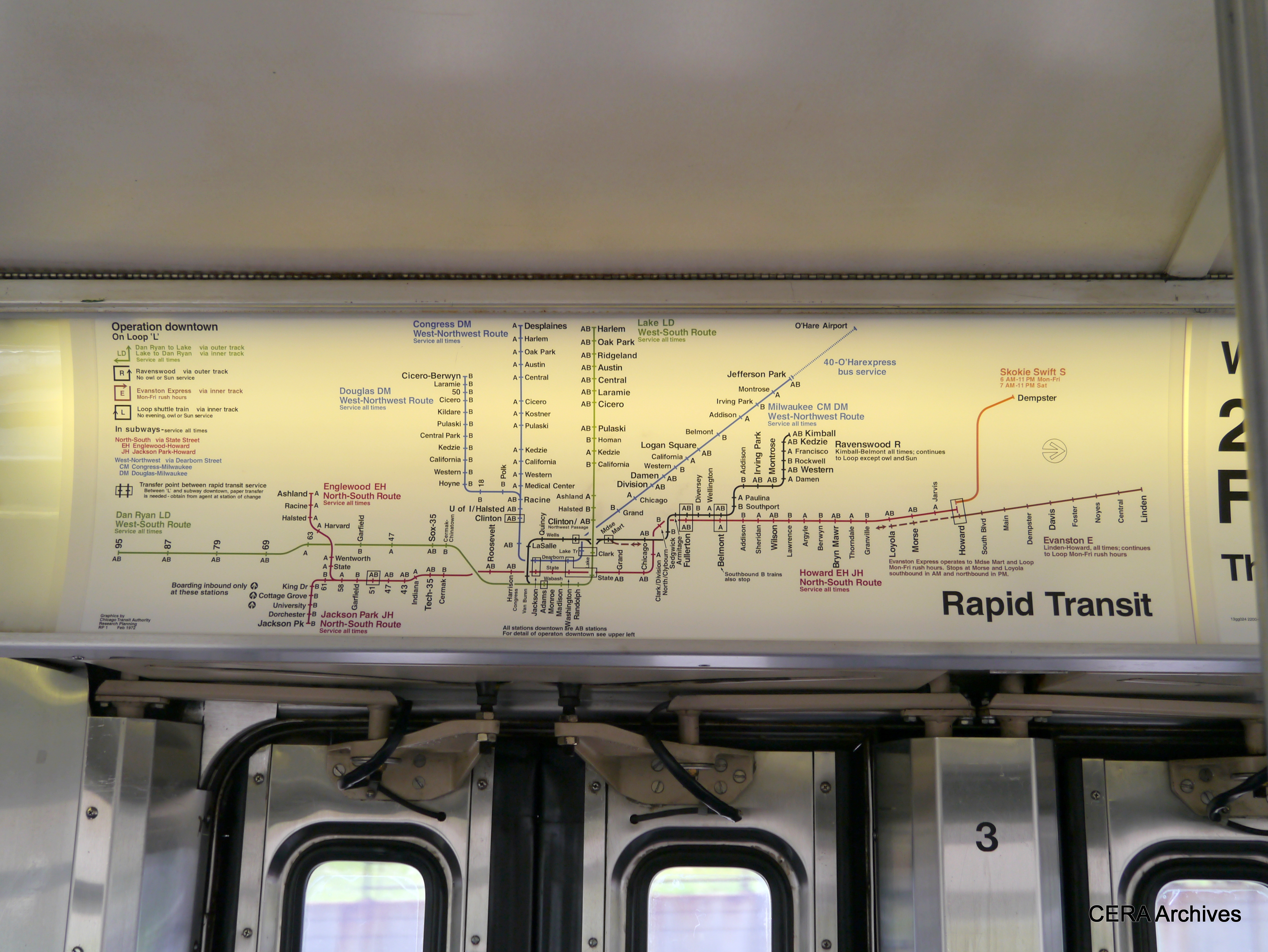
During weekday rush hours, the Evanston Express was the only other route to travel clockwise and use the inner track. Southbound Lake–Dan Ryan trains shared the inner track on the Lake and Wabash segment.

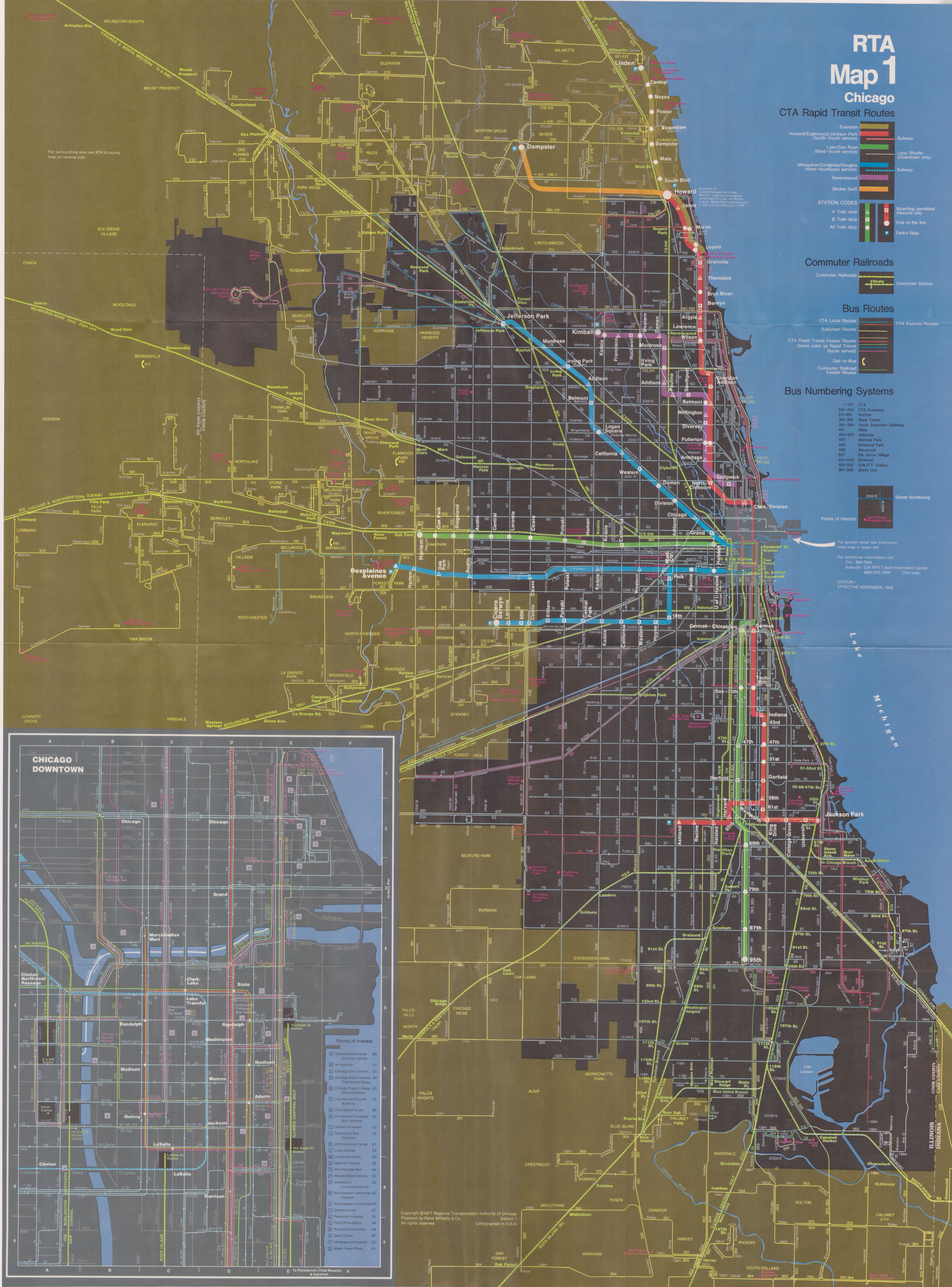
While the CTA did not formally adopt color-coded lines during its lifetime, the Loop Shuttle was depicted as gray or black on color maps. [2] [3]

History

Opportunity for a continuous "L" line around the Loop was realized in 1969, when modifications were underway to allow through service of the Lake Street branch to the newly completed Dan Ryan branch. Prior to this all trains ran counter-clockwise, with Ravenswood and Evanston Express trains using the outer track and Lake Street trains using the inner track. The new Lake–Dan Ryan Line began on September 28, 1969, and Loop Shuttle service began two days later on September 30. The Ravenswood Line would continue operating counter-clockwise via the outer track and Evanston Express trains would shift to operating clockwise around the inner track on September 30.

The Loop Shuttle was quietly discontinued on September 30, 1977 as a cost-cutting measure. [4] After the Loop Shuttle's discontinuation, the Evanston Express remained the only route to run clockwise around the Loop. Full time service around the inner loop was restored with the introduction of the Orange Line in 1993 and later the Pink Line in 2006.

Station listing

StationConnecting "L" services and notes [lower-alpha 1]
Clark/Lake
(inner platform)
  Lake–Dan Ryan    Ravenswood    Evanston Express  
  Milwaukee–Congress–Douglas  (at Lake Transfer)
State/Lake
(inner platform)
  Lake–Dan Ryan    Ravenswood    Evanston Express  
  Howard–Englewood–Jackson Park  (at Washington)
Randolph/Wabash
(inner platform)
  Lake–Dan Ryan    Ravenswood    Evanston Express  
Madison/Wabash
(inner platform)
  Lake–Dan Ryan    Ravenswood    Evanston Express  
Adams/Wabash
(inner platform)
  Lake–Dan Ryan    Ravenswood    Evanston Express  
State/Van Buren
(inner platform)
Closed September 2, 1973
LaSalle/Van Buren
(inner platform)
  Ravenswood    Evanston Express  
Quincy
(inner platform)
  Ravenswood    Evanston Express  
Madison/Wells
(inner platform)
  Ravenswood    Evanston Express  
Randolph/Wells
(inner platform)
  Ravenswood    Evanston Express  
Trains return to Clark/Lake
  1. The Ravenswood Line and Evanston Express exist today as the Brown Line and Purple Line, respectively. During the Loop Shuttle's lifetime they were depicted with "swapped" colors. Additionally, the south portions of today's Red and Green Lines were switched.

Related Research Articles

<span class="mw-page-title-main">Chicago "L"</span> Rapid transit system in Chicago, Illinois, US

The Chicago "L" is the rapid transit system serving the city of Chicago and some of its surrounding suburbs in the U.S. state of Illinois. Operated by the Chicago Transit Authority (CTA), it is the fourth-largest rapid transit system in the United States in terms of total route length, at 102.8 miles (165.4 km) long as of 2014, and the second-busiest rapid transit system in the United States, after the New York City Subway. In 2016, the "L" had 1,492 rail cars, eight different routes, and 145 train stations. In 2022, the system had 103,524,900 rides, or about 322,200 per weekday in the first quarter of 2023.

<span class="mw-page-title-main">Red Line (CTA)</span> Rapid transit line in Chicago

The Red Line is a rapid transit line in Chicago, run by the Chicago Transit Authority (CTA) as part of the Chicago "L" system. It is the busiest line on the "L" system, with an average of 93,457 passengers boarding each weekday in 2022. The route is 26 miles (42 km) long with a total of 33 stations. It runs elevated from the Howard station in the Rogers Park neighborhood on the North Side, through a subway on the Near North Side, Downtown, and the South Loop, and then through the Dan Ryan Expressway median to 95th/Dan Ryan in the Roseland neighborhood on the South Side.

<span class="mw-page-title-main">Orange Line (CTA)</span> Rapid transit line in Chicago, Illinois

The Orange Line is a rapid transit line in Chicago, Illinois, operated by the Chicago Transit Authority (CTA) as part of the Chicago "L" system. It is approximately 13 miles (21 km) long and runs on elevated and at grade tracks and serves the Southwest Side, running from the Loop to Midway International Airport. As of 2022, an average of 15,098 riders board Orange Line trains on weekdays.

<span class="mw-page-title-main">Brown Line (CTA)</span> Rapid transit line in Chicago, Illinois

The Brown Line of the Chicago "L" system, is an 11.4-mile (18.3 km) route with 27 stations between Chicago's Albany Park neighborhood and downtown Chicago. It runs completely above ground and is almost entirely grade-separated. It is the third-busiest 'L' route, with an average of 28,315 passengers boarding each weekday in 2022.

<span class="mw-page-title-main">Green Line (CTA)</span> Rapid transit line, part of the Chicago L system

The Green Line is a rapid transit line in Chicago, Illinois, operated by the Chicago Transit Authority (CTA) as part of the Chicago "L" system. It is the only completely elevated route in the "L" system. All other routes may have various combinations of elevated, subway, street level, or freeway median sections.

<span class="mw-page-title-main">Purple Line (CTA)</span> Rapid transit line run by the Chicago Transit Authority

The Purple Line of the Chicago "L" is a 3.9-mile (6.3 km) route on the northernmost section of the system. The service normally begins from Linden in Wilmette and ends Howard on Chicago’s north border, passing through the city of Evanston.

<span class="mw-page-title-main">Chicago North Shore and Milwaukee Railroad</span> Former interurban railroad line between the Chicago Loop and downtown Milwaukee

The Chicago North Shore and Milwaukee Railroad, also known as the North Shore Line, was an interurban railroad that operated passenger and freight service over an 88.9-mile (143.1 km) route between the Chicago Loop and downtown Milwaukee, as well as an 8.6-mile (13.8 km) branch line between the villages of Lake Bluff and Mundelein, Illinois. The North Shore Line also provided streetcar, city bus and motor coach services along its interurban route.

The Chicago Central Area Transit Plan, generally referred to as the Chicago Central Area Transit Project (CCATP) in the 1970s, was an extensive study of the rapid transit system in downtown Chicago; the study had begun in 1965.

<span class="mw-page-title-main">Pink Line (CTA)</span> Rapid transit line in Chicago, Illinois

The Pink Line is an 11.2 mi (18.0 km) rapid transit line in Chicago, run by the Chicago Transit Authority (CTA) as part of the Chicago "L" system. It is the CTA's newest rail line and began operation for a 180-day trial period on June 25, 2006, running between 54th/Cermak station in Cicero, Illinois and the Loop in downtown Chicago. The route, as the line is about to enter downtown Chicago, shares tracks with Green Line trains on Lake Street. This connection is handled by the previously non-revenue Paulina Connector set of tracks. In 2022, an average of 9,544 passengers boarded Pink Line trains on weekdays.

<span class="mw-page-title-main">1977 Chicago Loop derailment</span> Deadly crash of a rapid transit train in Chicago, Illinois

The 1977 Chicago Loop derailment occurred on February 4, 1977, when a Chicago Transit Authority elevated train rear-ended another on the northeast corner of the Loop at Wabash Avenue and Lake Street during the evening rush hour. The collision forced the first four cars of the rear train off the elevated tracks, killing 11 people and injuring at least 268 as the cars fell onto the street below.

<span class="mw-page-title-main">Fullerton station (CTA)</span> Chicago "L" station

Fullerton is an 'L' station on the CTA's Red and Brown Lines. Purple Line Express trains also stop at the station during weekday rush hours. It is an elevated station with two island platforms, serving four tracks, located in the Lincoln Park neighborhood in Chicago, Illinois. Brown and Purple Line trains share the outer tracks while Red Line trains run on the inner tracks. As well as being an important transfer station, the station serves the Lincoln Park Campus of DePaul University.

<span class="mw-page-title-main">Northwestern Elevated Railroad</span>

The Northwestern Elevated Railroad was the last of the privately constructed rapid transit lines to be built in Chicago. The line ran from the Loop in downtown Chicago north to Wilson Avenue in Chicago's Uptown neighborhood with a branch to Ravenswood and Albany Park that left the main line at Clark Street. The Ravenswood line is now operated as the Brown Line, while the Main Line is used by the Purple and Red Lines.

<span class="mw-page-title-main">Kenwood branch</span> Former Chicago "L" line

The Kenwood branch was a rapid transit line which was part of the Chicago 'L' system from 1907 to 1957. The branch served the Kenwood neighborhood of Chicago and consisted of six elevated stations. It opened on September 20, 1907 and closed on December 1, 1957.

The Lake–Dan Ryan Line was a rail rapid transit route formerly operated by the Chicago Transit Authority (CTA). The Lake–Dan Ryan Line existed from the opening of the Dan Ryan branch on September 28, 1969, until February 21, 1993. When created, the route united two transit corridors that until 1969 never had through rail service. This routing, which became known as the West-South route, operated from the Harlem terminal in Forest Park on the Lake Street "L" through downtown Chicago along the Union Loop "L", and then via the old South Side "L" and the new Dan Ryan Line to the 95th Street Terminal. The Lake–Dan Ryan service was planned in conjunction with the former Franklin Street Connector and Chicago Central Area Transit Project, both of which were never constructed. The section of the route between the junction with the South Side "L" at 17th and State Streets and the Cermak–Chinatown Station was originally an "interim", or temporary facility. It was planned to be torn down when the Loop Subway system was completed, but survived after the project was cancelled in 1979. That section was improved in the 1980s and early 1990s and is currently being used by the Orange Line. Train transfers are possible by using the two unused tracks.

<span class="mw-page-title-main">North Side main line</span>

The North Side Main Line is a branch of the Chicago "L" system that is used by Red, Purple, and Brown Line trains. As of 2012, it is the network's busiest rail branch, serving an average of 123,229 passengers each weekday. The branch is 10.3 miles (16.6 km) long with a total of 21 stations, from Howard Street in Rogers Park down to Lake Street in Chicago's Loop. The branch serves the north side of the city 24 hours a day, seven days a week.

<span class="mw-page-title-main">Roosevelt station (CTA)</span> Chicago "L" station

Roosevelt is an "L" station on the CTA's Red, Green, and Orange Lines, located between the Chicago Loop and the Near South Side in Chicago, Illinois. It is situated at 1167 S State Street, just north of Roosevelt Road. The station is also the closest "L" station to the Museum Campus of Chicago and Soldier Field, which are about 12 mile (800 m) to the east. The Museum Campus/11th Street Metra station is also about 13 mile (500 m) to the east.

<span class="mw-page-title-main">Lake Street Elevated</span> Rapid transit line in Chicago

The Lake Street Elevated, also known as the Lake branch, is a 8.75 mi (14.08 km) long branch of the Chicago "L" which is located west of the Chicago Loop and serves the Green Line for its entire length, as well as the Pink Line east of Ashland Avenue. As of February 2013, the branch serves an average of 27,217 passengers each weekday. It serves the Near West Side, East Garfield Park, West Garfield Park, and Austin neighborhoods of Chicago, as well as the suburbs Oak Park and Forest Park. It owes its name to Lake Street, the street that the branch overlooks for 6.25 mi (10.06 km) before continuing its route straight west, adjacent to South Boulevard, towards the terminus at Harlem/Lake.

<span class="mw-page-title-main">Skip-stop on the Chicago "L"</span> Trains doing only certain stops on a route

The Chicago "L" used skip-stop service, wherein certain trains would stop only at certain designated stations on a route, from 1948 to 1995. It was implemented as a way to speed up travel within a route, and was one of the Chicago Transit Authority's first reforms upon its assumption of the "L"'s operations.

The Randolph Street Branch and Cuyler Avenue Shuttle were two different incarnations of a rapid transit line operated in and around Oak Park, Illinois, a suburb of Chicago, by the Lake Street Elevated intermittently between 1899 and 1912. The Randolph Street Branch served as the line's westward extension to Wisconsin Avenue from Lombard Avenue, whereas the Cuyler Avenue Shuttle was intended to serve the Harlem Race Track. Local opposition resulted in the lines being discontinued.

References

  1. Graham, Garfield. "Chicago L.org: Operations - Lines -> Loop Elevated". www.chicago-l.org. Retrieved 5 October 2022.
  2. Rand McNally & Co. (1977). RTA Map: Chicago & Suburbs (Map) (1st ed.). November 1, 1976. Regional Transportation Authority of Chicago. p. 2.
  3. Chicago Transit Authority Research Planning (February 1972). "L" system car card map (Map). Chicago Transit Authority.
  4. Cudahy, Brian J. (1982). Destination, Loop : the story of rapid transit railroading in and around Chicago (1st ed.). Brattleboro, Vt.: S. Greene Press. ISBN   0-8289-0480-4.