Westchester branch

Last updated
Westchester branch
Overview
StatusDefunct
Locale Forest Park, Illinois
Maywood, Illinois
Bellwood, Illinois
Westchester, Illinois
Termini
Stations9
Service
Type Rapid transit
System Chicago "L"
Operator(s) Chicago Transit Authority (1947–1951)
Chicago Rapid Transit Company (1926–1947)
History
OpenedOctober 1, 1926
ClosedDecember 9, 1951
Technical
Line length5.6 mi (9.0 km)
Track gauge 4 ft 8+12 in (1,435 mm) standard gauge
Electrification Third rail, 600 V DC
Route map
Westchester branch Westchester branch highlighted in gray
BSicon uexCONTg.svg
BSicon GRZq.svg
BSicon WASSERq.svg
BSicon uexhKRZWae+GRZq.svg
BSicon GRZq.svg
BSicon WASSERq.svg
BSicon uexBUE-us.svg
1st Ave.
BSicon uexBUE-us.svg
5th Ave.
BSicon uexBHF.svg
5th Avenue
BSicon uexBUE-us.svg
9th Ave.
BSicon uexBUE-us.svg
BSicon uexBHF.svg
11th Avenue
11th Ave.
BSicon uexBHF.svg
17th Avenue
BSicon uexBUE-us.svg
17th Ave.
BSicon GRZq.svg
BSicon uxSTR+GRZq.svg
BSicon GRZq.svg
Maywood
Bellwood
BSicon uexBHF.svg
25th Avenue
BSicon uexBUE-us.svg
25th Ave.
BSicon DCONTgq.svg
BSicon uxmKRZh.svg
BSicon DCONTfq.svg
BSicon WASSERq.svg
BSicon uexWBRUCKE2.svg
BSicon WASSERq.svg
BSicon uexKRW+l.svg
BSicon uexKRWgr.svg
Bellwood Junction
BSicon uexBUE-us.svg
Bellwood Ave.
BSicon HUBaq.svg
BSicon uexINT.svg
BSicon HUBeq.svg
BSicon uexINT.svg
Bellwood
BSicon uexCONT3+g.svg
BSicon uexSTR.svg
BSicon uexBHF.svg
Harrison
BSicon uexBUE-us.svg
Harrison St.
BSicon GRZq.svg
BSicon uxSTR+GRZq.svg
BSicon lCSTRa@f.svg
BSicon GRZq.svg
Bellwood
Westchester
BSicon DCONTgq.svg
BSicon MSTRq.svg
BSicon uxmKRZh.svg
BSicon uexCSTR.svg
BSicon DCONTfq.svg
BSicon uexKBHFe.svg
BSicon uexnKSTRa.svg
BSicon lCSTRe@f.svg
Roosevelt
BSicon uexlBHF.svg
BSicon uexnSTR.svg
Canterbury
BSicon lBUE-us.svg
BSicon uexnSTR.svg
Canterbury St.
BSicon uexlBHF.svg
BSicon uexnKSTRe.svg
Mannheim/22nd

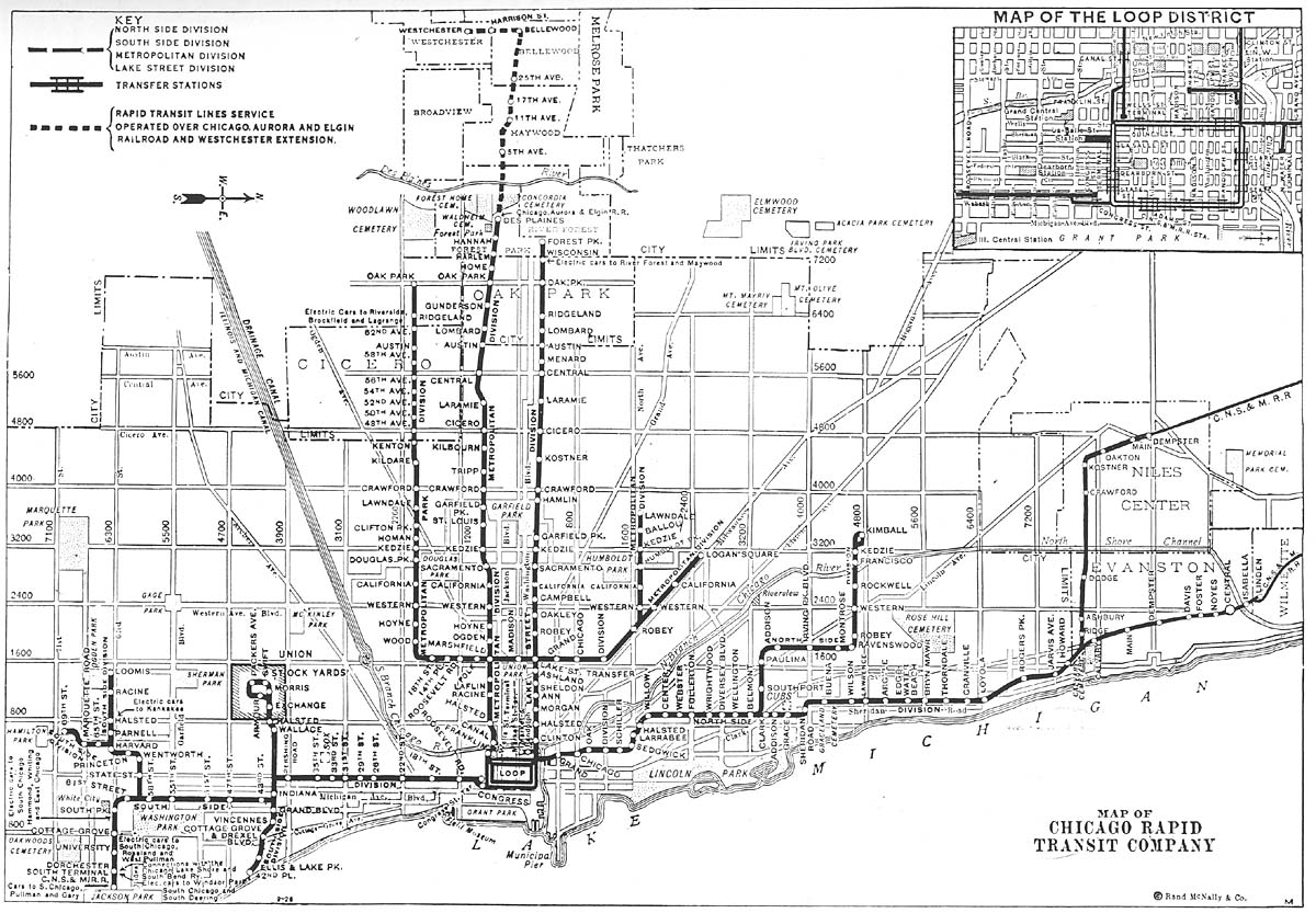
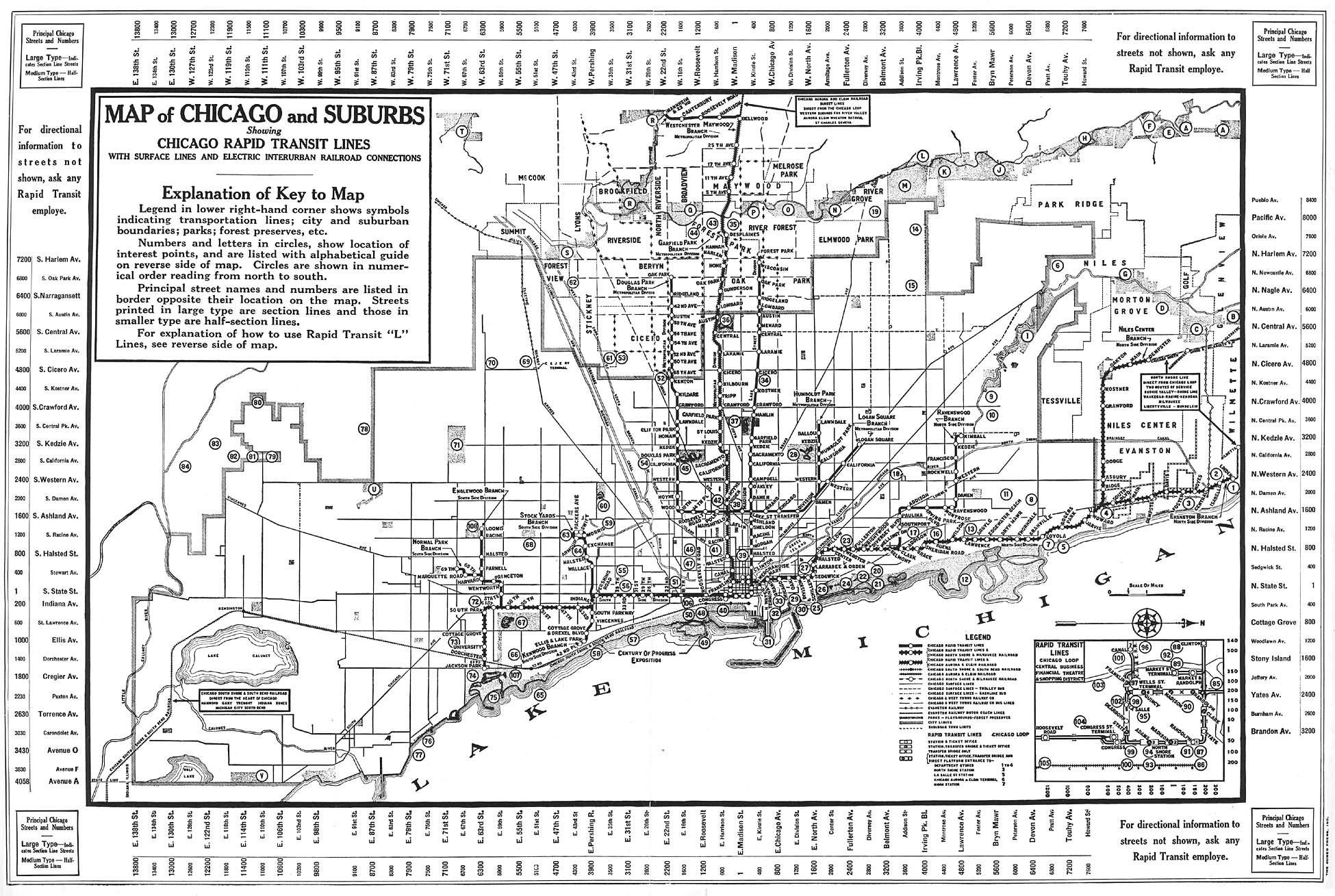
The Westchester branch was a rapid transit line which was part of the Chicago "L" system from 1926 to 1951. The branch served the suburbs of Forest Park, Maywood, Bellwood, and Westchester, and consisted of nine stations. [1] It opened on October 1, 1926, and closed on December 9, 1951. [2]

Contents

Operations

The Westchester branch was 5.6 mi (9.0 km) long, and originated from the Garfield Park Branch at the Des Plaines station in Forest Park, Illinois. Initially the line terminated at Roosevelt Road near Bellwood Avenue. [3] On December 1, 1930, service was extended to Mannheim/22nd. Service on the Westchester branch ended on December 9, 1951, [2] and was replaced by the Westchester bus route (now Pace Route 317), which largely mirrored the route of the Westchester branch, though the bus route only extended as far south as Canterbury Street. [4]

Station listing

Westchester Maywood branch stations [5] [1] [3]
StationLocation
Des Plaines 711 S. Des Plaines Avenue, Forest Park
5th Avenue 5th Avenue near Quincy Street, Maywood
11th Avenue 11th Avenue and South Maywood Drive, Maywood
17th Avenue 17th Avenue and South Maywood Drive, Maywood
25th Avenue 25th Avenue and Maywood Drive, Maywood
Bellwood Bellwood Avenue near Madison Street, Bellwood
Harrison Harrison Street near Bellwood Avenue, Bellwood
Roosevelt Roosevelt Road near Bellwood Avenue, Westchester
Canterbury Canterbury Street near Westchester Boulevard, Westchester
Mannheim/22nd Mannheim Road and 22nd Street, Westchester

Related Research Articles

<span class="mw-page-title-main">Chicago "L"</span> Rapid transit system in Chicago, Illinois, US

The Chicago "L" is the rapid transit system serving the city of Chicago and some of its surrounding suburbs in the U.S. state of Illinois. Operated by the Chicago Transit Authority (CTA), it is the fourth-largest rapid transit system in the United States in terms of total route length, at 102.8 miles (165.4 km) long as of 2014, and the third-busiest rapid transit system in the United States, after the New York City Subway and Washington Metro. In 2016, the "L" had 1,492 rail cars, eight different routes, and 145 train stations. In 2022, the system had 103,524,900 rides, or about 367,000 per weekday in the second quarter of 2023.

<span class="mw-page-title-main">Red Line (CTA)</span> Rapid transit line in Chicago

The Red Line is a rapid transit line in Chicago, run by the Chicago Transit Authority (CTA) as part of the Chicago "L" system. It is the busiest line on the "L" system, with an average of 93,457 passengers boarding each weekday in 2022. The route is 26 miles (42 km) long with a total of 33 stations. It runs elevated from the Howard station in the Rogers Park neighborhood on the North Side, through a subway on the Near North Side, Downtown, and the South Loop, and then through the Dan Ryan Expressway median to 95th/Dan Ryan in the Roseland neighborhood on the South Side.

<span class="mw-page-title-main">Blue Line (CTA)</span> West-Northwest section of Chicago Rail System (L)

The Blue Line is a 26.93-mile-long (43.34 km) Chicago "L" line which extends through The Loop from O'Hare International Airport at the far northwest end of the city, through downtown via the Milwaukee–Dearborn subway and across the West Side to its southwest end at Forest Park, with a total of 33 stations. At about 27 miles, it is the longest line on the Chicago "L" system and second busiest, and one of the longest local subway/elevated lines in the world. It has an average of 64,978 passengers boarding each weekday in 2021.

<span class="mw-page-title-main">Boston-area streetcar lines</span>

As with many large cities, a large number of Boston-area streetcar lines once existed, and many continued operating into the 1950s. However, only a few now remain, namely the four branches of the Green Line and the Ashmont–Mattapan High-Speed Line, with only one running regular service on an undivided street.

The IRT Pelham Line is a rapid transit line on the New York City Subway, operated as part of the A Division and served by the 6 and <6> trains. It was built as part of the Dual Contracts expansion and opened between 1918 and 1920. It is both elevated and underground with Whitlock Avenue being the southernmost elevated station. It has three tracks from the beginning to just south of the Pelham Bay Park terminal. The Pelham Line also has a connection to Westchester Yard, where 6 trains are stored, just north of Westchester Square–East Tremont Avenue. As of 2013, it has a daily ridership of 205,590.

<span class="mw-page-title-main">Wonderland station</span> Rapid transit station in Revere, Massachusetts, US

Wonderland station is a transit station in Revere, Massachusetts located adjacent to Revere Beach. It is the northern terminus of the MBTA Blue Line rapid transit line, as well as a major bus transfer station for Revere and the North Shore area, serving MBTA bus routes 110, 116, 117, 411, 424, 426W, 439, 441, 442, 450W, and 455. The station is fully accessible.

<span class="mw-page-title-main">Western station (CTA Blue Line O'Hare branch)</span> Chicago rapid transit station

Western is an elevated rapid transit station on the Chicago "L"'s Blue Line, where it is located on the O'Hare branch. The station, opened in 1895, is located within the Bucktown neighborhood in the larger Logan Square community area. It has two side platforms at track level with a station house at street level.

<span class="mw-page-title-main">Damen station (CTA Blue Line)</span> Rapid transit station in Chicago

Damen is a rapid transit station on the Chicago "L", currently serving the O'Hare branch of its Blue Line. Opened on May 6, 1895, as Robey, it is the oldest station on the Blue Line. The station serves the popular Bucktown and Wicker Park neighborhoods, and is consistently in the top 40 highest-ridership "L" stations. It has two wooden side platforms and a brick station house at street level. The west platform, serving southbound trains, contains a tower that has never been used but is a relic of the station's past. The station is served by three bus routes on Damen, Milwaukee, and North Avenues, which are each descended from streetcar lines on those streets in the early 20th century. The Blue Line has owl service; while the surrounding streetcar lines also had owl service in the early 20th century, the modern bus services do not.

<span class="mw-page-title-main">Forest Park station</span> Rapid transit station in Chicago

Forest Park is a station on the Chicago Transit Authority's 'L' system, located in the village of Forest Park, Illinois and serving the Blue Line. Before the Congress Line was built, it served as terminal for the Garfield Line. It is the western terminus of the Forest Park branch. The station was known as Des Plaines until 1994. It is also referred to as the Forest Park Transit Center by Pace because it is a major terminal for Pace buses. The station contains a 1051-space Park and Ride lot which uses the "Pay and Display" system, in which fees are paid at the lot entrance. It is located south of the Baltimore and Ohio Chicago Terminal Railroad tracks which curve to the north of the station towards Madison Street where the line rechristens itself to the Canadian National Railway's Waukesha Subdivision.

<span class="mw-page-title-main">Dan Ryan branch</span>

The Dan Ryan branch is a 9.4 mi (15.1 km) long section of the Chicago "L" system located on the South Side of Chicago, Illinois. It is operated by the Chicago Transit Authority, as part of its Red Line service and is normally through-routed downtown towards the North Side via the State Street subway. As of February 2013, the branch serves 45,355 passengers per weekday. As part of the CTA's busiest rapid transit line, it is operated 24 hours a day, 365 days a year. The branch serves the Chinatown, Armour Square, Fuller Park, Englewood, Greater Grand Crossing, Chatham and Roseland neighborhoods.

<span class="mw-page-title-main">Cermak branch</span>

The Cermak branch, formerly known as the Douglas branch, is a 6.6 mi (10.6 km) long section of the Pink Line of the Chicago "L" system in Chicago, Illinois. It was built by the Metropolitan West Side Elevated west of the Loop. As of February 2013, it serves an average of 17,474 passengers every weekday. The branch serves the Near West Side, Pilsen, Lower West Side, South Lawndale, and North Lawndale neighborhoods of Chicago, and the west suburb Cicero, Illinois. The branch operates from 4:05 a.m. to 1:25 a.m., weekdays, and Saturdays from 5:05 a.m. to 1:25 a.m., and Sundays from 5:00 a.m. to 1:25 a.m., including holidays.

The Garfield Park Branch was a rapid transit line which was part of the Chicago "L" system from 1895 to 1958. The branch served Chicago's Near West Side, East Garfield Park, West Garfield Park, and Austin neighborhoods, and the suburbs of Oak Park, and Forest Park, and consisted of twenty-two stations. It opened on June 19, 1895 and closed on June 22, 1958, when it was replaced by the Congress branch of the Blue Line.

<span class="mw-page-title-main">Marshfield station</span> Rapid transit station in Chicago, 1895–1954

Marshfield was a rapid transit station on the Chicago "L". Constructed by the Metropolitan West Side Elevated Railroad, it was the westernmost station of the Metropolitan's main line, which then diverged into three branches: the northwestern Logan Square branch, the western Garfield Park branch, and the southwestern Douglas Park branch. The station was in service from 1895 to 1954, when it was demolished, alongside the main line and the Garfield Park branch, to make way for the Eisenhower Expressway and rapid-transit Congress Line in its median. In addition to its use on the "L", Marshfield was served by the Chicago Aurora and Elgin Railroad (CA&E), an interurban that used the Garfield Park branch and main line's tracks, between 1905 and 1953.

<span class="mw-page-title-main">Laflin station</span> Rapid transit station in Chicago, 1895–1951

Laflin was a rapid transit station operated by the Chicago "L"'s Metropolitan West Side Elevated Railroad and located on its main line. The station existed from 1895 to 1951, when it was closed due to low ridership. The entire main line would soon be demolished for construction of the Eisenhower Expressway and its Congress Line, and the niche served by the Laflin would be filled by an entrance on the new line's Racine station.

Division was a rapid transit station on the Chicago "L"'s Logan Square branch, one of several branches of the Metropolitan West Side Elevated Railroad. Located on Division Street, the station was constructed by the Metropolitan in the early 1890s and began service on May 6, 1895.

Bellwood was a station on the Chicago Aurora and Elgin Railroad (CA&E) serving Bellwood, Illinois, from 1902 to 1957. An adjacent station, serving the Westchester branch, existed for rapid transit purposes on the Chicago "L" between 1926 and 1951.

Roosevelt, originally known as Westchester, was a rapid transit station that served the Westchester branch of the Chicago "L" between 1926 and the branch's discontinuation in 1951. It was the branch's terminus from its opening until the 1930 extension of the line to 22nd Street.

Mannheim/22nd was a rapid transit station on the Chicago "L" between 1930 and 1951. Located on the Westchester branch, it was the southern terminus of that branch, which was extended south to the station's location after having opened in 1926.

Canterbury was a rapid transit station on the Chicago "L" between 1930 and 1951. Located on the Westchester branch, it was part of a southern extension of the branch, which had opened in 1926.

References

  1. 1 2 'L' Map of Chicago (Map). Chicago Rapid Transit Company. 1934. Retrieved August 18, 2013.
  2. 1 2 "Westchester branch". Chicago "L".org. Retrieved August 18, 2013.
  3. 1 2 Map of Chicago Rapid Transit Company (Map). Chicago Rapid Transit Company. 1926. Retrieved August 18, 2013.
  4. Chicago Transit Map (Map). Chicago Transit Authority. 1954. Retrieved August 18, 2013.
  5. Chicago Map Showing Rapid Transit Lines (Map). Chicago Rapid Transit Company. 1933. Retrieved August 18, 2013.