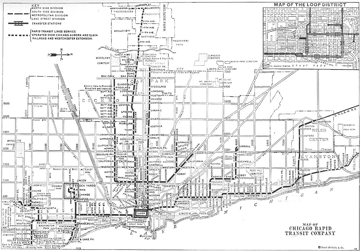
Humboldt Park branch

Last updated
Humboldt Park branch
Overview
StatusClosed
Locale Chicago, Illinois, U.S.
Termini
Stations6
Service
Type Rapid transit
System Chicago 'L'
Operator(s) Chicago Transit Authority (1947–1952)
Chicago Rapid Transit Company (1924–1947)
Metropolitan West Side Elevated Railroad (1895–1924)
History
OpenedJuly 29, 1895
ClosedMay 4, 1952
Technical
Line length2.09 mi (3.36 km)
CharacterElevated
Track gauge 4 ft 8+12 in (1,435 mm)
Electrification Third rail, 600 V DC
Route map
Humboldt Park branch Humboldt Park branch highlighted in gray
BSicon uexhKBHFa.svg
Lawndale
BSicon uexhBHF.svg
St. Louis
BSicon uexhBHF.svg
Kedzie
BSicon uexhBHF.svg
Humboldt Park
BSicon uexhBHF.svg
California
BSicon uexhBHF.svg
Western
BSicon uxhSTR+hc2.svg
BSicon uhCONT3.svg
BSicon uxhABZg+1.svg
BSicon uhSTRc4.svg
BSicon uhBHF.svg
Damen
BSicon uexhSTRc2.svg
BSicon uehABZg3.svg
Evergreen Junction
BSicon uexhCONT1.svg
BSicon uehtSTRa+hc4.svg
BSicon utCONTf.svg

The Humboldt Park branch was a rapid transit line which was part of the Chicago "L" system from 1895 to 1952. The branch served the West Town and the Humboldt Park neighborhoods of Chicago and consisted of six elevated stations. It opened on July 29, 1895, and closed on May 4, 1952.

Contents

Operations

The Humboldt Park branch was a 2.09-mile (3.36 km) elevated line which served six stations. The branch separated from the Logan Square branch northwest of the Damen station (originally called Robey), and ended at the Lawndale terminus. [1] It ran immediately north of North Avenue between Hoyne Avenue and Lawndale Avenue. [2]

History

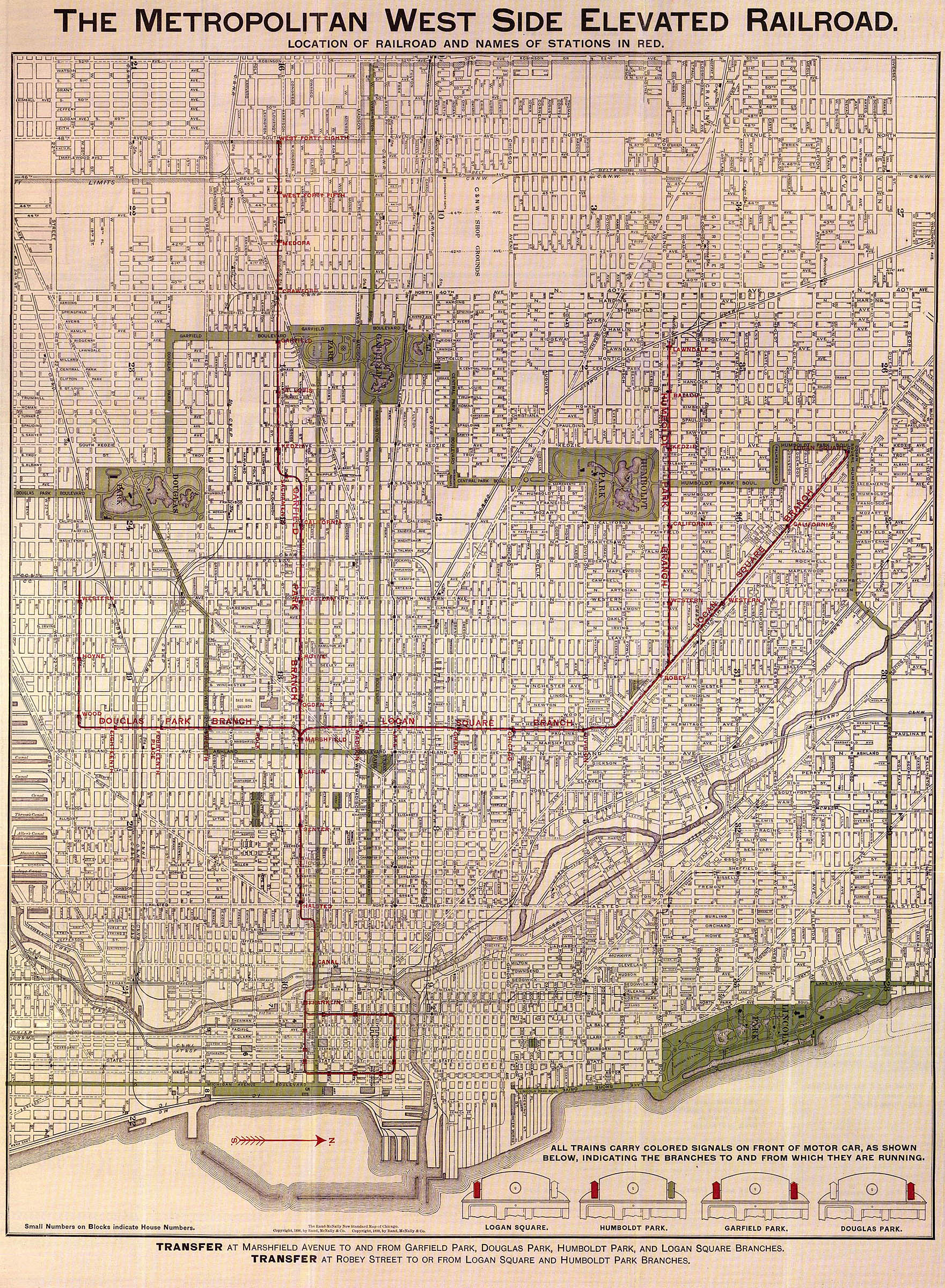
The Humboldt Park branch had initially been intended to run to Harlem Avenue, a length of 6.5-mile (10.5 km), although this never came to be due to that area being less developed in 1895, and Lawndale Avenue remained the branch's terminus for the duration of the branch's existence. [3] The Humboldt Park branch initially had only five stops, [2] until 1902 when a sixth stop opened at Humboldt Park Boulevard. [4] In 1906, the Chicago city council approved the Met's proposal to extend the branch westward to Harlem Avenue, running on an elevated structure to 52nd Avenue and then at ground level from there to Harlem Avenue, but construction was never implemented, even though said extension likely would have given the branch the ridership levels needed to maintain service after 1952. [3]

For the larger part of its service life, the Humboldt Park Branch was operated as a shuttle between Damen and Lawndale. For the first ten years, until 1904 when the Met converted their trains to multiple-unit operation, Humboldt trains only ran downtown via the Paulina Connector and Marshfield Junction during rush hours. Late night service operated as single car shuttles on the branch, and during off-peak hours, motor cars pushed trailers to Damen that were then coupled onto Logan Square trains for the trip downtown, and the process reversed on the outbound trip.

In 1930, during the Great Depression, all stations on the Met branches were lengthened to accommodate eight car trains, including the Humboldt branch. During off-peak hours, the procedure of coupling Humboldt cars to Logan Square trains at Damen continued. During rush hours, Logan Square and Humboldt trains ran downtown, providing skip-stop service between Damen and Marshfield Junction. [3]

Abandonment

The beginning of the end for the Humboldt Park branch was in 1947 when the CTA was formed to take over from the ailing Chicago Rapid Transit. Compared to their predecessor, the CTA intended to change things by adjusting the 'L' services to adapt to changing ridership patterns. The Humboldt Park branch was one line that they targeted for abandonment as early as 1949, but political pressure forced them to hold off. [3]

In August 1948, the CTA discontinued the practice of coupling Humboldt cars to Logan Square trains at Damen. Effective August 29th, off-peak Humboldt Park service was reduced to a shuttle between Damen and Lawndale. To provide a timed transfer to Logan Square trains to downtown, Humboldt cars were scheduled to arrive right before Loop-bound Logan Square trains, discharge and board new passengers, then cross back over to the outbound track and return to the branch. Rush hour through service was retained, although now all Logan Square trains serviced the Loop while Humboldt trains terminated at Wells Street Terminal.

The 1950s brought bigger changes that would lead to the branch's abandonment. The first was on February 19, 1950, when the CTA discontinued evening and owl service. While minor, a bigger change happened in December of that year when the Logan Square branch was re-equipped with the 6000-series cars, whereas the Humboldt branch continued to use older wood cars. This led to a decline in Humboldt ridership as passengers preferred to go to Logan Square to ride trains with the newer cars.

In 1951, the CTA made plans to close the Humboldt Park branch alongside the rerouting of Logan Square trains into the Milwaukee-Dearborn Subway. However, protests by aldermen and local residents pressured the CTA into keeping the branch in operation. Regardless, the opening of the subway on February 25 was the nail in the coffin for the Humboldt Park Branch. All Logan Square trains were rerouted via the subway, while the elevated tracks from Evergreen Junction (where the subway portal is located) to Marshfield Junction were taken out of revenue operation. As wooden cars were forbidden from operating in the subway due to fire safety concerns, Humboldt Park service was cut off from downtown, and reduced to a full-time Lawndale-Damen shuttle. In the interest of efficiency, the Humboldt trains no longer discharged passengers onto the inbound platform at Damen for a same-platform transfer to the Logan Square branch, but instead now boarded and discharged at a new temporary platform that was constructed over the inbound trackway at the junction where the two branches met, with a new walkway being built at track level to connect the shuttle platform to the inbound platform on the main line. At Damen Junction, the tracks were reconfigured with a spring-and-return switch that merged the eastbound and westbound tracks just before the shuttle platform.

With ridership declines, and in spite of protests, service on the Humboldt Park branch ended on May 4, 1952. The line was demolished in 1953 from Lawndale terminal to Oakley Avenue. A three block stub between the Congress-Milwaukee tracks and Oakley Avenue remained intact for car storage including the shuttle platform until the late 1960s, when the Paulina Connector tracks from Evergreen Portal to Lake Street were demolished. Remnants of the junction were still visible in the structure at North Avenue until 1996 when the spans were replaced as part of renovation work on the Blue Line. [3]

Station listing

Humboldt Park branch stations [1] [2]
StationLocation
Western Western Avenue and North Avenue
California California Avenue and North Avenue
Humboldt Park Humboldt Blvd. and North Avenue
Kedzie Kedzie Avenue and North Avenue
St. Louis (originally Ballou)St. Louis Avenue and North Avenue
Lawndale Lawndale Avenue and North Avenue

Related Research Articles

<span class="mw-page-title-main">Chicago "L"</span> Rapid transit system in Chicago, Illinois, US

The Chicago "L" is the rapid transit system serving the city of Chicago and some of its surrounding suburbs in the U.S. state of Illinois. Operated by the Chicago Transit Authority (CTA), it is the fourth-largest rapid transit system in the United States in terms of total route length, at 102.8 miles (165.4 km) long as of 2014, and the third-busiest rail mass transit system in the United States, after the New York City Subway and Washington Metro. In 2016, the "L" had 1,492 rail cars, eight different routes, and 145 train stations. In 2021, the system had 78,623,200 rides, or about 351,100 per weekday in the third quarter of 2022.

<span class="mw-page-title-main">Blue Line (CTA)</span> West-Northwest section of Chicago Rail System (L)

The Blue Line is a 26.93-mile-long (43.34 km) Chicago "L" line which extends through The Loop from O'Hare International Airport at the far northwest end of the city, through downtown via the Milwaukee–Dearborn subway and across the West Side to its southwest end at Forest Park, with a total of 33 stations. At about 27 miles, it is the longest line on the Chicago "L" system and second busiest, and one of the longest local subway/elevated lines in the world. It has an average of 47,120 passengers boarding each weekday in 2021.

<span class="mw-page-title-main">Wells Street Terminal</span> Rail terminal in Chicago, 1904–1953

Wells Street Terminal was a stub-end downtown terminal on the 'L' in Chicago, Illinois, located at Wells Street between Jackson Boulevard and Van Buren Street. The terminal was in operation from 1904 to 1953.

<span class="mw-page-title-main">Pink Line (CTA)</span> Rapid transit line in Chicago, Illinois

The Pink Line is an 11.2 mi (18.0 km) rapid transit line in Chicago, run by the Chicago Transit Authority (CTA) as part of the Chicago "L" system. It is the CTA's newest rail line and began operation for a 180-day trial period on June 25, 2006, running between 54th/Cermak station in Cicero, Illinois and the Loop in downtown Chicago. The route, as the line is about to enter downtown Chicago, shares tracks with Green Line trains on Lake Street. This connection is handled by the previously non-revenue Paulina Connector set of tracks. In 2021, an average of 7,779 passengers boarded Pink Line trains on weekdays.

<span class="mw-page-title-main">Montrose station (CTA Brown Line)</span> Chicago "L" station

Montrose is a station on the Chicago Transit Authority's 'L' system. It is situated between the Damen and Irving Park stations on the Brown Line, which runs between Albany Park on Chicago's Northwest Side and downtown Chicago. It is an elevated station with two side platforms located at 1817 West Montrose Avenue in the Ravenswood neighborhood of Chicago's Lincoln Square community area.

<span class="mw-page-title-main">Western station (CTA Blue Line O'Hare branch)</span> Chicago rapid transit station

Western is an elevated rapid transit station on the Chicago "L"'s Blue Line, where it is located on the O'Hare branch. The station, opened in 1895, is located within the Bucktown neighborhood in the larger Logan Square community area. It has two side platforms at track level with a station house at street level.

<span class="mw-page-title-main">Damen station (CTA Blue Line)</span> Rapid transit station in Chicago

Damen is an elevated rapid transit station on the Chicago "L", currently serving the O'Hare branch of its Blue Line. Opened on May 6, 1895, as Robey, it is the oldest station on the Blue Line. The station serves the popular Bucktown and Wicker Park neighborhoods, and is consistently in the top 40 highest-ridership "L" stations. It has two wooden side platforms and a brick station house at street level. The west platform, serving southbound trains, contains a tower that has never been used but is a relic of the station's past.

<span class="mw-page-title-main">Metropolitan West Side Elevated Railroad</span> Former Rapid Transit operator

The Metropolitan West Side Elevated Railroad was the third elevated rapid transit line to be built in Chicago, Illinois and was the first of Chicago’s elevated lines to be electrically powered. The main line ran from downtown Chicago to Marshfield Avenue with branches to Logan Square, Humboldt Park, Garfield Park, and Douglas Park. Portions of the system are still operated as sections of the Blue Line and the Pink Line.

<span class="mw-page-title-main">Metropolitan main line</span> Former rapid transit line in Chicago

The Metropolitan main line was a rapid transit line of the Chicago "L" system from 1895 to 1958. It ran west from downtown to a junction at Marshfield station. At this point the Garfield Park branch continued westward, while the Douglas Park branch turned south, and the Logan Square branch turned north with the Humboldt Park branch branching from it. In addition to serving the Chicago "L", its tracks and those of the Garfield Park branch also carried the Chicago Aurora and Elgin Railroad, an interurban that served Chicago's western suburbs, between 1905 and 1953.

<span class="mw-page-title-main">Cermak branch</span>

The Cermak branch, formerly known as the Douglas branch, is a 6.6 mi (10.6 km) long section of the Pink Line of the Chicago "L" system in Chicago, Illinois. It was built by the Metropolitan West Side Elevated west of the Loop. As of February 2013, it serves an average of 17,474 passengers every weekday. The branch serves the Near West Side, Pilsen, Lower West Side, South Lawndale, and North Lawndale neighborhoods of Chicago, and the west suburb Cicero, Illinois. The branch operates from 4:05 a.m. to 1:25 a.m., weekdays, and Saturdays from 5:05 a.m. to 1:25 a.m., and Sundays from 5:00 a.m. to 1:25 a.m., including holidays.

The Garfield Park Branch was a rapid transit line which was part of the Chicago "L" system from 1895 to 1958. The branch served Chicago's Near West Side, East Garfield Park, West Garfield Park, and Austin neighborhoods, and the suburbs of Oak Park, and Forest Park, and consisted of twenty-two stations. It opened on June 19, 1895 and closed on June 22, 1958, when it was replaced by the Congress branch of the Blue Line.

<span class="mw-page-title-main">Logan Square branch</span> Rapid transit line in Chicago

The Logan Square branch was an elevated rapid transit line of the Chicago "L", where it was one of the branches of the Metropolitan West Side Elevated Railroad. Diverging north from the Metropolitan's main line west of Marshfield station, it opened in 1895 and served Chicago's Logan Square and West Town neighborhoods. North of Damen station, the Humboldt Park branch diverged from the Logan Square branch, going west to serve Humboldt Park. The original Logan Square branch was separated into several sections in 1951, some of which remain in revenue service as of 2023.

<span class="mw-page-title-main">Lake Street Transfer station</span> Rapid transit station in Chicago (1913–1951)

The Lake Street Transfer station was a rapid transit station on the Chicago "L", serving as a transfer station between its Lake Street Elevated Railroad and the Logan Square branch of its Metropolitan West Side Elevated Railroad. Located where the Logan Square branch crossed over the Lake Street Elevated, it was in service from 1913 to 1951, when it was rendered obsolete by the construction of the Dearborn Street subway.

<span class="mw-page-title-main">Marshfield station</span> Rapid transit station in Chicago, 1895–1954

Marshfield was a rapid transit station on the Chicago "L". Constructed by the Metropolitan West Side Elevated Railroad, it was the westernmost station of the Metropolitan's main line, which then branched into three branches: the northwestern Logan Square branch, the western Garfield Park branch, and the southwestern Douglas Park branch. The station was in service from 1895 to 1954, when it, alongside the main line and the Garfield Park branch, was demolished to make way for the Eisenhower Expressway and the rapid transit Congress Line in its median. In addition to its use on the "L", Marshfield was served by the Chicago Aurora and Elgin Railroad (CA&E), an interurban that used the Garfield Park branch and main line's tracks, between 1905 and 1953.

<span class="mw-page-title-main">Madison station (CTA)</span> Rapid transit station in Chicago, 1895–1951

Madison was a rapid transit station on the Chicago "L"'s Metropolitan West Side Elevated Railroad, serving its Logan Square branch from 1895 to 1951. The Metropolitan was one of four founding companies of the "L", and the first of its lines to be powered by electricity. The "L"'s companies merged operations under Chicago Elevated Railways (CER) in 1911 and formally merged into the Chicago Rapid Transit Company (CRT) in 1924. Private ownership of the "L" ended in 1947 when the public Chicago Transit Authority (CTA) assumed operations.

Laflin was a rapid transit station operated by the Chicago "L"'s Metropolitan West Side Elevated Railroad and located on its main line. The station existed from 1895 to 1951, when it was closed due to low ridership. The entire main line would soon be demolished for construction of the Eisenhower Expressway and its Congress Line, and the niche served by the Laflin would be filled by an entrance on the new line's Racine station.

Canal was a rapid transit station located on the Metropolitan main line of the Chicago "L". It was in service from 1895 to 1958, when the entire main line was replaced by the Congress Line located in the median of the nearby Eisenhower Expressway. Starting in 1927, the interurban Chicago Aurora and Elgin Railroad (CA&E) also served the station, continuing until 1953. The station connected with Chicago's Union Station, which was one of the city's rail terminals.

Division was a rapid transit station on the Chicago "L"'s Logan Square branch, one of several branches of the Metropolitan West Side Elevated Railroad. Located on Division Street, the station was constructed by the Metropolitan in the early 1890s and began service on May 6, 1895.

Chicago was a rapid transit station on the Chicago "L"'s Logan Square branch, one of the several branches of the Metropolitan West Side Elevated Railroad, between 1895 and 1951. Located on Chicago Avenue, the station was constructed by the Metropolitan in the early 1890s and began service on May 6, 1895.

Grand was a rapid transit station on the Chicago "L"'s Logan Square branch, one of the several branches of the Metropolitan West Side Elevated Railroad. Located on Grand Avenue, the station was constructed by the Metropolitan in the early 1890s and began service on May 6, 1895.

References

  1. 1 2 Map of Chicago Rapid Transit Company (Map). Chicago Rapid Transit Company. 1926. Retrieved August 16, 2013.
  2. 1 2 3 The Metropolitan West Side Elevated Railroad Metropolitan West Side Elevated Railroad. 1898. Accessed August 16, 2013
  3. 1 2 3 4 5 Humboldt Park branch Chicago "L".org. Accessed August 16, 2013
  4. Humboldt Park (3000W/1600N) Chicago "L".org. Accessed August 16, 2013