
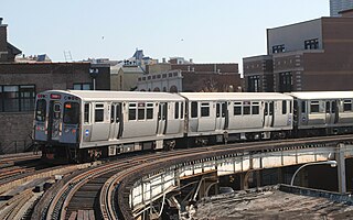
The Chicago "L" is the rapid transit system serving the city of Chicago and some of its surrounding suburbs in the U.S. state of Illinois. Operated by the Chicago Transit Authority (CTA), it is the fourth-largest rapid transit system in the United States in terms of total route length, at 102.8 miles (165.4 km) long as of 2014, and the third-busiest rapid transit system in the United States, after the New York City Subway and Washington Metro. In 2016, the "L" had 1,492 rail cars, eight different routes, and 145 train stations. In 2022, the system had 103,524,900 rides, or about 367,000 per weekday in the second quarter of 2023.
The Red Line is a rapid transit line in Chicago, run by the Chicago Transit Authority (CTA) as part of the Chicago "L" system. It is the busiest line on the "L" system, with an average of 93,457 passengers boarding each weekday in 2022. The route is 26 miles (42 km) long with a total of 33 stations. It runs elevated from the Howard station in the Rogers Park neighborhood on the North Side, through a subway on the Near North Side, Downtown, and the South Loop, and then through the Dan Ryan Expressway median to 95th/Dan Ryan in the Roseland neighborhood on the South Side.

The Blue Line is a 26.93-mile-long (43.34 km) Chicago "L" line which extends through The Loop from O'Hare International Airport at the far northwest end of the city, through downtown via the Milwaukee–Dearborn subway and across the West Side to its southwest end at Forest Park, with a total of 33 stations. At about 27 miles, it is the longest line on the Chicago "L" system and second busiest, and one of the longest local subway/elevated lines in the world. It has an average of 64,978 passengers boarding each weekday in 2022.

The Green Line is a rapid transit line in Chicago, Illinois, operated by the Chicago Transit Authority (CTA) as part of the Chicago "L" system. It is the only completely elevated route in the "L" system. All other routes may have various combinations of elevated, subway, street level, or freeway median sections.

Howard is an 'L' station in Chicago, Illinois. It is the northern terminus of the Red Line and the southeastern terminus of the Yellow Line; it also serves the Purple Line, for which it is the southern terminus at non-rush hour times on weekdays and all day on weekends. Trains on the Chicago North Shore and Milwaukee Railroad also stopped at Howard from 1926 until that line was abandoned in 1963.

The Loop is the 1.79-mile (2.88 km) long circuit of elevated rail that forms the hub of the Chicago "L" system in the United States. As of 2022, the branch served 31,893 passengers every weekday. The Loop is so named because the elevated tracks loop around a rectangle formed by Lake Street, Wabash Avenue (east), Van Buren Street (south), and Wells Street (west). The railway loop has given its name to Chicago's downtown, which is also known as the Loop.

The South Side Elevated Railroad was the first elevated rapid transit line in Chicago, Illinois. The line ran from downtown Chicago to Jackson Park, with branches to Englewood, Normal Park, Kenwood, and the Union Stock Yards. The first 3.6 miles (5.8 km) of the line opened on June 6, 1892. Much of its route is still used today as part of the Green Line of the Chicago "L" system.

Morgan is a rapid transit station on the Chicago "L"'s Green and Pink Lines in Chicago's Near West Side neighborhood. The current station opened at this location in 2012, where a previous station stood from 1893 to 1949.
29th was a rapid transit station on the Chicago "L"'s South Side main line. Originally constructed by the South Side Elevated Railroad company, it was one of the original ten stations opened on the Chicago "L", beginning service on June 6, 1892. The South Side Elevated Railroad merged operations with three other companies to form Chicago Elevated Railways (CER) in 1911, before merging outright with them in 1924 to form the Chicago Rapid Transit Company (CRT). Public ownership came to the "L" in 1947 with the Chicago Transit Authority (CTA).

The Kenwood branch was a rapid transit line which was part of the Chicago 'L' system from 1907 to 1957. The branch served the Kenwood neighborhood of Chicago and consisted of six elevated stations. It opened on September 20, 1907 and closed on December 1, 1957.

The Metropolitan main line was a rapid transit line of the Chicago "L" system from 1895 to 1958. It ran west from downtown to a junction at Marshfield station. At this point the Garfield Park branch continued westward, while the Douglas Park branch turned south, and the Logan Square branch turned north with the Humboldt Park branch branching from it. In addition to serving the Chicago "L", its tracks and those of the Garfield Park branch also carried the Chicago Aurora and Elgin Railroad, an interurban that served Chicago's western suburbs, between 1905 and 1953.

The Ravenswood branch is a 4.7 mi (7.6 km) long branch of the Chicago "L" in Chicago, Illinois. Operated by the Chicago Transit Authority, it carries the Brown Line. As of February 2013, an average of 30,949 passengers are served each weekday on this branch.
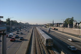
The Dan Ryan branch is a 9.4 mi (15.1 km) long section of the Chicago "L" system located on the South Side of Chicago, Illinois. It is operated by the Chicago Transit Authority, as part of its Red Line service and is normally through-routed downtown towards the North Side via the State Street subway. As of February 2013, the branch serves 45,355 passengers per weekday. As part of the CTA's busiest rapid transit line, it is operated 24 hours a day, 365 days a year. The branch serves the Chinatown, Armour Square, Fuller Park, Englewood, Greater Grand Crossing, Chatham and Roseland neighborhoods.
The South Side Elevated is a branch of the Chicago "L" system in Chicago, Illinois that is served by the Green Line. It has on average 12,509 passengers, counting branch divisions, boarding each weekday as of February 2013, according to the Chicago Transit Authority. The branch is 6.5 miles (10.5 km) long with a total of 8 stations, and runs from the Near South Side to the Washington Park neighborhood of Chicago.
The Humboldt Park branch was a rapid transit line which was part of the Chicago "L" system from 1895 to 1952. The branch served the West Town and the Humboldt Park neighborhoods of Chicago and consisted of six elevated stations. It opened on July 29, 1895, and closed on May 4, 1952.
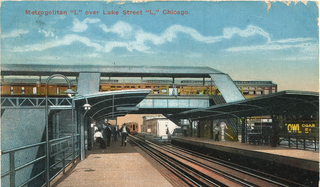
The Lake Street Transfer station was a rapid transit station on the Chicago "L", serving as a transfer station between its Lake Street Elevated Railroad and the Logan Square branch of its Metropolitan West Side Elevated Railroad. Located where the Logan Square branch crossed over the Lake Street Elevated, it was in service from 1913 to 1951, when it was rendered obsolete by the opening of the Dearborn Street subway.

Halsted was a rapid transit station located on the Metropolitan main line of the Chicago "L". It was in existence from 1895 to 1958, when the entire main line was replaced by the Congress Line located in the median of the nearby Eisenhower Expressway. Halsted station in particular was replaced by UIC-Halsted on the Congress Line, which eventually became part of the Blue Line.

Marshfield was a rapid transit station on the Chicago "L" in service between 1895 and 1954. Constructed by the Metropolitan West Side Elevated Railroad, it was the westernmost station of the Metropolitan's main line, which then diverged into three branches. Marshfield was also served by the Chicago Aurora and Elgin Railroad (CA&E), an interurban, between 1905 and 1953.
Canal was a rapid transit station located on the Metropolitan main line of the Chicago "L" that was in service from 1895 to 1958, when the entire main line was replaced by the Congress Line located in the median of the nearby Eisenhower Expressway. Starting in 1927, the interurban Chicago Aurora and Elgin Railroad (CA&E) also served the station, continuing until 1953. The station connected with Chicago's Union Station, which was one of the city's rail terminals. One of the busiest stations on the Metropolitan's routes, and of the "L" in general, it opened a second entrance on Clinton Street in 1914.
Grand was a rapid transit station on the Chicago "L"'s Logan Square branch, one of the several branches of the Metropolitan West Side Elevated Railroad. Located on Grand Avenue, the station was constructed by the Metropolitan in the early 1890s and began service on May 6, 1895.
