Wells Street Bridge | |
|---|---|
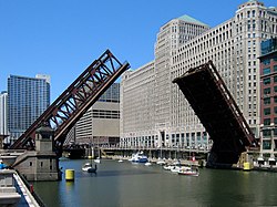
 The bridge carrying a Chicago Transit Authority Chicago 'L' train in 2009 | |
| Coordinates | 41°53′15″N87°38′02″W / 41.88750°N 87.63389°W |
| Carries | Automobiles Pedestrians |
| Crosses | Chicago River |
| Locale | Chicago, Cook County, Illinois |
| Official name | Wells Street Bridge |
| Characteristics | |
| Design | Double-deck, double-leaf bascule bridge |
| Total length | 231 feet [1] |
| Width | 72 feet [1] |
| Longest span | 268 feet [1] |
| Clearance above | 16 feet [1] |
| Rail characteristics | |
| No. of tracks | 2 |
| Track gauge | 4 ft 8+1⁄2 in (1,435 mm) standard gauge |
| Electrified | Third rail, 600 V DC |
| History | |
| Designer | E. H. Bennett |
| Opened | February 11, 1922 |
| Rebuilt | 2012-2013 |
| Location | |
 | |
The Wells Street Bridge is a bascule bridge over the Chicago River, in downtown Chicago, Illinois, United States, which was built in 1922. Standing east of the Franklin Street Bridge and southeast of the Merchandise Mart, the bridge connects the Near North Side with "The Loop". The bridge is double-decked, the lower deck carrying three lanes of traffic south over the river with sidewalks on both sides of the street. The upper deck serves as a bridge for the Chicago Transit Authority's Brown and Purple lines. Bridge tenders' houses for controlling the bridge are on the northwest and southeast corners of the bridge.