Cumberland station (CTA)

Last updated

Cumberland
 
8400W
5700N
Chicago 'L' rapid transit station
Cumberland CTA Station Exterior.jpg
The exterior of the station building at Cumberland
General information
Location5800 North Cumberland Avenue
Chicago, Illinois 60631
Coordinates 41°59′03″N87°50′17″W / 41.984246°N 87.838028°W / 41.984246; -87.838028
Owned by Chicago Transit Authority
Line(s) O'Hare Branch
Platforms1 Island platform
Tracks2
Connections CTA
Pace
Greyhound Buses
Burlington Trailways Buses
Construction
Structure typeExpressway median
Parking Aiga parking inv.svg 1633 spaces
Bicycle facilitiesYes
AccessibleYes
History
OpenedFebruary 27, 1983;41 years ago (1983-02-27)
Rebuilt2016
Passengers
2022488,142 [1] Increase2.svg 29.8%
Services
Preceding station Chicago "L" Following station
Rosemont
toward O'Hare Pictograms-nps-airport.svg
Blue Line Harlem
toward Forest Park
Location
Cumberland station (CTA)

Cumberland is a station on the Chicago Transit Authority's 'L' system. Situated on the Blue Line between Rosemont and Harlem, the station is located in the median of the Kennedy Expressway at Cumberland Avenue in the O'Hare community area on Chicago's Northwest Side. It is also in close proximity to both the Norwood Park neighborhood and the city of Park Ridge as well as the village of Norridge. The area surrounding the station consists of mixed commercial and residential development.

Contents

The Cumberland station was first proposed in 1972 as part of an extension of the Blue Line from Logan Square to O'Hare International Airport. The station opened on February 27, 1983, along with Harlem and River Road. The three new stations brought 6,000 new riders to the northwest CTA line in the following month, and Cumberland became especially attractive to suburban commuters. The station at Cumberland consists of a single island platform; a pedestrian overpass connects the platform to a station building to the south and an exit stairway to the north. The station also includes a bus terminal and a park and ride lot. Trains serve Cumberland 24 hours a day every day; the headway between trains is 2–7 minutes during peak periods, with less frequent service at other times. In addition to trains, Cumberland also serves CTA buses, Pace buses, Burlington Trailways buses, and Greyhound buses.

Location

Cumberland is located at the junction of Cumberland Avenue and the Kennedy Expressway (I-90, exit 79). The station is located on a border between O'Hare and Norwood Park. [2] [3] It is the closest 'L' station to the city of Park Ridge, which borders Chicago along Higgins Road north of the station. [4] The area surrounding the station consists of a mixture of planned development, commercial, and residential areas. [5] Citicorp Plaza, an office building which houses the headquarters of telecommunications provider U.S. Cellular, is located to the south of Cumberland at 8410 W. Bryn Mawr. [6] North of Cumberland at 8725 W. Higgins Rd. is the headquarters of mapmaker Rand McNally. [7] The Renaissance Chicago O'Hare Suites Hotel is also located near the station at 8500 W. Bryn Mawr. [8]

History

Panorama of the station interior. Cumberland Blue Line CTA.JPG
Panorama of the station interior.

The extension of the CTA line in the median of the Kennedy Expressway from Jefferson Park to O'Hare Airport, which included the construction of the Cumberland station, was first proposed by Mayor Richard J. Daley in 1972 by the Chicago Public Works Commission. The cost of this project was initially estimated at $80 million. [9] The Chicago Plan Commission approved the project on August 8, 1974; by this point, the estimated cost of the project had risen to $174 million. [10] The federal government approved the project and agreed to provide 80 percent of the funds for its construction in 1978, and construction on the 7.9-mile (12.7 km) extension began in March 1980. [11] [12] [13] The extension was originally planned to open in 1982; however, its opening was delayed after a series of incidents including two strikes by workers on the line. [13] [14] The section of the extension from Jefferson Park to River Road, including Cumberland, opened on February 27, 1983; the CTA ran free shuttle trains between the new stations at River Road, and Harlem, the day before their opening so riders could "get acquainted" with the new line. [15] The final cost of the extension was $198.9 million, with the Cumberland station costing approximately $10 million. [12] [13]

In the month following the opening of the three new stations, 6,000 additional commuters used the northwest service. [16] The Cumberland station became particularly attractive to suburban commuters from Des Plaines and Park Ridge; a study commissioned shortly after the station's opening found that only 12.4% of commuters parking in the Cumberland and Rosemont stations were Chicagoans. [17] The influx of suburban commuters to the new Blue Line stops led to a fall in ridership on the Chicago & Northwestern's Northwest Line, which traditionally served the northwest suburbs near the new stops. [17]

Facilities

Rock Bow in the Cumberland station building Rock Bow from base.jpg
Rock Bow in the Cumberland station building

The Cumberland station was designed by Wojciech M. Madeyski of the architectural firm Perkins and Will. [18] Cumberland's island platform is located in the median of the Kennedy Expressway to the west of Cumberland Avenue. It serves the Blue Line's two tracks; the northern track serves trains to O'Hare, while the southern track serves trains to Forest Park. Electronic signs on the platform offer real-time information about train arrivals and service alerts; Cumberland is one of four 'L' stations with these signs, which were installed in 2002 as part of a pilot program. [19] [ needs update ] A pedestrian overpass connects the platform to entrances on the north and south sides of the expressway. [15] The north side of the overpass leads to an exit stairway, while the south side leads to the main station building. The station building houses a public art sculpture, Rock Bow by Charles Ross; the sculpture consists of a 40 feet (12 m) high metal-cased prism set in a limestone base. [20] Cumberland's bus terminal and park and ride lot are also located south of the platform. [15] The park and ride lot has 1633 spaces and is operated by CPS Parking; the lot originally had 706 spaces and expanded to its current capacity in 1992. [21] [22] The facilities at Cumberland are handicapped accessible. [23]

Train Service

Platform at Cumberland, 2021 Platform at Cumberland, looking outbound.jpg
Platform at Cumberland, 2021

Cumberland is part of the CTA's Blue Line, which runs from O'Hare Airport to downtown Chicago and Forest Park. It is the third inbound station from O'Hare on the Blue Line and is situated between the Rosemont and Harlem stations. Blue Line trains serve Cumberland 24 hours a day every day; trains operate roughly every 7 to 10 minutes during rush hour and midday operation, with longer headways of up to 30 minutes at night. [24] [25] The station is approximately seven minutes from O'Hare, 31 minutes from Clark/Lake in the Loop, and 52 minutes from Forest Park. [25] [26] [27] [28] 1,304,280 passengers boarded at Cumberland in 2011. [29]

Bus connections

CTA

Pace

Greyhound [30]

Cumberland services several bus routes in addition to 'L' trains. One CTA bus route terminate at the station, the 81W West Lawrence; this route provides service to Cumberland Avenue, Lawrence Avenue, East River Road, and the Jefferson Park Transit Center. [23] [31] [32] Four Pace bus routes also terminate at Cumberland: the 240 Dee Road, the 241 Greenwood/Talcott, the 290 Touhy Avenue, and the 331 Cumberland/5th Avenue. [23] These routes connect to the Golf Mill Shopping Center, the Howard 'L' station, and the communities of Park Ridge, Niles and Brookfield. [33] [34] [35] [36] Intercity bus routes operated by Greyhound [37] and by Burlington Trailways [38] also make stops at this station.

Related Research Articles

<span class="mw-page-title-main">Chicago "L"</span> Rapid transit system in Chicago, Illinois, US

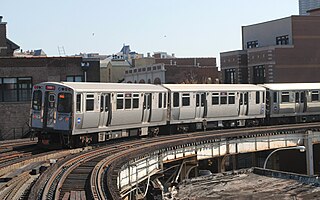
The Chicago "L" is the rapid transit system serving the city of Chicago and some of its surrounding suburbs in the U.S. state of Illinois. Operated by the Chicago Transit Authority (CTA), it is the fourth-largest rapid transit system in the United States in terms of total route length, at 102.8 miles (165.4 km) long as of 2014, and the third-busiest rapid transit system in the United States. In 2016, the "L" had 1,492 rail cars, eight different routes, and 145 train stations. In 2023, the system had 117,447,000 rides, or about 350,900 per weekday in the first quarter of 2024.

<span class="mw-page-title-main">Chicago Transit Authority</span> Transit agency in Chicago, Illinois

The Chicago Transit Authority (CTA) is the operator of mass transit in Chicago, Illinois, United States, and some of its suburbs, including the trains of the Chicago "L" and CTA bus service. In 2023, the system had a ridership of 279,146,200, or about 881,400 per weekday as of the first quarter of 2024.

<span class="mw-page-title-main">Red Line (CTA)</span> Rapid transit line in Chicago

The Red Line is a rapid transit line in Chicago, run by the Chicago Transit Authority (CTA) as part of the Chicago "L" system. It is the busiest line on the "L" system, with an average of 93,457 passengers boarding each weekday in 2022. The route is 26 miles (42 km) long with a total of 33 stations. It runs elevated from the Howard station in the Rogers Park neighborhood on the North Side, through a subway on the Near North Side, Downtown, and the South Loop, and then through the Dan Ryan Expressway median to 95th/Dan Ryan in the Roseland neighborhood on the South Side.

<span class="mw-page-title-main">Blue Line (CTA)</span> Rapid transit line in Chicago

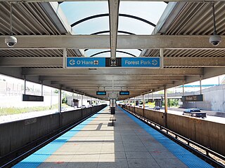
The Blue Line is a 26.93-mile-long (43.34 km) Chicago "L" line which extends through The Loop from O'Hare International Airport at the far northwest end of the city, through downtown via the Milwaukee–Dearborn subway and across the West Side to its southwest end at Forest Park, with a total of 33 stations. At about 27 miles, it is the longest line on the Chicago "L" system and second busiest, and one of the longest local subway/elevated lines in the world. It has an average of 64,978 passengers boarding each weekday in 2022.

<span class="mw-page-title-main">Pace (transit)</span> Suburban bus and paratransit service in the Chicago metropolitan area

Pace is the suburban bus and regional paratransit division of the Regional Transportation Authority serving the Chicago metropolitan area. It was created in 1983 by the RTA Act, which established the formula that provides funding to the CTA, Metra, and Pace. The various agencies providing bus service in the Chicago suburbs were merged under the Suburban Bus Division, which rebranded as Pace in 1984. In 2022, Pace had 18.041 million riders.

<span class="mw-page-title-main">95th/Dan Ryan station</span> Chicago "L" station

95th/Dan Ryan, announced as 95th, is an 'L' station in the median of the Dan Ryan Expressway and serving Chicago's Roseland neighborhood. It serves as the southern terminus of the Chicago Transit Authority's Red Line. This station was the system's thirteenth busiest in 2021. Trains take approximately 30 minutes to travel to the Loop, and 60 minutes to reach Howard.

<span class="mw-page-title-main">Dempster–Skokie station</span> Chicago "L" station

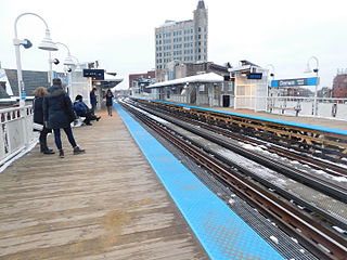
Dempster–Skokie, formerly known as Dempster, or Skokie, is an 'L' station on the CTA's Yellow Line at 5005 Dempster Street in Skokie, Illinois. It is one of three stops on the Yellow Line, and the line’s western terminus, Dempster–Skokie is one of two CTA rail stations in Skokie, and is at grade level.

<span class="mw-page-title-main">Austin station (CTA Green Line)</span> Chicago "L" station

Austin is a station on the Chicago Transit Authority's 'L' system. It is located between the Ridgeland and Central stations on the Green Line, which runs from Harlem/Lake and to Ashland/63rd and Cottage Grove. The station is located at the intersection of Austin Boulevard and Corcoran Place in the Austin neighborhood on Chicago's West Side and borders the village of Oak Park.

<span class="mw-page-title-main">Harlem/Lake station</span> Chicago "L" station

Harlem/Lake, announced as Harlem, is a station on the Chicago Transit Authority's 'L' system, serving the Green Line. It is the northwestern terminus of the Green Line.

<span class="mw-page-title-main">O'Hare station</span> Chicago "L" station

O'Hare is a Chicago "L" station located at O'Hare International Airport, 17 miles (27 km) northwest of The Loop. The northwestern terminus of the Chicago Transit Authority's Blue Line, it is a subway station with two island platforms serving three tracks, situated under the parking garage for Terminals 1, 2, and 3. Trains are scheduled to depart from O'Hare every 2–7 minutes during rush-hour periods and take about 40 minutes to travel to the Loop. It is the westernmost station of the Chicago 'L' system. It is also the only station without coordinates in Chicago's grid system, the only underground terminus, and is the only terminal that does not directly connect to any CTA or Pace buses. It is also one of two terminals that does not have a yard assigned to it.

<span class="mw-page-title-main">Pulaski station (CTA Orange Line)</span> Chicago "L" station

Pulaski is an 'L' station on the CTA's Orange Line, which runs between Midway Airport and The Loop; it is situated between Midway and Kedzie stations. Pulaski is located at Pulaski Road and 51st Street on the Southwest Side of Chicago, Illinois. The station is within the Archer Heights neighborhood, which is both residential and commercial, and the station itself is in a commercial district on Pulaski Road. Pulaski opened on October 31, 1993, the opening date of the Orange Line.

<span class="mw-page-title-main">Rosemont station (CTA)</span> Chicago "L" station

Rosemont, formerly River Road, is a Chicago "L" station at the intersection of River Road and I-190 in the suburb of Rosemont, Illinois. It is located in the median of I-190 with one island platform serving two tracks, 16 miles (26 km) northwest of The Loop. Trains are scheduled to depart from Rosemont every 2–7 minutes during rush-hour periods, and take about 36 minutes to travel to the Loop. The station is 7 blocks east and 2 blocks north of O'Hare International Airport. Rosemont is the busiest station outside the city limits of Chicago, with 2,090,977 passenger entries in 2014.

<span class="mw-page-title-main">Harlem station (CTA Blue Line O'Hare branch)</span> Chicago "L" station

Harlem is a Chicago "L" station serving the Blue Line's O'Hare branch in Chicago's Norwood Park neighborhood. It is not to be confused with the other Harlem Blue Line station. Trains run from Harlem every 2–7 minutes during rush hour, and take 30–45 minutes to travel to the Loop. O'Hare-bound trains take 10 minutes to reach the airport from Harlem. The station is located in the median of the Kennedy Expressway.

<span class="mw-page-title-main">Addison station (CTA Blue Line)</span> Chicago "L" station

Addison is a station on the Chicago Transit Authority's 'L' system, serving the Blue Line. It is also the only station whose coordinates are equal. It is the first station in the median of the Kennedy Expressway located between the Avondale neighborhood and Irving Park neighborhood. The Villa District is accessible by this station.

<span class="mw-page-title-main">Logan Square station</span> Chicago "L" station

Logan Square is a subway station on the Chicago Transit Authority's 'L' system, serving the Blue Line and the Logan Square neighborhood. It was the terminus of the Milwaukee Elevated until it was extended to Jefferson Park in 1970 via the Kennedy Expressway. From Logan Square, trains run at intervals of 2–7 minutes during rush-hour periods, and take 14 minutes to travel to the Loop. O'Hare bound trains take 26 minutes to reach the airport.

<span class="mw-page-title-main">Damen station (CTA Blue Line)</span> Rapid transit station in Chicago

Damen is a rapid transit station on the Chicago "L", currently serving the O'Hare branch of its Blue Line. Opened on May 6, 1895, as Robey, it is the oldest station on the Blue Line. The station serves the popular Bucktown and Wicker Park neighborhoods, and is consistently in the top 40 highest-ridership "L" stations. It has two wooden side platforms and a brick station house at street level. The west platform, serving southbound trains, contains a tower that has never been used but is a relic of the station's past. The station is served by three bus routes on Damen, Milwaukee, and North Avenues, which are each descended from streetcar lines on those streets in the early 20th century. The Blue Line has owl service; while the surrounding streetcar lines also had owl service in the early 20th century, the modern bus services do not.

<span class="mw-page-title-main">Harlem station (CTA Blue Line Forest Park branch)</span> Chicago "L" station

Harlem is a station on the 'L' system, serving the Blue Line's Forest Park branch in Forest Park, Illinois. The station was built with an auxiliary entrance at Circle Avenue that was eventually converted to an single turnstile facility. The Circle Avenue entrance reopened as an auxiliary entrance/exit on September 26, 2009, at 4 PM. To the south of the station is the Ferrara Candy Company A Roos chest-making factory was located west of the station and Circle Avenue until it was torn down in 2013 to make way for a new recreation park that opened there in 2018. The Roos company closed for good in 1951.

<span class="mw-page-title-main">Forest Park station</span> Rapid transit station in Chicago

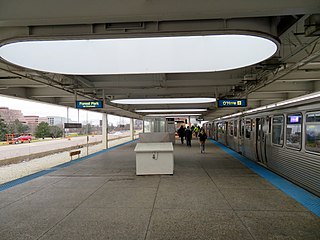
Forest Park is a station on the Chicago Transit Authority's 'L' system, located in the village of Forest Park, Illinois and serving the Blue Line. Before the Congress Line was built, it served as terminal for the Garfield Line. It is the western terminus of the Forest Park branch. The station was known as Des Plaines until 1994. It is also referred to as the Forest Park Transit Center by Pace because it is a major terminal for Pace buses. The station contains a 1,051-space Park and Ride lot which uses the "Pay and Display" system, in which fees are paid at the lot entrance. It is located south of the Baltimore and Ohio Chicago Terminal Railroad tracks which curve to the north of the station towards Madison Street where the line rechristens itself to the Canadian National Railway's Waukesha Subdivision.

<span class="mw-page-title-main">Jefferson Park Transit Center</span> Transport hub in Chicago, Illinois

The Jefferson Park Transit Center is an intermodal passenger transport hub in the Jefferson Park neighborhood of Chicago, Illinois. It serves as a station for rail and also as a bus terminal. Jefferson Park Transit Center's railroad station is on Metra's Union Pacific Northwest Line, with the station located at 4963 North Milwaukee Avenue. Jefferson Park is 9.1 miles (14.6 km) away from Ogilvie Transportation Center in downtown Chicago, the inbound terminus of the Union Pacific Northwest Line. Under Metra's zone-based fare system, Jefferson Park is in zone 2. As of 2018, Jefferson Park is the 97th busiest of Metra's 236 non-downtown stations, with an average of 510 weekday boardings.

<span class="mw-page-title-main">Transportation in Chicago</span> Overview of transportation in the city of Chicago, Illinois

Chicago, Illinois, is the third-largest city in the United States and a world transit hub. The area is served by two major airports, numerous highways, elevated/subway local train lines, and city/suburban commuter rail lines; it is the national passenger rail hub for Amtrak routes, and also the main freight rail hub of North America.

References

  1. "Annual Ridership Report Calendar Year 2022" (PDF). Chicago Transit Authority, Ridership Analysis and Reporting. February 2, 2023. Retrieved June 10, 2023.
  2. "O'Hare Community Area Map" (PDF). City of Chicago. June 2010. Retrieved July 2, 2010.
  3. "Norwood Park Community Area Map" (PDF). City of Chicago. June 2010. Retrieved July 2, 2010.
  4. "City of Park Ridge Street Map" (PDF). City of Park Ridge. March 2010. Retrieved July 2, 2010.
  5. City of Chicago Zoning Map (Map). Chicago Department of Zoning. 2010.
  6. Eddie Baeb (April 23, 2008). "U.S. Cellular to explore HQ move". Crain's Chicago Business .
  7. "Contact Us". randpublishing.com. Retrieved 2024-06-25.
  8. "Renaissance Chicago O'Hare Suites Hotel". Renaissance Hotels . Retrieved July 2, 2010.
  9. Schreiber, Edward (December 15, 1972). "City Urged to Extend CTA 'L' Along Kennedy to O'Hare". Chicago Tribune . p. 10.
  10. Gilbert, David (August 12, 1974). "Foes ask review of O'Hare link". Chicago Tribune . p. 1.
  11. Coffey, Raymond; David Young (June 6, 1978). "Transit plan, O'Hare link get federal OK". Chicago Tribune . p. 1.
  12. 1 2 "CTA Celebrates 20 Years of Service to O'Hare Airport". Chicago Transit Authority . Retrieved July 1, 2010.
  13. 1 2 3 Young, David (February 13, 1981). "Chicago 'L' line to O'Hare in 1982". Chicago Tribune .
  14. Young, David (June 22, 1982). "Sidetracked transit". Chicago Tribune . p. D12.
  15. 1 2 3 Young, David; John C. White (February 27, 1983). "First Link of O'Hare Line Opens". Chicago Tribune . p. 1. Retrieved March 22, 2018 via Newspapers.com. Open Access logo PLoS transparent.svg
  16. Young, David (April 6, 1983). "CTA picks up 6,000 more commuters". Chicago Tribune .
  17. 1 2 Young, David (June 1, 1983). "O'Hare extension draining C&NW ridership". Chicago Tribune .
  18. Paul Gapp (March 24, 1985). "From schools to Big Stan, local firm has had a fine 50 years". Chicago Tribune .
  19. Garfield, Graham. "Cumberland". Chicago-'L'.org. Retrieved July 1, 2010.
  20. M. W. Newman (March 8, 1987). "City-sponsored artists are puttin' on the glitz". Chicago Sun-Times .
  21. "Park and Ride Locations at 'L' Stations: Blue Line". Chicago Transit Authority . Retrieved July 2, 2010.
  22. Gillis, Michael (January 9, 1992). "CTA to add parking during Kennedy Expy. work". Chicago Sun-Times .
  23. 1 2 3 "Cumberland Station Information". Chicago Transit Authority . Retrieved July 1, 2010.
  24. "Blue Line Route Guide". Chicago Transit Authority . Retrieved July 1, 2010.
  25. 1 2 "Cumberland Station Timetable" (PDF). Chicago Transit Authority. Archived from the original (PDF) on July 10, 2010. Retrieved July 1, 2010.
  26. "O'Hare Station Timetable" (PDF). Chicago Transit Authority. Archived from the original (PDF) on July 26, 2010. Retrieved July 1, 2010.
  27. "Clark/Lake Station Timetable" (PDF). Chicago Transit Authority. Archived from the original (PDF) on July 26, 2010. Retrieved July 1, 2010.
  28. "Forest Park Station Timetable" (PDF). Chicago Transit Authority. Archived from the original (PDF) on July 26, 2010. Retrieved July 1, 2010.
  29. "Annual Ridership Report: Calendar Year 2011" (PDF). Chicago Transit Authority . Retrieved February 16, 2012.
  30. http://www.greyhound.com/en/locations/terminal.aspx?city=561407 Chicago Cumberland Greyhound Terminal
  31. "#69 Cumberland/East River Bus Route Information" . Retrieved July 1, 2010.
  32. "#81W West Laurence". Chicago Transit Authority . Retrieved July 1, 2010.
  33. "Route 240 - Dee Road". Pace. Archived from the original on August 31, 2010. Retrieved July 1, 2010.
  34. "Route 241 - Greenwood-Talcott". Pace. Archived from the original on July 12, 2010. Retrieved July 1, 2010.
  35. "Route 290 - Touhy Avenue". Pace. Archived from the original on May 29, 2010. Retrieved July 1, 2010.
  36. "Route 331 - Cumberland-5th Avenue". Pace. Archived from the original on August 26, 2010. Retrieved July 1, 2010.
  37. "Greyhound.com: Locations: Chicago (Cumberland), Illinois". Greyhound. Retrieved July 1, 2010.
  38. "burlingtontrailways.com: Routes and Maps". Burlington Trailways. Archived from the original on January 16, 2013. Retrieved February 9, 2013.