
The polar bear is a hypercarnivorous bear whose native range lies largely within the Arctic Circle, encompassing the Arctic Ocean, its surrounding seas and surrounding land masses. It is the largest extant bear species, as well as the largest extant land carnivore. A boar weighs around 350–700 kg (770–1,540 lb), while a sow is about half that size. Although it is the sister species of the brown bear, it has evolved to occupy a narrower ecological niche, with many body characteristics adapted for cold temperatures, for moving across snow, ice and open water, and for hunting seals, which make up most of its diet. Although most polar bears are born on land, they spend most of their time on the sea ice. Their scientific name means "maritime bear" and derives from this fact. Polar bears hunt their preferred food of seals from the edge of sea ice, often living off fat reserves when no sea ice is present. Because of their dependence on the sea ice, polar bears are classified as marine mammals.

The Arctic National Wildlife Refuge is a national wildlife refuge in northeastern Alaska, United States. It consists of 19,286,722 acres (78,050.59 km2) in the Alaska North Slope region. It is the largest national wildlife refuge in the country, slightly larger than the Yukon Delta National Wildlife Refuge. The refuge is administered from offices in Fairbanks. ANWR includes a large variety of species of plants and animals, such as polar bears, grizzly bears, black bears, moose, caribou, wolves, eagles, lynx, wolverine, marten, beaver and migratory birds, which rely on the refuge.

The king eider is a large sea duck that breeds along Northern Hemisphere Arctic coasts of northeast Europe, North America and Asia. The birds spend most of the year in coastal marine ecosystems at high latitudes, and migrate to Arctic tundra to breed in June and July. They lay four to seven eggs in a scrape on the ground lined with grass and down.

The Alaska Peninsula National Wildlife Refuge is a United States National Wildlife Refuge in southwestern Alaska whose use is regulated as an ecological-protection measure. It stretches along the southern coast of the Alaska Peninsula, between the Becharof National Wildlife Refuge on its east and the end of the peninsula at False Pass in the west. In between, however, it is broken into sections by lands of the Aniakchak National Monument and Izembek National Wildlife Refuge. The refuge is administered from offices in King Salmon, Alaska and was established to conserve Alaska Peninsula brown bears, caribou, moose, marine mammals, shorebirds, other migratory birds and fish, and to comply with treaty obligations.
The Colville River is a major river of the Arctic Ocean coast of Alaska in the United States, approximately 350 miles (560 km) long. One of the northernmost major rivers in North America, it drains a remote area of tundra on the north side of the Brooks Range entirely above the Arctic Circle. The river is frozen for more than half the year and floods each spring.

Teshekpuk Lake is a 22 miles (35 km) wide lake on the Arctic coast of the U.S. state of Alaska, South of Pitt Point, 12 miles (19 km) east of Harrison Bay, 80 miles (130 km) east of Point Barrow.
The Nushagak Peninsula is an uninhabited peninsula in the U.S. state of Alaska. It is situated in the Dillingham Census Area, west of the Alaska Peninsula. The 520,000 acres (210,000 ha) byland measures 35 by 15 miles. It was named for Nushagak Bay in 1910 by the U.S. Coast and Geodetic Survey. With a large area of lakes, ponds and tidal sloughs, the peninsula contains the biggest complex of wetlands of the Togiak National Wildlife Refuge.

The Yukon Delta National Wildlife Refuge is a United States National Wildlife Refuge covering about 19.16 million acres (77,500 km2) in southwestern Alaska. It is the second-largest National Wildlife Refuge in the country, only slightly smaller than the Arctic National Wildlife Refuge. It is a coastal plain extending to the Bering Sea, covering the delta created by the Yukon and Kuskokwim rivers. The delta includes extensive wetlands near sea level that are often inundated by Bering Sea tides. It is bordered on the east by Wood-Tikchik State Park, the largest state park in the United States. The refuge is administered from offices in Bethel.

The Anaktuvuk River is a river in Alaska's North Slope. One hundred and thirty-five miles (217 km) long, it flows west from glaciers in the Endicott Mountains changing direction just north of Anaktuvuk Pass to flow north to the Arctic Coastal Plain where it joins the Colville River. Its headwaters are formed by runoff from various glaciers in the Gates of the Arctic Wilderness on the slopes of Fan Mountain, Alapah Mountain and Limestack Mountain, the last of which lies on the watershed divide between the Arctic Coastal Plain and the Koyukuk River, and feeds the Anaktuvuk River via Graylime Creek. Its first major tributary is the John River which joins it at 68°12′14″N151°36′50″W. The Nanushuk River joins it at 69°18′11″N150°59′58″W.

The National Petroleum Reserve in Alaska (NPRA) is an area of land on the Alaska North Slope owned by the United States federal government and managed by the Department of the Interior, Bureau of Land Management (BLM). It lies to the west of the Arctic National Wildlife Refuge, which, as a U.S. Fish and Wildlife Service managed National Wildlife Refuge, is also federal land.
The wildlife of Alaska is both diverse and abundant. The Alaskan Peninsula provides an important habitat for fish, mammals, reptiles, and birds. At the top of the food chain are the bears. Alaska contains about 70% of the total North American brown bear population and the majority of the grizzly bears. as well as black bears and Kodiak bears. In winter, polar bears can be found in the Kuskokwim Delta, St. Matthew Island, and at the southernmost portion of St. Lawrence Island.There are also moose and caribou, bison, wolves and wolverines, foxes, otters and beavers. Fish species are extensive, including: salmon, graylings, char, rainbow and lake trout, northern pike, halibut, pollock, and burbot. The bird population consists of hundreds of species, including: bald eagles, owls, falcons, ravens, ducks, geese, swans, and the passerines. Sea lions, seals, sea otters, and migratory whales are often found close to shore and in offshore waters. The Alaskan waters are home to two species of turtles, the leatherback sea turtle and the green sea turtle. Alaska has two species of frogs, the Columbia spotted frog and wood frog, plus two introduced species, the Pacific tree frog and the red-legged frog. The only species of toad in Alaska is the western toad. There are over 3,000 recorded species of marine macroinvertebrates inhabiting the marine waters, the most common being the various species of shrimp, crab, lobster, and sponge.
The Chukchi Sea Shelf or Chukchi Shelf is the westernmost part of the continental shelf of the United States and the easternmost part of the continental shelf of Russia. Within this shelf, the 50-mile Chukchi Corridor acts as a passageway for one of the largest marine mammal migrations in the world.
The Hudson Plains Ecozone, as defined by the Commission for Environmental Cooperation (CEC), is a sparsely populated Canadian subarctic ecozone extending from the western coast of Quebec to the coast of Manitoba, encompassing all coastal areas of James Bay and those of southern Hudson Bay, stretching to about 50°N latitude. It includes the largest continuous wetland in the world. It covers nearly a quarter of Ontario's landmass, and 3.6% of Canada's total area, totalling approximately 369,000 square kilometres of land and 11,800 square kilometres of water. Its historical prominence is due to the harshness endured by pioneer explorers who established fortifications for Hudson's Bay Company, and as a result of regional wars between France and Britain. Today, it is primarily noted for the well-known Polar Bear Provincial Park, and to a lesser extent Wapusk National Park, as well as its vast wetlands which are used by migratory birds.
The Kendall Island Migratory Bird Sanctuary (KIBS) is a migratory bird sanctuary in the Northwest Territories, Canada. It is located on Kendall Island and its surrounding area in Mackenzie Bay at the northern tip of the Mackenzie River Delta. A seasonal sanctuary for more than 60,000 shorebirds. it is one of five bird sanctuaries within the Inuvialuit Settlement Region. The area that is now known as the KIBS is a traditional Inuvialuit whaling site.
Cape Parry is a headland in Canada's Northwest Territories. Located at the northern tip of the Parry Peninsula, it projects into Amundsen Gulf. The nearest settlement is Paulatuk, 100 km (62 mi) to the south, and Fiji Island is located 9 km (5.6 mi) to the west. Cape Parry was formerly accessible through Cape Parry Airport that was located at the Distant Early Warning Line. The airport was listed as abandoned after the closure of the DEW line site.
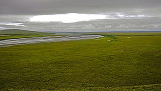
The Arctic coastal tundra is an ecoregion of the far north of North America, an important breeding ground for a great deal of wildlife.
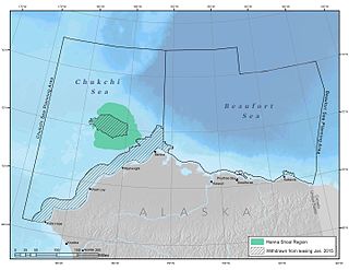
Hanna Shoal is a shallow, natural shoal located off the coast of northwest Alaska in the Chukchi Sea. The region around Hanna Shoal is one of the Chukchi Sea’s most biologically productive areas.
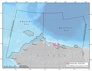
Colville Delta is a river delta in northern Alaska that flows into Harrison Bay. The delta is so flat that it has been said that it is indiscernible where the river ends and the ocean begins. The powerful outflow of the Colville River creates a shallow region that is rich with nutrients, making it ecologically significant for wildlife.

Barrow Canyon is a submarine canyon that straddles the boundary between the Beaufort and Chukchi seas. Compared to other nearby areas and the Canada Basin, the highly productive Barrow Canyon supports a diversity of marine animals and invertebrates.

Smith Bay is an estuary in the Beaufort Sea that supports a wide range of fish, birds, and marine mammals. It is located northeast of Point Barrow, Alaska. The Bureau of Ocean Energy Management recognizes the southeastern portion of Barrow Canyon, which covers some, but not all, of Smith Bay, as an Environmentally Important Area.
