Haut-Martelange

Last updated
Haut-Martelange
Uewermaartel
Martelange-Haut, Musee de l'ardoise (3).jpg
Disused railway station
Country Flag of Luxembourg.svg  Luxembourg
Canton Redange
Commune Rambrouch
Population
  Total23
Time zone UTC+1 (CET)
  Summer (DST) UTC+2 (CEST)

Haut-Martelange (Luxembourgish: Uewermaartel) is a village in northwestern Luxembourg. [1]

Contents

It is situated in the commune of Rambrouch, right along the border with Belgium.

It has a population of 19 as of 2024. [2]

Slate industry

During the 19th century, mines in Haut-Martelange were one of the main exporters of slate in Europe.

The village of Haut-Martelange formed around underground slate mines, which were established towards the end of the 17th century in the valley Haut-Martelange is located in.

The importance of the site grew significantly after investments were made by the Rother family from Frankfurt. The connection of Haut-Martelange to the Noerdange-Martelange railway line (Jhangeli) in 1890 gave the possibility for high-volume exports to the whole of Europe.

During this time, the slate mines of Haut-Martelange accounted for a significant amount of Luxembourg's exports and were a major provider of labour in the region. The underground mines grew to become among the most important in Europe.

The extraction of slate stopped in 1986 after the death of Christiane Rother in 1985, the last descendant of the Rother family.

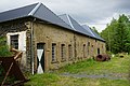
Today, a museum has been established in the disused slate facilities. [3]

Related Research Articles

<span class="mw-page-title-main">Luxembourg</span> Country in Western Europe

Luxembourg, officially the Grand Duchy of Luxembourg, is a small landlocked country in Western Europe. It is bordered by Belgium to the west and north, Germany to the east, and France to the south. Its capital and most populous city, Luxembourg, is one of the four institutional seats of the European Union and the seat of several EU institutions, notably the Court of Justice of the European Union, the highest judicial authority. Luxembourg's culture, people, and languages are highly intertwined with its French and German neighbors; while Luxembourgish is the only national language of the Luxembourgish people and of the Grand Duchy of Luxembourg, French is the only language for legislation, and all three – Luxembourgish, French and German – are used for administrative matters in the country.

<span class="mw-page-title-main">Aubange</span> City and municipality in French Community, Belgium

Aubange is a city and municipality of Wallonia located in the province of Luxembourg, Belgium.

<span class="mw-page-title-main">Martelange</span> Municipality in French Community, Belgium

Martelange is a municipality of Wallonia located in the province of Luxembourg, Belgium.

<span class="mw-page-title-main">Messancy</span> Municipality in French Community, Belgium

Messancy is a municipality of Wallonia located in the province of Luxembourg, Belgium.

<span class="mw-page-title-main">Esch-sur-Alzette</span> City and commune in Luxembourg

Esch-sur-Alzette is a city in the Grand Duchy of Luxembourg and the country's second-most populous commune, with a population of 36,625 inhabitants, as of 2023. It lies in the south-west of the country, on the border with France and in the valley of the Alzette, which flows through the city. The city is usually referred to as just Esch; however, the full name distinguishes it from the village and commune of Esch-sur-Sûre which lies 45 kilometres further north. The country's capital, Luxembourg City, is roughly 15 km (9.3 mi) to the north-east. Esch was selected as the European Capital of Culture for 2022, alongside Kaunas and Novi Sad.

<span class="mw-page-title-main">Canton of Redange</span> Canton in Nord, Luxembourg

Redange is a canton in the northwest of Luxembourg. The capital is Redange, otherwise known as Redange-sur-Attert. It borders the cantons of Wiltz to the north, Diekirch and Mersch to the east, Capellen to the south and Belgium to the west.

<span class="mw-page-title-main">Pétange</span> Commune in Esch-sur-Alzette, Luxembourg

Pétange is a commune and town in south-western Luxembourg. It is part of the canton of Esch-sur-Alzette and is the fifth-most populous commune in Luxembourg, as well as the most populous without town status. Pétange lies at the borders with both Belgium and France.

<span class="mw-page-title-main">Oberpallen</span> Former commune of Luxembourg in Diekirch

Oberpallen is a small town in the commune of Beckerich, in western Luxembourg. In 2024, the town had a population of 437.

<span class="mw-page-title-main">Nagem</span> Village in Redange, Luxembourg

Nagem is a village in northwestern Luxembourg.

Merscheid is a village in northeastern Luxembourg.

<span class="mw-page-title-main">Seltz (Tandel)</span> Village in Luxembourg

Seltz is a village in northeastern Luxembourg.

<span class="mw-page-title-main">Brattert</span> Village in Luxembourg

Brattert is a village in northwestern Luxembourg.

<span class="mw-page-title-main">Ehner</span> Village in Luxembourg

Ehner is a village in northwestern Luxembourg.

<span class="mw-page-title-main">Eltz (Redange)</span> Village in Luxembourg

Eltz is a village in northwestern Luxembourg.

<span class="mw-page-title-main">Flatzbour</span> Village in Luxembourg

Flatzbour is a village in northwestern Luxembourg.

Heispelt is a village in northwestern Luxembourg.

<span class="mw-page-title-main">Huttange</span> Village in Luxembourg

Huttange is a village in northwestern Luxembourg.

<span class="mw-page-title-main">Kuborn</span> Village in Luxembourg

Kuborn is a village in northwestern Luxembourg.

<span class="mw-page-title-main">Petit-Nobressard</span> Village in Luxembourg

Petit-Nobressard is a village in northwestern Luxembourg.

<span class="mw-page-title-main">Schwebach</span> Village in Luxembourg

Schwebach is a village in northwestern Luxembourg.

References

  1. "Geoportail". map.geoportail.lu. Retrieved 2022-05-24.
  2. "Registre national des personnes physiques RNPP : Population par localité". data.public.lu. 2024-01-07.
  3. "HISTORY". Musée de l'Ardoise. Retrieved 2022-05-24.

49°49′28″N5°44′59″E / 49.82444°N 5.74972°E / 49.82444; 5.74972