Rambrouch Rammerech, Rammerich | |
|---|---|
 | |
 Coat of arms | |
 Map of Luxembourg with Rambrouch highlighted in orange, and the canton in dark red | |
| Coordinates: 49°49′48″N5°50′59″E / 49.829875°N 5.849781°E | |
| Country | |
| Canton | Redange |
| Government | |
| • Mayor | Myriam Binck |
| Area | |
• Total | 79.09 km2 (30.54 sq mi) |
| • Rank | 3rd of 100 |
| Highest elevation | 554 m (1,818 ft) |
| • Rank | 2nd of 100 |
| Lowest elevation | 311 m (1,020 ft) |
| • Rank | 97th of 100 |
| Population (2025) | |
• Total | 5,004 |
| • Rank | 37th of 100 |
| • Density | 63/km2 (160/sq mi) |
| • Rank | 98th of 100 |
| Time zone | UTC+1 (CET) |
| • Summer (DST) | UTC+2 (CEST) |
| LAU 2 | LU0000704 |
| Website | rambrouch.lu |
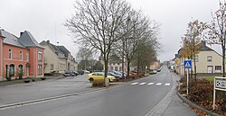
Rambrouch (Luxembourgish : Rammerech or (locally) Rammerich; German : Rambruch) is a commune and small town in western Luxembourg, in the canton of Redange. It lies close to the border with Belgium.
Contents
Rambrouch was formed on 1 January 1979 from the former communes of Arsdorf, Bigonville, Folschette, and Perlé, all in Redange canton. The law creating Rambrouch was passed on 27 July 1978. [1]
As of 2024 [update] , the town of Rambrouch, which lies in the centre of the commune, has a population of 572. [2]
