Canton of Redange Kanton Réiden | |
---|---|
Coordinates: 49°48′N5°48′E / 49.800°N 5.800°E | |
Country | Luxembourg |
Legislative constituency | Nord |
LAU 1 | LU00003 |
Communes (cities in bold) | Beckerich Ell Groussbus-Wal Préizerdaul Rambrouch Redange Saeul Useldange Vichten |
Area | |
• Total | 267.5 km2 (103.3 sq mi) |
• Rank | 2nd of 12 |
Highest elevation | 554 m (1,818 ft) |
Lowest elevation | 232 m (761 ft) |
Population (2023) | |
• Total | 20,874 |
• Rank | 9th of 12 |
• Density | 78/km2 (200/sq mi) |
• Rank | 9th of 12 |
Redange is a canton in the northwest of Luxembourg. Its namesake commune is Redange, officially known as Redange-sur-Attert. It borders the cantons of Wiltz to the north, Diekirch and Mersch to the east, Capellen to the south and Belgium to the west (Province de Luxembourg).
The canton lies right on the border of the two main landscapes of Luxembourg.
To the north, the landscape is dominated by the Oesling mountain range, which is a part of the greater Ardennes region. This region is characterised by densely forested hills with an average altitude of 400 to 500m above sealevel, with the highest point being Napoléonsgaard standing at 554m.
Furthermore this region shows deep valleys which were carved into the ground by rivers and streams, the Sauer and Wark being the most notable ones. The upper Sûre lake reservoir also lies partly within the Canton of Redange, at the border with the Canton of Wiltz.
The Oesling part of the Canton mainly comprises the communes of Rambrouch and Groussbus-Wal with the communes of Ell, Redange and Préitzerdaul partly being situated in the Oesling region.
To the south, the landscape is dominated by the Gutland plain. This area is characterised by lower altitudes, averaging at around 300m above sealevel.
Wide shallow river valleys dominate the landscape with less forest coverage than in the north. The most important river in this region is the Attert.
The communes lying in the Gutland part of the Canton are Beckerich, Saeul, Useldange, and Vichten. [1] [2]
The canton of Redange has a rural character. The only major town with more than 1'000 inhabitants is Redange-sur-Attert, the capital of the canton. Most infrastructure is therefore concentrated around the capital. Here a secondary school, supermarkets and a retirement home can be found.
Furthermore, there is a high concentration of gas stations linked to fuel tourism along the border with Belgium, in towns such as Haut-Martelange and Oberpallen.
The canton of Redange is not connected to the national Railway network.
By road, the canton of Redange is linked to various routes nationales, for example the N12 between Luxembourg City and Wiltz, or between Arlon (B) and Ettelbruck. Furthermore, the canton is covered by an extensive public bus network, which is a part of the Régime général des transports routiers (RGTR).
Redange Canton consists of the following nine communes:
Beckerich | Groussbus-Wal | Rambrouch | Saeul | Vichten |
Ell | Préitzerdaul | Redange | Useldange |
Human civilizations have settled in the canton of Redange since antiquity.
The most important archeological discovery in the canton of Redange from the gallo-roman period is a 10.36 × 5.92m mosaic that was discovered in 1994 in Vichten, in the east of the canton.
The mosaic was part of the floor in the entrance hall of a villa rustica and depicts the nine muses alongside the greek poet Homer. It was most likely created around 240 AD. [5]
Furthermore, numerous other archaeological sites can be fount throughout the canton, for example in Rippweiler, Hovelange and Schandel, among others. [6]
During the middle ages, the territory of the canton of Redange was part of the Duchy of Luxembourg, and was ruled by numerous lords and counts, who resided in castles dotted all around the canton. Even today, many ruins of castles can be found across the canton, the most notable one being Useldange castle.
During the French revolution, the Duchy of Luxembourg was incorporated into the French Republic as part of the Département des Forêts . Following multiple territorial reforms, communes were established, and in October 1796 the Département des Forêts was divided into 26 cantons. Among those the canton of Ospern, with most borders identical to the present-day canton of Redange (except the present-day eastern border with Belgium, which was established in 1839 following the 3rd partition of Luxembourg).
On 12 October 1841, the capital of the canton was ordered to be transferred from Ospern to Redange. [7]
Towards the end of the 17th century, slate mines were excavated near present-day Haut-Martelange and Rombach, in the northwest of the canton.
The importance of this site grew significantly after investments were made by the Rother family from Frankfurt. The connection of Haut-Martelange to the Noerdange-Martelange railway line (Jhangeli) in 1890 provided the possibility for high-volume exports across the whole of Europe.
During this time, the slate mines of Haut-Martelange accounted for a significant amount of Luxembourg's exports and were a major provider of labour in the region. The underground mines grew to become among the most important producers of slate in Europe.
The extraction of slate stopped in 1986 after the death of Christiane Rother in 1985, the last descendant of the Rother family. [8]
Graphs are unavailable due to technical issues. There is more info on Phabricator and on MediaWiki.org. |
The three districts of Luxembourg were the top-level administrative divisions of the Grand Duchy of Luxembourg. The districts were further subdivided into cantons, which still exist:
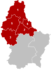
The District of Diekirch was one of three districts of the Grand Duchy of Luxembourg. Immediately prior to its abolition on 3 October 2015, it contained five cantons divided into 43 communes:
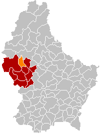
The 12 cantons of the Grand Duchy of Luxembourg are subdivisions at the first level of local administrative unit (LAU-1) in the European Union's Nomenclature of Territorial Units for Statistics for Eurostat purposes. They were subdivisions of the three districts of Luxembourg until 2015, when the district level of government was abolished. The cantons are in turn subdivided into 100 communes.
Redange or Redange-sur-Attert is a commune and town in northwestern Luxembourg, near the border with Belgium. It is situated in the eponymous canton of Redange. Redange is situated on the river Attert, a tributary of the Alzette.
Wahl is a former commune and small village in western Luxembourg, in the canton of Redange.
Ell is a commune and small town in western Luxembourg, in the canton of Redange. It lies close to the border with Belgium.
Luxembourg's 100 communes conform to LAU Level 2 and are the country's lowest administrative divisions.
Beckerich is a commune and small town in western Luxembourg, in the canton of Redange. It lies close to the border with Belgium.
Grosbous is a former commune and small town in northwestern Luxembourg, in the canton of Redange.
Rambrouch is a commune and small town in western Luxembourg, in the canton of Redange. It lies close to the border with Belgium.
Useldange is a commune and small town in western Luxembourg, in the canton of Redange.
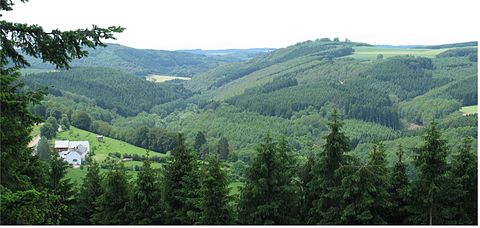
The Éislek, also known by its German name Ösling or Oesling, is a region covering the northern part of both the Grand Duchy of Luxembourg and Eifelkreis Bitburg-Prüm, within the greater Ardennes area that also covers parts of Belgium and France. The Éislek covers 32% of the territory of Luxembourg; to the south of the Éislek lies the Gutland, which covers the remaining 68% of the Grand Duchy as well as the southern part of the Eifelkreis Bitburg-Prüm.
The Guttland is a region covering the southern and central parts of the Grand Duchy of Luxembourg. The Guttland covers 68% of the territory of Luxembourg; to the north of Gutland lies the Éislek, which covers the remaining 32% of the Grand Duchy. To the east, the Luxembourgish Guttland adjoins the Bitburger Gutland of Germany.
Oberpallen is a small town in the commune of Beckerich, in western Luxembourg. In 2024, the town had a population of 437.
Folschette is a small town in the commune of Rambrouch, in western Luxembourg. As of 2024, the town has a population of 490.
Perlé is a small town in the commune of Rambrouch, in western Luxembourg. As of 2024, the town has a population of 912.
The district of Mersch was one of the four districts of Luxembourg between 1857 and 1867. It took its name from its administrative centre, the town of Mersch, and contained the cantons of Mersch and Redange. It is the only district to have been created after the initial establishment, and was the only district to have been abolished before they all were in 2015.
Eschette is a village in the commune of Rambrouch and the canton of Redange in western Luxembourg. As of 2024, it has 32 inhabitants.
Eltz is a village in northwestern Luxembourg.
Haut-Martelange is a village in northwestern Luxembourg.