Bous-Waldbredimus

Last updated
Bous-Waldbredimus
Bus, Rue de Luxembourg, Osten-101.jpg
Map Bous-Waldbredimus.png
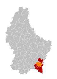
Map of Luxembourg with Bous-Waldbredimus highlighted in orange, and the canton in dark red
Coordinates: 49°33′30″N6°18′30″E / 49.5583°N 6.3083°E / 49.5583; 6.3083
Country Flag of Luxembourg.svg  Luxembourg
Canton Remich
Government
  Mayor Antonio Da Costa Araujo
Area
  Total
28.00 km2 (10.81 sq mi)
  Rank ? of 100
Highest elevation
359 m (1,178 ft)
  Rank ? of 100
Population
 (2024)
  Total
3,165
  Rank ? of 100
  Density110/km2 (290/sq mi)
   Rank ? of 100
Time zone UTC+1 (CET)
  Summer (DST) UTC+2 (CEST)
Website bouswaldbredimus.lu

Bous-Waldbredimus is a commune in south-eastern Luxembourg. It is part of the canton of Remich. It was established on 1 September 2023 with the merger of the communes of Bous and Waldbredimus.

Contents

History

According to the authorities responsible, the merger of the communities of Bous and Waldbredimus is about creating larger, sustainable communities that will be better positioned than the previous small communities by pooling resources and strengths. The state also pays a merger premium. In Bous, mergers with Stadtbredimus and Waldbredimus were possible, but in Waldbredimus there was also a merger with Weiler zum Turm and Dalheim. In a citizens' vote on 3 April 2022, 57% in Bous and 75% in Waldbredimus supported the merger of their communities. [1] The merger would take effect on 1 September 2023. [2]

Geography

Populated places

The commune consists of the following localities. The communal seat is shown in bold:

References

  1. "Gemeinden / Bous und Waldbredimus: Die Fusion ist beschlossene Sache". www.tageblatt.lu (in German). 7 April 2022. Retrieved 28 January 2023.
  2. "Legilux". public.lu. Retrieved 11 October 2023..