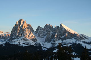
Mount Everest is Earth's highest mountain above sea level, located in the Mahalangur Himal sub-range of the Himalayas. The China–Nepal border runs across its summit point.

The Battle of Antietam, also known as the Battle of Sharpsburg, particularly in the Southern United States, was a battle of the American Civil War, fought on September 17, 1862, between Confederate General Robert E. Lee's Army of Northern Virginia and Union General George B. McClellan's Army of the Potomac, near Sharpsburg, Maryland and Antietam Creek. Part of the Maryland Campaign, it was the first field army–level engagement in the Eastern Theater of the American Civil War to take place on Union soil. It was the bloodiest day in United States military history, with a combined tally of 22,717 dead, wounded, or missing.

The First Battle of Bull Run, also known as the First Battle of Manassas, was the first major battle of the American Civil War and was a Confederate victory. The battle was fought on July 21, 1861 in Prince William County, Virginia, just north of the city of Manassas and about 25 miles west-southwest of Washington, D.C. The Union's forces were slow in positioning themselves, allowing Confederate reinforcements time to arrive by rail. Each side had about 18,000 poorly trained and poorly led troops in their first battle. It was a Confederate victory, followed by a disorganized retreat of the Union forces.

Col du Tourmalet is the highest paved mountain pass in the French Pyrenees, in the department of Hautes-Pyrénées. Sainte-Marie-de-Campan is at the foot on the eastern side and the ski station La Mongie two-thirds of the way up. The village of Barèges lies on the western side, above the town of Luz-Saint-Sauveur.

The American Legion, commonly known as the Legion, is an organization of U.S. war veterans headquartered in Indianapolis, Indiana. It is made up of state, U.S. territory, and overseas departments, and these are in turn made up of local posts. The organization was formed on March 15, 1919, in Paris, France, by a thousand officers and men of the American Expeditionary Forces, and it was chartered on September 16, 1919, by the United States Congress.

The Battle of Stones River was a battle fought from December 31, 1862, to January 2, 1863, in Middle Tennessee, as the culmination of the Stones River Campaign in the Western Theater of the American Civil War. Of the major battles of the war, Stones River had the highest percentage of casualties on both sides. Although the battle itself was inconclusive, the Union Army's repulse of two Confederate attacks and the subsequent Confederate withdrawal were a much-needed boost to Union morale after the defeat at the Battle of Fredericksburg, and it dashed Confederate aspirations for control of Middle Tennessee.

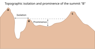
In topography, prominence measures the height of a mountain or hill's summit relative to the lowest contour line encircling it but containing no higher summit within it. It is a measure of the independence of a summit. A peak's key col is a unique point on this contour line and the parent peak is some higher mountain, selected according to various criteria.

The Sweet Track is an ancient trackway, or causeway, in the Somerset Levels, England, named after its finder, Ray Sweet. It was built in 3807 BC and is the second-oldest timber trackway discovered in the British Isles, dating to the Neolithic. It is now known that the Sweet Track was predominantly built along the course of an earlier structure, the Post Track.

In geomorphology, a col is the lowest point on a mountain ridge between two peaks. It may also be called a gap. Particularly rugged and forbidding cols in the terrain are usually referred to as notches. They are generally unsuitable as mountain passes, but are occasionally crossed by mule tracks or climbers' routes. The term col tends to be associated more with mountain rather than hill ranges.

Arette is a commune in the Pyrénées-Atlantiques department in the Nouvelle-Aquitaine region of southwestern France. It is located in the arrondissement of Oloron-Sainte-Marie and is one of the six communes of the canton of Aramits: the other five being Ance, Aramits (commune), Féas, Issor, and Lanne-en-Barétous.

Olympian was a large side-wheel inland steamship that operated in the Pacific Northwest and Alaska. Olympian operated from early 1884 to late 1891 on the Columbia River, Puget Sound, and the Inside Passage of British Columbia and Alaska.

Coles Creek culture is a Late Woodland archaeological culture in the Lower Mississippi valley in the Southeastern Woodlands. It followed the Troyville culture. The period marks a significant change in the cultural history of the area. Population increased dramatically and there is strong evidence of a growing cultural and political complexity, especially by the end of the Coles Creek sequence. Although many of the classic traits of chiefdom societies are not yet manifested, by 1000 CE the formation of simple elite polities had begun. Coles Creek sites are found in Arkansas, Louisiana, and Mississippi. It is considered ancestral to the Plaquemine culture.

Scotia was a barque that was built in 1872 as the Norwegian whaler Hekla. She was purchased in 1902 by William Speirs Bruce and refitted as a research vessel for use by the Scottish National Antarctic Expedition. After the expedition, she served as a sealer, patrol vessel and collier. She was destroyed by fire in January 1916.
The 1916 Birthday Honours were appointments by King George V to various orders and honours to reward and highlight good works by citizens of the British Empire. The appointments were made to celebrate the official birthday of The King, and were published in The London Gazette and in The Times on 3 June 1916.
The 1919 Birthday Honours were appointments by King George V to various orders and honours to reward and highlight good works by citizens of the British Empire. The appointments were made to celebrate the official birthday of The King, and were published in The London Gazette from 3 June to 12 August. The vast majority of the awards were related to the recently ended War, and were divided by military campaigns. A supplementary list of honours, retroactive to the King's birthday, was released in December 1919.
The 1918 New Year Honours were appointments by King George V to various orders and honours to reward and highlight good works by citizens of the British Empire. The appointments were published in The London Gazette and The Times in January, February and March 1918.
Lyra2 is a password hashing scheme (PHS) that can also work as a key derivation function (KDF). It received a special recognition during the Password Hashing Competition in July 2015., which was won by Argon2. Besides being used for its original purposes, it is also in the core of proof-of-work algorithms such as Lyra2REv2, adopted by Vertcoin, MonaCoin, among other cryptocurrencies Lyra2 was designed by Marcos A. Simplicio Jr., Leonardo C. Almeida, Ewerton R. Andrade, Paulo C. F. dos Santos, and Paulo S. L. M. Barreto from Escola Politécnica da Universidade de São Paulo.. It is an improvement over Lyra, previously proposed by the same authors. Lyra2 preserves the security, efficiency and flexibility of its predecessor, including: (1) the ability to configure the desired amount of memory, processing time and parallelism to be used by the algorithm; and (2) the capacity of providing a high memory usage with a processing time similar to that obtained with scrypt. In addition, it brings the following improvements when compared to its predecessor:


