The Wasatch Range is a mountain range that stretches approximately 160 miles (260 km) from the Utah-Idaho border, south through central Utah in the western United States. It is the western edge of the greater Rocky Mountains, and the eastern edge of the Great Basin region. The northern extension of the Wasatch Range, the Bear River Mountains, extends just into Idaho, constituting all of the Wasatch Range in that state.

Kings Peak is the highest peak in the U.S. state of Utah, with an elevation of 13,534 feet (4,125 m) NAVD 88 and an isolation of 166 miles.

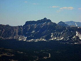
Mount Nebo is the southernmost and highest mountain in the Wasatch Range of Utah, in the United States. Named after the biblical Mount Nebo overlooking Israel, which is said to be the place of Moses' death, it is the centerpiece of the Mount Nebo Wilderness, inside the Uinta National Forest.

Mount Peale is the highest point in the La Sal Mountains of San Juan County, in the southeastern part of Utah, United States. It is also the highest point in Utah outside the Uinta Mountains. It is located about 20 mi (32 km) southeast of Moab. The summit is the highest point in the Manti-La Sal National Forest and the Mount Peale Research Natural Area. Mount Peale was named for Albert Peale, a mineralogist on the Hayden Survey of 1875.

The Uinta Basin is a physiographic section of the larger Colorado Plateaus province, which in turn is part of the larger Intermontane Plateaus physiographic division. It is also a geologic structural basin in eastern Utah, east of the Wasatch Mountains and south of the Uinta Mountains. The Uinta Basin is fed by creeks and rivers flowing south from the Uinta Mountains. Many of the principal rivers flow into the Duchesne River which feeds the Green River—a tributary of the Colorado River. The Uinta Mountains forms the northern border of the Uinta Basin. They contain the highest point in Utah, Kings Peak, with a summit 13,528 feet above sea level. The climate of the Uinta Basin is semi-arid, with occasionally severe winter cold.

Bald Mountain is a peak in the western Uinta Mountain Range in northeastern Utah, United States. It is an easy hike from Bald Mountain Pass, and has views of the surrounding areas. The mountain is home to mountain goats, pika, and a number of species of wildflowers.

Mount Agassiz is a peak in the Uinta Mountains of northeastern Utah with an elevation of 12,433 feet (3,790 m). It is located in the High Uintas Wilderness and the Uinta-Wasatch-Cache National Forest. The summit is named in honor of Louis Agassiz, a well-known paleontologist, glaciologist and geologist.

Logan Peak, commonly referred to as Mount Logan, is a peak in the Bear River Mountains, a branch of the Wasatch Range. Located six miles east-southeast of Logan, Utah in the Uinta-Wasatch-Cache National Forest, it is the second highest peak overlooking Cache Valley after Mt. Naomi. Logan Peak rises to an elevation of 9,714 feet (2,961 m) NAVD88. It is served by hiking trails and a narrow, unpaved access road suitable only for offroad vehicles. It is the only mountain in the Bear River Range with a road to the summit. The peak houses a weather station and a telecommunications tower. Logan Peak is a popular destination for hikers and mountain bikers during the warmer months and advanced cross-country skiers in winter. During the winter, a circular hollow on the east side of the peak, known locally as Crystal Valley, is popular with snowmobilers.

The High Uintas Wilderness is a wilderness area located in northeastern Utah, United States. The wilderness covers the Uinta Mountains, encompassing parts of Duchesne and Summit counties. Designated as a wilderness in 1984, the area is located within parts of Ashley National Forest and Uinta-Wasatch-Cache National Forest, managed by the U.S. Forest Service. The highest peak in Utah, Kings Peak, lies within the wilderness area along with some of Utah's highest peaks, particularly those over 13,000 feet.

Mount Chittenden el. 10,182 feet (3,103 m) is a mountain peak in the Absaroka Range in Yellowstone National Park. The peak was named by Henry Gannett of the Hayden Geological Survey of 1878 for George B. Chittenden. Chittenden was a Geological Survey member who had worked with Gannett, Hayden and others in surveys in Montana, Idaho and Wyoming. Chittenden never participated in any of the Yellowstone surveys.

Humpy Peak is a peak located in the Uinta Mountain Range in northern Utah. It is approximately 27.56 miles (44 km) south of Evanston, Wyoming and 21.29 miles (34 km) east of Coalville, Utah. The summit has an elevation of 10,875 feet (3,315 m).
Kletting Peak is a mountain in Summit County, Utah, named in 1964 for Utah architect Richard K.A. Kletting (1858-1943). It is in the High Uintas Wilderness and the Uinta-Wasatch-Cache National Forest.

Twin Peaks Wilderness is a 11,396 acres (46.12 km2) wilderness area in the Wasatch Range of Uinta-Wasatch-Cache National Forest in Salt Lake County, Utah, United States. The Mount Olympus Wilderness is directly north of the Twin Peaks Wilderness and separated by Utah State Route 190. The Lone Peak Wilderness is directly to the south and separated by Utah State Route 210. Elevations in the wilderness range from under 5,000 feet (1,500 m) to 11,330 feet (3,450 m) on Twin Peaks.

Zenobia Peak, elevation 9,022 ft (2,750 m), is the highest summit in Dinosaur National Monument of Moffat County, Colorado.
Tanks Peak, elevation 8,726 ft (2,660 m), is a summit in the Uinta Range located northeast of Dinosaur in Moffat County, Colorado.
South Kings Peak is the second highest peak in Utah, United States with an elevation of 13,518 feet (4,120 m). It lies just south of the spine of the central Uinta Mountains, in the Ashley National Forest in northeastern Utah, in north-central Duchesne County. It lies within the boundaries of the High Uintas Wilderness.
Mount Emmons is a summit in Duchesne County, Utah, United States. It is located within the Ashley National Forest and the High Uintas Wilderness. It is situated about 5.76 miles (9.27 km) southeast of Kings Peak and has an elevation of 13,448 feet (4,099 m).
Uintah Lake is one of many lakes in Uinta Mountains in Duchesne County, Utah, United States. The lake is at an elevation of 10,945 feet (3,336 m).

Provo Peak is a mountain peak in the Uinta National Forest in the Wasatch Range that is located within the city limits Provo, Utah, United States. The peak has an elevation of 11,068 feet (3,374 m), but a prominence of only 3,442 feet (1,049 m). Although located along the Wasatch Front, it is situated behind (east-southeast) of Y Mountain.