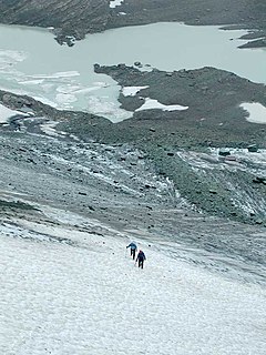
Chaney Glacier is in Glacier National Park in the U.S. state of Montana. The glacier is situated in a cirque to the southeast of Mount Kipp on the eastern side of the Continental Divide. Chaney Glacier is one of several glaciers that have been selected for monitoring by the U.S. Geological Survey's Glacier Monitoring Research program, which is researching changes to the mass balance of glaciers in and surrounding Glacier National Park. The glacier is being monitored using remote sensing equipment and repeat photography, where images of the glacier are taken from identical locations periodically.

Belly River is a river in northwest Montana, United States and southern Alberta, Canada. It is a tributary of the Oldman River, itself a tributary of the South Saskatchewan River.

The following articles relate to the history, geography, geology, flora, fauna, structures and recreation in Glacier National Park (U.S.), the U.S. portion of the Waterton-Glacier International Peace Park.

Ahern Peak is located in the Lewis Range, Glacier National Park in the U.S. state of Montana. The mountain was named after George Patrick Ahern. Ahern Peak is immediately southwest of Helen Lake and straddles the Continental Divide. Ahern Glacier lies just north of the peak.

Shepard Glacier is a glacier remnant (glacieret) In Glacier National Park in the U.S. state of Montana. The glacieret is immediately southeast of Cathedral Peak. Shepard Glacier was one of a number of glaciers that have been documented by the United States Geological Service (USGS) to have retreated significantly in Glacier National Park. Shepard Glacier was measured in 2009 to have decreased to less than 25 acres (0.10 km2), considered to be a minimal size to qualify as being considered an active glacier. Between 1966 and 2005, Shepard Glacier lost 56 percent of its surface area.

Iceberg Peak is located in the Lewis Range, Glacier National Park in the U.S. state of Montana. Iceberg Peak rises more than 3,000 feet (910 m) above Iceberg Lake and is considered a difficult climb due to the steepness and exposure climbers must endure. The peak sits astride the continental divide 1.1 mi (1.8 km) WNW of Mount Wilbur.
Ipasha Peak is located in the Lewis Range, Glacier National Park in the U.S. state of Montana. Ipasha Peak is 1.29 miles (2.08 km) south of Mount Merritt and is in the northeastern section of Glacier National Park. Ahern Glacier is located on the southeastern slopes of the mountain while the Ipasha Glacier is to the southwest of the peak. Helen Lake lies almost 4,500 feet (1,400 m) below the summit of Ipasha Peak to the southeast.

Pyramid Peak is in the Lewis Range, Glacier National Park in the U.S. state of Montana. Mokowanis Lake lies just northeast of the peak, and Atsina Lake is to the west.
Ahern Glacier is in Glacier National Park in the U.S. state of Montana. The glacier was named after George Patrick Ahern. Ahern Glacier is situated on a ridge between Ipasha Peak to the north and Ahern Peak to the south at an elevation between 8,800 feet (2,700 m) and 8,000 feet (2,400 m) above sea level, immediately east of the Continental Divide. Meltwater from the glacier feeds Ahern Glacier Falls, a waterfall which descends an estimated 1,680 feet (510 m) in one sheer drop to a talus slope below en route to Helen Lake. Between 1966 and 2005, Ahern Glacier lost 13 percent of its surface area.
Ipasha Glacier is located in the US state of Montana in Glacier National Park. The glacier is situated in a cirque to the southeast of Chaney Glacier and immediately east of the Continental Divide at an elevation between 8,000 feet (2,400 m) and 7,600 feet (2,300 m) above sea level. The glacier covers an area of approximately 52 acres (0.21 km2) as measured in 2005, which is a third smaller than it was in 1966. Melt water from the glacier flows over Ipasha Falls en route to Ipasha Lake.
Upper Two Medicine Lake is located in Glacier National Park, in the U. S. state of Montana. The lake is just east of the Continental Divide in the Two Medicine region of Glacier National Park. Upper Two Medicine Lake is in a cirque and surrounded by a number of peaks including Lone Walker Mountain, Mount Helen and Pumpelly Pillar. Upper Two Medicine Lake is a 5 miles (8.0 km) hike from the Two Medicine Store.
Twin Lakes are located in Glacier National Park, in the U. S. state of Montana. Fusillade Mountain rises to the south above the lakes. A spur off the Gunsight Pass Trail leads to Florence Falls which are below the Twin Lakes.
Natahki Lake is located in Glacier National Park, in the U. S. state of Montana. Natahki Lake is in a cirque below Mount Henkel to the west and south and Altyn Peak to the southeast.
Ipasha Lake is located in Glacier National Park, in the U. S. state of Montana. Ipasha Lake is west of Ipasha Peak which rises more than 4,000 feet (1,200 m) above the lake. Melt water from the Ipasha Glacier descends 580 feet (180 m) over Ipasha Falls en route to Ipasha Lake.

Sue Lake is located in Glacier National Park, in the U. S. state of Montana. Sue Lake is situated immediately northwest of Mount Kipp. Immediately after flowing out of Sue Lake, the Mokowanis River descends 560 feet (170 m) over Raven Quiver Falls.
Margaret Lake is located in Glacier National Park, in the U. S. state of Montana. Margaret Lake is less than .50 miles (0.80 km) north of Ipasha Lake. Margaret Lake is fed by Pyramid Creek as well as melt waters from Chaney Glacier.
Atsina Lake is in Glacier National Park in the U. S. state of Montana, just to the west of Pyramid Peak. Atsina Lake has several waterfalls nearby including Paiota Falls, Atsina Falls and the Mokowanis Cascade.
Otatso Lake is located in Glacier National Park, in the U. S. state of Montana. Otatso Lake is situated in a cirque below unnamed peaks in the northeastern section of Glacier National Park.

The Regional designations of Montana vary widely within the U.S state of Montana. The state is a large geographical area that is split by the Continental Divide, resulting in watersheds draining into the Pacific Ocean, Gulf of Mexico and Hudson's Bay. The state is approximately 545 miles (877 km) east to west along the Canada–United States border and 320 miles (510 km) north to south. The fourth largest state in land area, it has been divided up in official and unofficial ways into a variety of regions. Additionally, Montana is part of a number of larger federal government administrative regions.
Ipasha Falls is a waterfall located in Glacier National Park, Montana, US. Ipasha Falls descends from Ipasha Glacier to Ipasha Lake and is recorded as having a drop of at least 800 feet (240 m). Located in a remote region north of Many Glacier, the falls can only been seen by a multiday hike on established trails to Mokowanis Lake and then from there along unmaintained trails to Ipasha Lake.


