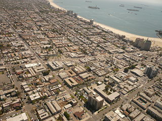
The Hellman neighborhood of Long Beach, California, seen from the air, facing southeast. Alamitos Avenue runs across the photo at the bottom, 7th Street runs from the bottom right corner to the top of the photo, and 10th Street runs from the bottom left to the top. Hellman Street cuts diagonally across the center.
This area is located north of 7th Street, south of 10th Street, between Orange & Walnut Ave.
A high concentration of Craftsman bungalows, built for middle-class working families, remains intact today in this district. Secondary "contributing" structures are Spanish Colonial Revival and Victorian.
Isaias W. Hellman, businessman, financier and real estate developer prominent in Los Angeles and Long Beach, is credited[by whom?] with developing this neighborhood. Hellman Street bears his name.
Location
The greater Hellman neighborhood is bordered by Alamitos Avenue to the west, Anaheim Street to the north, Cherry Avenue to the east, and 7th Street to the south.
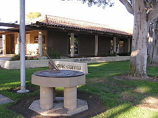
Los Alamitos is a city in Orange County, California. The city was incorporated in March 1960. The population was 11,449 at the 2010 census, down from 11,536 at the 2000 census. The adjacent unincorporated community of Rossmoor uses the same 90720 Zip Code in its mailing address, but is not part of the city. The Los Alamitos Race Course is named for the city, but lies in the neighboring city of Cypress.
West Adams is a historic neighborhood in the South Los Angeles region of Los Angeles, California. The area is known for its large number of historic buildings, structures and notable houses and mansions throughout Los Angeles. It is a youthful, densely populated area with a high percentage of African American and Latino residents. The neighborhood has several public and private schools.
The East Village, sometimes called the "East Village Arts District," is the name of a neighborhood in Long Beach, California, within eastern Downtown Long Beach. The borders of the East Village are not strictly defined, but the area is centered in the southeast portion of downtown, roughly between Long Beach Boulevard on the west and Alamitos Avenue on the east, and Ocean Boulevard on the south to 10th Street on the north.
Downtown Long Beach is the heart of Long Beach, California, United States, and is the location for most of the city's major tourist attractions and municipal services. It is also the location for numerous businesses. There are many hotels and restaurants in the area that serve locals, tourists, and convention visitors.
The term Eastside or East Side has two different meanings in the city of Long Beach, California. The first, and more current meaning, refers to an area roughly comprising the eastern half of the city, usually excluding areas south of the east-west line made by Pacific Coast Highway/Atherton Street. This area is also called East Long Beach.
Belmont Heights is a district in the south-east portion of the city of Long Beach, California, United States, bordering the Pacific Ocean and the more commercial community of Belmont Shore. The district commemorates the old City of Belmont Heights, which was incorporated in 1908 and annexed to Long Beach in 1909. Belmont Heights' borders are Ocean Boulevard and Livingston Drive to the south, Redondo Avenue on the west, 7th Street to the North, and Nieto Avenue to the east. The area is mostly residential, but also has an active business district, the strip of Broadway east of Redondo Avenue.
Bluff Park is a small, upscale neighborhood in Long Beach, California, United States. There is a bluff along much of the beach in Long Beach, and on one stretch, there is the narrow Bluff Park from which the neighborhood gets its name.
Belmont Shore is a neighborhood in Long Beach, California. It is home to many shops, restaurants, salons and business offices.
West Long Beach is a working-class neighborhood in Long Beach, California.
North Long Beach is a predominantly working-class area of Long Beach, California. The neighborhood is bounded to the west, north and east by the Long Beach city limits, and to the south by Del Amo Boulevard and the Bixby Knolls neighborhood. The north boundary with Paramount is only a few blocks north of the Artesia Freeway.
Wrigley is a district in Long Beach, California. Its name derives from William Wrigley Jr., the owner and founder of the famed Wrigley Spearmint Gum Empire in Chicago. It was one of the first communities established in Long Beach. The original subdivision pattern was established in 1905. The area is developed throughout on a gridiron street pattern. Homes on 48 lots were developed by William Wrigley's company between 1928 and 1934. These blocks of homes now form the Wrigley Landmark District.
Bixby Knolls is a neighborhood in Long Beach, California.
Bluff Heights is a neighborhood in Long Beach, California, composed mainly of Craftsman bungalows constructed from approximately 1910 to 1923.
Rose Park and Rose Park South are two neighborhoods in Long Beach, California.
The Long Beach Police Department provides law enforcement for the city of Long Beach, California.
Alamitos Beach is a coastal neighborhood in the southern portion of the city of Long Beach, California. Although it was in unincorporated Los Angeles County when annexed by the City of Long Beach, it had been planned as its own community with a townsite.
Alamitos Heights is a neighborhood in the south-east portion of the city of Long Beach, California, United States.
Carroll Park is a neighborhood in the city of Long Beach, California.
The 4th Street Corridor, also known as Retro Row, is a small business district in the city of Long Beach, California, along 4th Street from Walnut Avenue to Temple Avenue.
Sunrise, also known as Sunrise Boulevard, is a neighborhood in the city of Long Beach, California. In 1990, the City of Long Beach by Ordinance C-6834 designated this neighborhood as the "Sunrise Boulevard Historic Landmark District."
This page is based on this Wikipedia article Text is available under the CC BY-SA 4.0 license; additional terms may apply. Images, videos and audio are available under their respective licenses.