East Village, Long Beach, California

Last updated
East Village, California
East Village Long Beach California.JPG
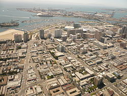
The East Village district of Long Beach, California, is in the right three-quarters of the foreground of this southwest-facing photo (the Alamitos Beach neighborhood makes up the left quarter of the foreground, on the east side of Alamitos Avenue, the diagonal street on the left). Downtown Long Beach is to the right. Queensway Bay/San Pedro Bay are visible, with the Queen Mary and part of the Port of Long Beach in the distance. Catalina Island is faintly visible on the horizon.
Country Flag of the United States.svg United States
State Flag of California.svg  California
County Flag of Los Angeles County, California.svg Los Angeles
City Flag of Long Beach, California.png Long Beach

The East Village, sometimes called the "East Village Arts District," is the name of a neighborhood in Long Beach, California, within eastern Downtown Long Beach. The borders of the East Village are not strictly defined, but the area is centered in the southeast portion of downtown, roughly between Long Beach Boulevard on the west and Alamitos Avenue on the east, and Ocean Boulevard on the south to 10th Street on the north.

Contents

The East Village is a mix of many different housing types, including high-rise condos, artist lofts and small craftsman cottages. It serves as the home to individuals with differing cultures, income levels, and professions.

The neighborhood has many independent stores selling everything from designer denim and specialty sneakers to used books and mid-century furniture. There are coffee shops, juice bars, and restaurants featuring selections from crepes and sushi to chicken n' waffles.

The East Village is also the city's arts district, with most of the independent shops, restaurants and galleries exhibiting work by Long Beach and Southern Californian artists. [1]

See also

Related Research Articles

Long Beach, California City in California, United States

Long Beach is a city in Los Angeles County, California. It is the 42nd-most populous city in the United States, with a population of 466,742 as of 2020. A charter city, Long Beach is the seventh-most populous city in California.

Manhattan Beach, California City in California, United States

Manhattan Beach is a city in southwestern Los Angeles County, California, United States, on the Pacific coast south of El Segundo, west of Hawthorne and Redondo Beach, and north of Hermosa Beach. As of the 2010 census, the population was 35,135, and in 2019 the population was estimated to be 35,183.

Terminal Island Island in Los Angeles County, California, United States

Terminal Island, historically known as Isla Raza de Buena Gente, is a largely artificial island located in Los Angeles County, California, between the neighborhoods of Wilmington and San Pedro in the city of Los Angeles, and the city of Long Beach. Terminal Island is roughly split between the Port of Los Angeles and Port of Long Beach. Land use on the island is entirely industrial and port-related except for Federal Correctional Institution, Terminal Island.

Huell Howser

Huell Burnley Howser was an American television personality, actor, producer, writer, singer, and voice artist, best known for hosting, producing, and writing California's Gold, his human interest show, Visiting with Huell Howser, produced by KCET in Los Angeles for California PBS stations. The archive of his video chronicles offers an enhanced understanding of the history, culture, and people of California. He also voiced the Backson in Winnie the Pooh (2011).

Arrowhead Springs, San Bernardino Neighborhood of San Bernardino in California, United States

Arrowhead Springs is a highly mountainous neighborhood in the 81-square-mile (210 km2) municipality of San Bernardino, California, officially annexed to the city on November 19, 2009. The neighborhood lies below the Arrowhead geological monument, which is California Historical Landmark #977.

West Adams, Los Angeles Neighborhood of Los Angeles in California, United States

West Adams is a historic neighborhood in the South Los Angeles region of Los Angeles, California. The area is known for its large number of historic buildings, structures and notable houses and mansions throughout Los Angeles. It is a youthful, densely populated area with a high percentage of African American and Latino residents. The neighborhood has several public and private schools.

Jefferson Park, Los Angeles Neighborhood of Los Angeles in California, United States

Jefferson Park is a neighborhood in the South region of the City of Los Angeles, California.

Wilshire Boulevard Major thoroughfare in the metropolitan Los Angeles area, United States

Wilshire Boulevard is a prominent 15.83 mi (25.48 km) boulevard in the Los Angeles area of Southern California, extending from Ocean Avenue in the city of Santa Monica east to Grand Avenue in the Financial District of downtown Los Angeles. One of the principal east-west arterial roads of Los Angeles, it is also one of the major city streets through the city of Beverly Hills. Wilshire Boulevard runs roughly parallel with Santa Monica Boulevard from Santa Monica to the west boundary of Beverly Hills. From the east boundary it runs a block south of Sixth Street to its terminus.

Downtown Long Beach Neighborhood of Long Beach in Los Angeles, California, United States

Downtown Long Beach is the heart of Long Beach, California, United States, and is the location for most of the city's major tourist attractions and municipal services. It is also the location for numerous businesses. There are many hotels and restaurants in the area that serve locals, tourists, and convention visitors.

The Agua Caliente Band of Cahuilla Indians of the Agua Caliente Indian Reservation is a federally recognized tribe of the Cahuilla, located in Riverside County, California. They inhabited the Coachella Valley desert and surrounding mountains between 5000 BCE and 500 CE. With the establishment of the reservations, the Cahuilla were officially divided into 10 sovereign nations, including the Agua Caliente Band.

Belmont Heights, Long Beach, California Neighborhood of Long Beach in Los Angeles, California, United States

Belmont Heights is a district in the south-east portion of the city of Long Beach, California, United States, bordering the Pacific Ocean and the more commercial community of Belmont Shore. The district commemorates the old City of Belmont Heights, which was incorporated in 1908 and annexed to Long Beach in 1909. Belmont Heights' borders are Ocean Boulevard and Livingston Drive to the south, Redondo Avenue on the west, 7th Street to the North, and Nieto Avenue to the east. The area is mostly residential, but also has an active business district, the strip of Broadway east of Redondo Avenue.

Belmont Shore, Long Beach, California Neighborhood of Long Beach in Los Angeles, California, United States of America

Belmont Shore is a neighborhood in Long Beach, California. It is home to many shops, restaurants, salons and business offices.

Venice Boulevard is a major east–west thoroughfare in Los Angeles, running from the ocean in the Venice district, past the I-10 intersection, into downtown Los Angeles. It was originally known as West 16th Street under the Los Angeles numbered street system.

The western border of Santa Monica, California is the 3-mile (4.8 km) stretch of Santa Monica Bay. On its other sides, the city is bordered by various districts of Los Angeles: the northwestern border is Pacific Palisades, the eastern border is Brentwood north of Wilshire Boulevard and West Los Angeles south of Wilshire, the northeastern border is generally San Vicente Boulevard up to the Riviera Country Club, the southwestern border is Venice Beach and the southern border is with West Los Angeles and Mar Vista.

Fishermans Village Tourist attraction in Marina del Rey, California, USA

Fisherman's Village is a waterfront mall, commercial boat anchorage and tourist attraction located in the world's largest man-made small boat harbor in Los Angeles County at Marina del Rey, California. The Ballona Wetlands State Ecological Reserve is immediately east of Fisherman's Village and immediately to the south is the federally-owned riverine estuary of Ballona Creek. The historical Fisherman's Village that was built 53 years ago in 1967 is nestled on the eastern bank of main harbor entrance channel between Whiskey Reds restaurant to the south and the Windward boatyard to the north.

Pink's Hot Dogs is a landmark hot dog restaurant in the Fairfax District of the city of Los Angeles. It is on North La Brea Avenue, across the street from the Hollywood district on the east.

Subway Terminal Building Building in California, United States

The historic Subway Terminal, now Metro 417, opened in 1925 at 417 South Hill Street near Pershing Square, in the core of Los Angeles as the second, main train station of the Pacific Electric Railway; it served passengers boarding trains for the west and north of Southern California through a mile-long shortcut under Bunker Hill popularly called the "Hollywood Subway," but officially known as the Belmont Tunnel. The station served alongside the Pacific Electric Building at 6th & Main, which opened in 1905 to serve lines to the south and east. The Subway Terminal was designed by Schultze and Weaver in an Italian Renaissance Revival style, and the station itself lay underground below offices of the upper floors, since repurposed into the Metro 417 luxury apartments. When the underground Red Line was built, the new Pershing Square station was cut north under Hill Street alongside the Terminal building, divided from the Subway’s east end by just a retaining wall. At its peak in the 20th century, the Subway Terminal served upwards of 20 million passengers a year.

Alamitos Beach, Long Beach, California Neighborhood of Long Beach in Los Angeles, California, United States

Alamitos Beach is a coastal neighborhood in the southern portion of the city of Long Beach, California. Although it was in unincorporated Los Angeles County when annexed by the City of Long Beach, it had been planned as its own community with a townsite.

Whittier Boulevard Street in Los Angeles County

Whittier Boulevard known as Stephenson Avenue is an arterial street that runs from the Los Angeles River to Brea, California. The street is one of the main thoroughfares in both Whittier and East Los Angeles. At various times, portions of Whittier Boulevard carried the designation of U.S. Route 101. Whittier Boulevard also carries a portion of El Camino Real. Its west section leading from the Sixth Street Viaduct was demolished in 2016. Currently, Whittier Boulevard carries two Caltrans controlled highways. The portion between Rosemead Boulevard and Beach Boulevard carries State Route 72 and the portion between Beach and Harbor Boulevards carries California State Route 39. The portion of State Route 72 up to State Route 19 was relinquished back to Pico Rivera in the early 2000s and the portion of State Route 72 between State Route 19 and Downey Road was deleted from SR 72 in 1992.

References

  1. "Long Beach Post - LBT's Major Changes In Effect: Altered Routes, Cleaner Buses, Mobile Site". lbpost.com. Archived from the original on 2012-08-31.
  2. "Soundwalk – Visiting (1612) – Huell Howser Archives at Chapman University".
  3. "The Lafayette Long Beach * Introduction". www.thelafayettelb.org.
  4. "The Lafayette Long Beach * History". www.thelafayettelb.org.
  5. "The Broadlind Hotel". Broadlind Hotel LB.

Coordinates: 33°46′17″N118°11′06″W / 33.7715°N 118.1851°W / 33.7715; -118.1851