Related Research Articles

The Sacramento River is the principal river of Northern California in the United States and is the largest river in California. Rising in the Klamath Mountains, the river flows south for 400 miles (640 km) before reaching the Sacramento–San Joaquin River Delta and San Francisco Bay. The river drains about 26,500 square miles (69,000 km2) in 19 California counties, mostly within the fertile agricultural region bounded by the Coast Ranges and Sierra Nevada known as the Sacramento Valley, but also extending as far as the volcanic plateaus of Northeastern California. Historically, its watershed has reached as far north as south-central Oregon where the now, primarily, endorheic (closed) Goose Lake rarely experiences southerly outflow into the Pit River, the most northerly tributary of the Sacramento.

The Central Valley is a broad, elongated, flat valley that dominates the interior of California. It is 40–60 mi (60–100 km) wide and runs approximately 450 mi (720 km) from north-northwest to south-southeast, inland from and parallel to the Pacific coast of the state. It covers approximately 18,000 sq mi (47,000 km2), about 11% of California's land area. The valley is bounded by the Coast Ranges to the west and the Sierra Nevada to the east.

Clovis is a city in Fresno County, California, United States. Clovis was established in 1890 as a freight stop for the San Joaquin Valley Railroad by a group of Fresno businessmen and Michigan railroad speculator Marcus Pollasky. The railroad bought the land from two farmers and named the station after one of them, Clovis Cole. Pollasky then developed a town on the site, also named Clovis.

The San Joaquin River is the longest river of Central California. The 366-mile (589 km) long river starts in the high Sierra Nevada, and flows through the rich agricultural region of the northern San Joaquin Valley before reaching Suisun Bay, San Francisco Bay, and the Pacific Ocean. An important source of irrigation water as well as a wildlife corridor, the San Joaquin is among the most heavily dammed and diverted of California's rivers.

The Kings River, historically called Wimmel-che by the Yokuts, is a 132.9-mile (213.9 km) river draining the Sierra Nevada mountain range in central California in the United States. Its headwaters originate along the Sierra Crest in and around Kings Canyon National Park and form the eponymous Kings Canyon, one of the deepest river gorges in North America. The river is impounded in Pine Flat Lake before flowing into the San Joaquin Valley southeast of Fresno. With its upper and middle course in Fresno County, the Kings River diverges into multiple branches in Kings County, with some water flowing south to the old Tulare Lake bed and the rest flowing north to the San Joaquin River. However, most of the water is consumed for irrigation well upstream of either point.

The Governor Edmund G. Brown California Aqueduct is a system of canals, tunnels, and pipelines that conveys water collected from the Sierra Nevada Mountains and valleys of Northern and Central California to Southern California. Named after California Governor Edmund Gerald "Pat" Brown Sr., the over 400-mile (640 km) aqueduct is the principal feature of the California State Water Project.

The Sacramento–San Joaquin River Delta, or California Delta, is an expansive inland river delta and estuary in Northern California. The Delta is formed at the western edge of the Central Valley by the confluence of the Sacramento and San Joaquin rivers and lies just east of where the rivers enter Suisun Bay, which flows into San Francisco Bay, then the Pacific Ocean via San Pablo Bay. The Delta is recognized for protection by the California Bays and Estuaries Policy. Sacramento–San Joaquin Delta was designated a National Heritage Area on March 12, 2019. The city of Stockton is located on the San Joaquin River at the eastern edge of the delta. The total area of the Delta, including both land and water, is about 1,100 square miles (2,800 km2). Its population is around 500,000.

The Yolo Bypass is one of the two flood bypasses in California's Sacramento Valley located in Yolo and Solano Counties. Through a system of weirs, the bypass diverts floodwaters from the Sacramento River away from the state's capital city of Sacramento and other nearby riverside communities.
The Delta–Mendota Canal is a 117-mile-long (188 km) aqueduct in central California, United States. The canal was designed and completed in 1951 by the U.S. Bureau of Reclamation as part of the Central Valley Project. It carries freshwater to replace San Joaquin River water which is diverted into the Madera Canal and Friant-Kern Canal at Friant Dam.
San Joaquin College of Law (SJCL) is a private law school in Clovis, California.

The Fresno River is a river in Central California and a major tributary of the San Joaquin River. It runs approximately 83 miles (134 km) from the Sierra Nevada Range to the San Joaquin River if measured from the source of Rainier Creek, near Raymond Mountain in Yosemite National Park. Although called the 'Fresno' River, it is one of the largest and longest river systems in Madera County.
The Chowchilla River is a river in central California, United States and a minor tributary of the San Joaquin River. It flows for 54.2 miles (87.2 km) from the western side of the Sierra Nevada Range to the San Joaquin River system in the San Joaquin Valley.

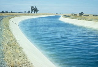
The Friant-Kern Canal is a 152 mi (245 km) aqueduct managed by the United States Bureau of Reclamation in Central California to convey water to augment irrigation capacity in Fresno, Tulare, and Kern counties. A part of the Central Valley Project, canal construction began in 1949 and was completed in 1951 at a cost of $60.8 million.

Mammoth Pool Dam is a hydroelectric dam located on the San Joaquin River in the southern Sierra Nevada mountain range of California, about 45 miles (72 km) northeast of Fresno. It forms Mammoth Pool Reservoir and lies within the Sierra National Forest. The dam and reservoir were named after a large natural pool in the river that was once located above the present dam site.
Pueblo de las Juntas is a former settlement in Fresno County, California situated at the confluence of the San Joaquin River and Fresno Slough, 2 miles (3.2 km) north of Mendota.

Buena Vista Slough was the joint outlet of an overflowing Buena Vista Lake and a distributary of the Kern River into Tulare Lake. It is now diverted into a system of canals by the Outlet Canal of the Central Valley Project.

Spud Island is a small island of the San Joaquin River, located in the Sacramento–San Joaquin River Delta in northern California. It was once used to farm onions; while it is no longer used for agriculture, it remains inhabited. In the late 20th century it was the site of a county park, which offered camping, fishing and swimming amenities free of charge.
References
- ↑ Michael K. Saiki, Barbara Martin, et al., Effects of an Agricultural Drainwater Bypass on Fishes Inhabiting the Grassland Water District and the Lower San Joaquin River, California, North American Journal of Fisheries Management, vol. 21, issue 3 pp 624-635 (2001)
- ↑ Phase I Environmental Site Assessment, Clovis Towne Center, Clovis, California, Earth Metrics Inc report 10283, October, 1989
- ↑ U.S. Geological Survey, Clovis, California, 7.5 Minute Quadrangle, 1964, photorevised 1972) and groundwater generally flows to the southwest