
Letchworth State Park is a 14,427-acre (5,838 ha) New York State Park located in Livingston County and Wyoming County in the western part of the State of New York. The park is roughly 17 miles (27 km) long, following the course of the Genesee River as it flows north through a deep gorge and over several large waterfalls. It is located 35 miles (56 km) southwest of Rochester and 60 miles (97 km) southeast of Buffalo, and spans portions of the Livingston County towns of Leicester, Mount Morris and Portage, as well as the Wyoming County towns of Castile and Genesee Falls.

Franklin is a town in and the county seat of Macon County, North Carolina, United States. It is situated within the Nantahala National Forest. The population was reported to be 4,175 in the 2020 census, an increase from the total of 3,845 tabulated in 2010.

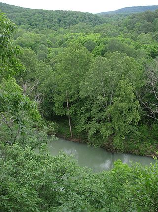
The Buffalo River, located in Northern Arkansas, was the first National River to be designated in the United States. The Buffalo River is 153 miles (246 km) long. The lower 135 miles (217 km) flow within the boundaries of an area managed by the National Park Service, where the stream is designated the Buffalo National River. The river flows through Newton, Searcy, Marion, and Baxter Counties, from west to east. The river originates in the highest part of the Boston Mountains of the Ozarks, flows out onto the Springfield Plateau near the historic community of Erbie, and finally crosses a portion of the Salem Plateau just before joining the White River. The Park is home to the state's only elk herd. The upper section of the river in the Ozark National Forest is managed by the U.S. Forest Service and is designated as a National Scenic River and a National Wild River; that section is not part of the area managed as a park by the Park Service but is managed as a part of the Ozark National Forest.

The Mist Trail is one of the most popular short hikes in Yosemite National Park, California, USA. The steep hike follows the Merced River, starting at Happy Isles in Yosemite Valley, past Vernal Fall and Emerald Pool, to Nevada Fall.

Nevada Fall is a 594-foot (181 m) high waterfall on the Merced River in Yosemite National Park, California. It is located below the granite dome, Liberty Cap, at the west end of Little Yosemite Valley. The waterfall is widely recognized by its "bent" shape, in which the water free-falls for roughly the first third of its length to a steep slick-rock slope. This mid-fall impact of the water on the cliff face creates a turbulent, whitewater appearance in the fall and produces a great deal of mist which covers a wide radius, which led to its current name.
Taconic State Park is located in Columbia and Dutchess County, New York abutting Massachusetts and Connecticut within the Taconic Mountains. The state park is located off New York State Route 344 south of Interstate 90 and 110 miles (180 km) north of New York City. It features camping, hiking, bicycling, hunting, cross county skiing and other recreational opportunities.

The Great Smoky Mountains National Park is a United States National Park located in a region of the Appalachian Mountains referred to as the Great Smoky Mountains, in a portion of east-central Tennessee and southwest North Carolina. With over 150 hiking trails extending for more than 850 miles (1,370 km), within its boundaries, including a seventy-mile segment of the Appalachian Trail, hiking is the most popular activity in the national park.
The Buffalo River Trail is a hiking and backpacking trail that follows the path of the Buffalo National River in Arkansas. It consists of two separate sections that are referred to as the Western and Eastern sections. The Western Section is from Boxley Valley to Pruitt. The Eastern Section is from Woolum Ford to Highway 14. The Ozark Highlands Trail joins the Eastern Section of the Buffalo River Trail at Woolum Ford so it is officially designated the Buffalo River/Ozark Highlands Trail.

Gulf Hagas is a gorge located in the mountains of northern Maine woods and is often referred to as the Grand Canyon of Maine. The West Branch of the Pleasant River cuts through the earth for three miles creating a vertically walled slate gorge with numerous waterfalls. A trail follows the rim of the canyon offering hikers views of the falls and its geology. The gorge is 3 miles (4.8 km) long; the river drops 370 feet (110 m) in this distance boasting 130 feet (40 m) walls. Gulf Hagas is one of 14 National Natural Landmarks in the State of Maine, and is open to the public for a fee during the regular season.

Darwin Falls is a waterfall located on the western edge of Death Valley National Park near the settlement of Panamint Springs, California. Although there exists a similarly named Darwin Falls Wilderness adjacent to the falls, the falls themselves are located in and administered by Death Valley National Park and the National Park Service. There are several falls, but they are mainly divided into the upper and lower, with a small grotto in between. At a combined 80 feet (24 m), it is the highest waterfall in the park. The canyon is walled by dramatic plutonic rock.
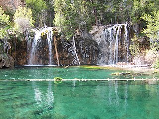
Hanging Lake is a lake in the U.S. State of Colorado. It is located in Glenwood Canyon, about 7 miles (11 km) east of Glenwood Springs, Colorado and is a popular tourist destination. When open, the lake is reached via a trailhead located along the Glenwood Canyon Bike and Pedestrian Path that runs along the north side of I-70 in the bottom of the canyon. The trail follows Dead Horse Creek, a tributary of the Colorado River and ascends some 1,000 feet (300 m) in elevation for 1.2 miles (1.9 km) from the trailhead to the lake.

Mount Toby, 1,269 feet (387 m), is the highest summit of a sprawling collection of mostly wooded hills and knolls that rise from a distinct plateau-like upland in the towns of Sunderland and Leverett, Massachusetts, just east of the Connecticut River. This mountain mass, part of the Metacomet Ridge geology, is oval shaped and roughly three miles by two miles wide. Although three of the subordinate peaks have names of their own, none of them are noteworthy on their own, and the designation “Mount Toby” is most often used to describe the entire geologic mass. This article, therefore, describes the entire Mount Toby upland.

Scott's Gulf is a canyon situated along the Caney Fork River in White County, Tennessee, in the southeastern United States. The canyon stretches for approximately 18 miles (29 km) as the Caney Fork drops from the top of the Cumberland Plateau down to the eastern Highland Rim. This remote section of the river is home to a wilderness area consisting of a largely undisturbed deciduous forest, numerous waterfalls, caves and other geological formations, and Class IV and Class V whitewater rapids.

There are 24 named waterfalls in Ricketts Glen State Park in the U.S. state of Pennsylvania along Kitchen Creek as it flows in three steep, narrow valleys, or glens. They range in height from 9 feet (2.7 m) to the 94-foot (29 m) Ganoga Falls. Ricketts Glen State Park is named for R. Bruce Ricketts, a colonel in the American Civil War who owned over 80,000 acres in the area in the late 19th and early 20th centuries, but spared the old-growth forests in the glens from clearcutting. The park, which opened in 1944, is administered by the Bureau of State Parks of the Pennsylvania Department of Conservation and Natural Resources (DCNR). Nearly all of the waterfalls are visible from the Falls Trail, which Ricketts had built from 1889 to 1893 and which the state park rebuilt in the 1940s and late 1990s. The Falls Trail has been called "the most magnificent hike in the state" and one of "the top hikes in the East".

The Tamolitch Falls, now a seasonal waterfall, once had a constant flow on the McKenzie River in Lane County, Oregon. The site is located in the Willamette National Forest. In the 1960s, water was diverted for hydroelectric use from the stream above the falls; that section of the stream, as well as the falls, ceased to flow except during periods of heavy runoff or when water was diverted from the dams upstream. When this is not the case, the stream goes underground and now emerges below the falls. At the base of the former falls is the Tamolitch Blue Pool, a small body of water known for its blue color. Elevation: 2,487 feet

The Kings River is a tributary of the White River. It rises in the Boston Mountains of Arkansas and flows northward for more than 90 miles into Table Rock Lake in Missouri. The Arkansas portion of the river is undammed and bordered by rural and forested land, the river is popular for paddling and sport fishing.
Curly Creek Falls, also called Curly/Miller Falls is a 86-foot (26 m) waterfall that flows from Curly Creek just west of the Swift Reservoir, approximately 1150 feet above sea level, located in the U.S. state of Washington. Shortly downstream Curly Creek empties into Lewis River. While flow may run dry in the late season, Curly Creek Falls is unique in having two natural basalt arches apparent at the top of the waterfall. Curly Creek Falls is located north of Interstate 84 in the heart of the Mount St. Helens National Volcanic Monument. A hiking trail leads from a parking area to the falls. The area around the waterfall is surrounded by moss-covered rocks and a forest of old-growth Douglas fir and hemlock.

Deception Falls is a 94-foot (29 m) waterfall that flows from Deception Creek just over Stevens Pass, approximately 1856 feet above sea level, located in the U.S. state of Washington. Shortly downstream Deception Creek empties into Tye River. While flow may run dry in the late season, Deception Falls trail remains open in the Summer and Falls seasons. Deception Falls is located north of Interstate 90 in the Mount Baker–Snoqualmie National Forest. A hiking trail leads from a parking area to the falls.
Monkey Cage Falls is a 16-foot (4.9 m) waterfall that flows from Tye River just over Stevens Pass, approximately 1767 feet above sea level, located in the U.S. state of Washington. Access is usually approached with kayaks, a hiking trail leads from a parking area to Deception Falls upstream from which improvised trails lead to the edge of the Tye River with angled views of the waterfall.

Battle Creek Falls is a waterfall on the west skirt of Mount Timpanogos east of Pleasant Grove, Utah. Access to Battle Creek Falls is from the Battle Creek Trailhead off the Kiwanis Park picnic area. The waterfall plunges into the rock at the base of the cliff without creating a pothole. The base of the waterfall has access directly from the trail. Bridal Veil Falls is on the same mountain side, approximately 10 miles south for Battle Creek Falls.

