Hemmental

Last updated
Hemmental
Hemmental.JPG
Hemmental village
Wappen Hemmental.png
Location of Hemmental
Hemmental
Switzerland adm location map.svg
Red pog.svg
Hemmental
Reliefkarte Schaffhausen blank.png
Red pog.svg
Hemmental
Coordinates: 47°44′N8°35′E / 47.733°N 8.583°E / 47.733; 8.583
Country Switzerland
Canton Schaffhausen
District n.a.
Government
   Mayor Hermann Schlatter
Area
  Total
10.78 km2 (4.16 sq mi)
Elevation
588 m (1,929 ft)
Population
 (December 2005)
  Total
542
  Density50/km2 (130/sq mi)
Time zone UTC+01:00 (Central European Time)
  Summer (DST) UTC+02:00 (Central European Summer Time)
Postal code(s)
8231
SFOS number 2934
ISO 3166 code CH-SH
Surrounded by Beggingen, Beringen, Merishausen, Schleitheim, Schaffhausen, Siblingen
Website www.hemmental.ch
Profile (in German), SFSO statistics

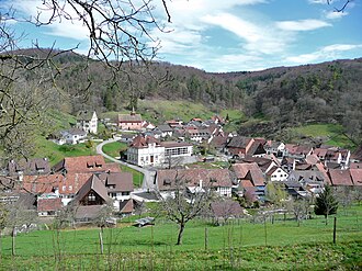
Hemmental was a municipality in the canton of Schaffhausen in Switzerland. In 2009 Hemmental merged with Schaffhausen. [1]

Contents

Hemmental was roughly 4.5 km (2.8 mi) outside of the city limits of Schaffhausen and 7 km (4.3 mi) away from the Schaffhausen train station.

Aerial view (1964) ETH-BIB-Hemmental-LBS H1-025078.tif
Aerial view (1964)

First Settlement

It is generally accepted that Hemmental was settled between the 7th and 8th centuries by the Alemans. Local tradition states that the village was named after a Germanic priest probably named Hemo. In 1090, Count Burkard of Nelleburg gave Hemmental, together with Buesingen, to the Abbey of Allerheiligen in Schaffhausen. [2]

Leu, Schlatter, Hatt and Mettler families

In the year 1483, the name "Schlatter" first appears in Hemmental, followed by those of "Mettler", "Hatt" and "Leu". These families dominated in the area. Today, there are also the four place names, Schlatter, Leuen, Hatten and Mettlerhof reflecting this influence. Three of these family names still prevail in Hemmental; the name Mettler no longer being found here. It is these four names which, in 1951, led to the resolution that a new village coat of arms be introduced - four golden stars on blue and red shield. The blazon of the municipal coat of arms is Per saltire Gules and Azure in each a Mullet Or. [3]

Geography

Hemmental had an area, as of 2006, of 10.9 km2 (4.2 sq mi). Of this area, 26.6% is used for agricultural purposes, while 70.3% is forested. The rest of the land, (3%) is settled. [4] It is a farming village at the foot of the Randen range.

Demographics

In the 2007 federal election the most popular party was the SVP which received 53.9% of the vote. The next two most popular parties were the SP (27.2%), and the FDP (18.8%). [4]

The historical population is given in the following table: [2]

yearpopulation
1771241
1798305
1836372
1850409
1900496
1950409
2000513

References

  1. Amtliches Gemeindeverzeichnis der Schweiz published by the Swiss Federal Statistical Office (in German) accessed 23 September 2009
  2. 1 2 Hemmental in German , French and Italian in the online Historical Dictionary of Switzerland .
  3. Flags of the World.com Archived 2011-06-05 at the Wayback Machine accessed 15-December-2009
  4. 1 2 Swiss Federal Statistical Office Archived 2011-09-04 at the Wayback Machine accessed 15-December-2009