The M25 or London Orbital Motorway is a major road encircling most of Greater London. The 117-mile (188-kilometre) motorway is one of the most important roads in the UK and one of the busiest. Margaret Thatcher opened the final section in 1986, making the M25 the longest ring road in Europe upon opening. The Dartford Crossing completes the orbital route but is not classed as motorway; it is classed as a trunk road and designated as the A282. In some cases, including notable legal contexts such as the Communications Act 2003, the M25 is used as a de facto alternative boundary for Greater London.
The A3, known as the Portsmouth Road or London Road in sections, is a major road connecting the City of London and Portsmouth passing close to Kingston upon Thames, Guildford, Haslemere and Petersfield. For much of its 67-mile (108 km) length, it is classified as a trunk road and therefore managed by National Highways. Almost all of the road has been built to dual carriageway standards or wider. Apart from bypass sections in London, the road travels in a southwest direction and, after Liss, south-southwest.
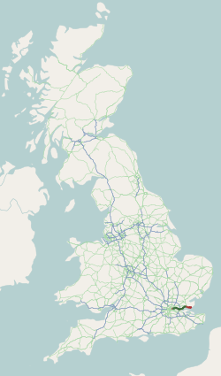
The A1 also known as the Great North Road is the longest numbered road in the United Kingdom, at 410 miles (660 km). It connects London, the capital of England, with Edinburgh, the capital of Scotland. It passes through or near north London, Hatfield, Welwyn Garden City, Stevenage, Baldock, Letchworth Garden City, Biggleswade, St Neots, Huntingdon, Peterborough, Stamford, Grantham, Newark-on-Trent, Retford, Doncaster, Pontefract, York, Wetherby, Ripon, Darlington, Durham, Sunderland, Gateshead, Newcastle upon Tyne, Morpeth, Alnwick and Berwick-upon-Tweed.

The M3 is a motorway in England, from Sunbury-on-Thames, Surrey, to Eastleigh, Hampshire; a distance of approximately 59 miles (95 km). The route includes the Aldershot Urban Area, Basingstoke, Winchester, and Southampton.

The A303 is a trunk road in southern England, running between Basingstoke in Hampshire and Honiton in Devon via Stonehenge. Connecting the M3 and the A30, it is part of one of the main routes from London to Devon and Cornwall. It is a primary A road throughout its length, passing through five counties.

The Woolwich Ferry is a free vehicle and pedestrian ferry across the River Thames in East London, connecting Woolwich on the south bank with North Woolwich on the north. It is licensed and financed by London River Services, the maritime arm of Transport for London (TfL). Around two million passengers use the ferry each year.

The M2 is a 26 mile long motorway in Kent, England, and was built to bypass a section of the A2 road in Kent, which goes through the Medway Towns, Sittingbourne, and Faversham. It provides an alternative route to the Port of Dover, which supplements the M20 motorway located further to the south. The terminal junctions of the M2 intersect with the A2, which come together to form a 62 mile long trunk road from London to Dover.

The A23 road is a major road in the United Kingdom between London and Brighton, East Sussex, England. It is managed by Transport for London for the section inside the Greater London boundary, Surrey County Council and West Sussex County Council for the section shadowed by the M23 motorway, National Highways between the M23 and Patcham, and by Brighton and Hove Council from the A27 to the centre of Brighton.

The M20 is a motorway in Kent, England. It follows on from the A20 at Swanley, meeting the M25, and continuing on to Folkestone, providing a link to the Channel Tunnel and the ports at Dover. It is 50.6 miles (81.4 km) long. Although not signposted in England, this road is part of the European route E15. It is also used as a holding area for goods traffic when traffic across the English Channel is disrupted, such as Operation Stack and Operation Brock.

The A20 is a major road in south-east England, carrying traffic from London to Dover in Kent. Parts of the route date back to turnpikes established in the early part of the 18th century. The line of the road throughout Kent runs closely in parallel with the M20 motorway.

The A12 is a major road in Eastern England. It runs north-east/south-west between London and the coastal town of Lowestoft in the north-eastern corner of Suffolk, following a similar route to the Great Eastern Main Line until Ipswich. A section of the road between Lowestoft and Great Yarmouth became part of the A47 in 2017. Between the junctions with the M25 and the A14, the A12 forms part of the unsigned Euroroute E30. Unlike most A roads, this section of the A12, together with the A14 and the A55, has junction numbers as if it were a motorway.
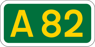
The A82 is a major road in Scotland that runs from Glasgow to Inverness via Fort William. It is one of the principal north-south routes in Scotland and is mostly a trunk road managed by Transport Scotland, who view it as an important link from the Central Belt to the Scottish Highlands and beyond. The road passes close to numerous landmarks, including Loch Lomond, Rannoch Moor, Glen Coe, the Ballachulish Bridge, Ben Nevis, the Commando Memorial, Loch Ness, and Urquhart Castle. Along with the A9 and the A90 it is one of the three major north–south trunk roads connecting the Central Belt to the North.
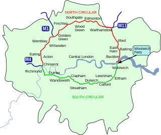
The North Circular Road is a 25.7-mile-long (41.4 km) ring road around Central London in England. It runs from Chiswick in the west to Woolwich in the east via suburban North London, connecting various suburbs and other trunk roads in the region. Together with its counterpart, the South Circular Road, it forms a ring road around central London. This ring road does not make a complete circuit of the city, being C-shaped rather than a complete loop as the crossing of the River Thames in the east is made on the Woolwich Ferry.
The South Circular Road in south London, England, is a major road that runs from the Woolwich Ferry in the east to the Chiswick Flyover in the west via Eltham, Lee Green, Catford, Forest Hill, Dulwich, Tulse Hill, Clapham Common, Clapham Junction, Wandsworth, Putney, Barnes, Mortlake and Kew Bridge. Together with the North Circular Road and Woolwich Ferry, it makes a complete ring-road around Central London and forms the boundary of the Ultra Low Emission Zone. The South Circular is largely a sequence of urban streets joined together, requiring several at-grade turns, unlike the mostly purpose-made carriageways of the North Circular. As a result, it is frequently congested.
The A13 is a major road in England linking Central London with east London and south Essex. Its route is similar to that of the London, Tilbury and Southend line via Rainham, Grays, Tilbury, Stanford-Le-Hope & Pitsea,and runs the entire length of the northern Thames Gateway area, terminating on the Thames Estuary at Shoeburyness. It is a trunk road between London and the Tilbury junction, a primary route between there and Sadlers Hall Farm near South Benfleet, and a non-primary route between there and Shoeburyness.
For other roads with the same name see List of A21 roads.

The A31 is a major trunk road in southern England that runs from Guildford in Surrey to Bere Regis in Dorset. Its most well known section is the Hog's Back, a hilly ridge forming part of the North Downs, in the Surrey stretch between Guildford and Farnham.

The A33 is a major road in the counties of Berkshire and Hampshire in southern England. The road currently runs in three disjoint sections.

The A74 also known historically as the Glasgow to Carlisle Road, is a formerly major road in the United Kingdom, linking Glasgow in Scotland to Carlisle in the North West of England, passing through Clydesdale, Annandale and the Southern Uplands. A road in this area has existed since Roman Britain, and it was considered one of the most important roads in Scotland, being used as a regular mail service route.
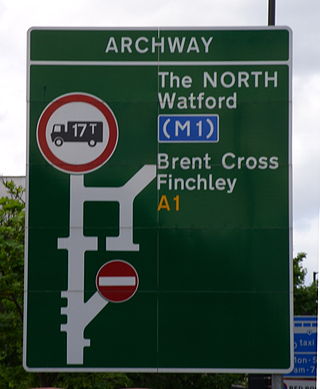
The A1 in London is the southern part of the A1 road. It starts at Aldersgate in the City of London, passing through the capital to Borehamwood on the northern fringe of Greater London, before continuing to Edinburgh. The road travels through the City and three London boroughs: Islington, Haringey and Barnet, which include the districts of Islington, Holloway, Highgate, Hendon and Mill Hill, and travels along Upper Street and Holloway Road, crossing the North Circular Road in Hendon, a district in the London Borough of Barnet.