The Board of Ordnance was a British government body. Established in the Tudor period, it had its headquarters in the Tower of London. Its primary responsibilities were 'to act as custodian of the lands, depots and forts required for the defence of the realm and its overseas possessions, and as the supplier of munitions and equipment to both the Army and the Navy'. The Board also maintained and directed the Artillery and Engineer corps, which it founded in the 18th century. By the 19th century, the Board of Ordnance was second in size only to HM Treasury among government departments. The Board lasted until 1855, at which point it was disbanded.
Major-General William Roy was a Scottish military engineer, surveyor, and antiquarian. He was an innovator who applied new scientific discoveries and newly emerging technologies to the accurate geodetic mapping of Great Britain. His masterpiece is usually referred to as Roy's Map of Scotland.
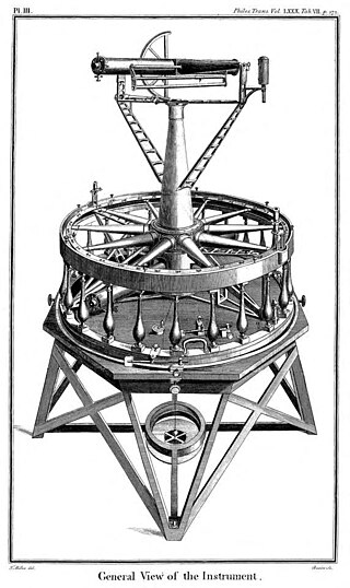
The Ramsden surveying instruments are those constructed by Jesse Ramsden and used in high precision geodetic surveys carried out in the period 1784 to 1853. This includes the five great theodolites—great in name, great in size and great in accuracy—used in surveys of Britain and other parts of the world. Ramsden also provided the equipment used in the measurement of the many base lines of these surveys and also the zenith telescope used in latitude determinations.

The Principal Triangulation of Britain was the first high-precision triangulation survey of the whole of Great Britain and Ireland, carried out between 1791 and 1853 under the auspices of the Board of Ordnance. The aim of the survey was to establish precise geographical coordinates of almost 300 significant landmarks which could be used as the fixed points of local topographic surveys from which maps could be drawn. In addition there was a purely scientific aim in providing precise data for geodetic calculations such as the determination of the length of meridian arcs and the figure of the Earth. Such a survey had been proposed by William Roy (1726–1790) on his completion of the Anglo-French Survey but it was only after his death that the Board of Ordnance initiated the trigonometric survey, motivated by military considerations in a time of a threatened French invasion. Most of the work was carried out under the direction of Isaac Dalby, William Mudge and Thomas Frederick Colby, but the final synthesis and report (1858) was the work of Alexander Ross Clarke. The survey stood the test of time for a century, until the Retriangulation of Great Britain between 1935 and 1962.

Thomas Frederick Colby FRS FRSE FGS FRGS, was a British major-general and director of the Ordnance Survey (OS). A Fellow of the Royal Astronomical Society and Royal Society, Colby was one of the leading geographers of his time.

Colonel Sir Charles Frederick Arden-Close, was a British geographer and surveyor. He was Director General of the Ordnance Survey from 1911 to 1922. His insistence on attention to detail saw the improvement of many attitudes and methods at the Ordnance Survey. Close's planning saw the production of many maps now viewed as pinnacles in the classic period of map making. He was born Charles Frederick Close and changed his surname to Arden-Close in 1938 so as to comply with a bequest.
Zincography was a planographic printing process that used zinc plates. Alois Senefelder first mentioned zinc's lithographic use as a substitute for Bavarian limestone in his 1801 English patent specifications. In 1834, Federico Lacelli patented a zincographic printing process, producing large maps called géoramas. In 1837–1842, Eugène-Florent Kaeppelin (1805–1865) perfected the process to create a large polychrome geologic map.
Photozincography, sometimes referred to as heliozincography but essentially the same process, known commercially as zinco, is the photographic process developed by Sir Henry James FRS (1803–1877) in the mid-nineteenth century.

Lieutenant Colonel William Yolland CB, FRS FRSA was an English military surveyor, astronomer and engineer, and was Britain's Chief Inspector of Railways from 1877 until his death. He was a redoubtable campaigner for railway safety, often in the face of strong opposition, at a time when railway investment was being directed towards the expansion of the networks rather than the prevention of accidents. He was a member of the three-man committee of inquiry into the Tay Bridge disaster.

Col Alexander Ross Clarke FRS FRSE (1828–1914) was a British geodesist, primarily remembered for his calculation of the Principal Triangulation of Britain (1858), the calculation of the Figure of the Earth and one of the most important text books of Geodesy (1880). He was an officer of the Royal Engineers employed on the Ordnance Survey.
Scribing was used to produce lines for cartographic map compilations before the use of computer-based geographic information systems. Lines produced by manual scribing are sharp, clear and even.

In the 1860s the first facsimile of Domesday Book was created by the process of photozincography, and was executed under the directorship of Henry James at the Southampton offices of the Ordnance Survey.

The Ordnance Survey (OS) is the national mapping agency for Great Britain. The agency's name indicates its original military purpose, which was to map Scotland in the wake of the Jacobite rising of 1745. There was also a more general and nationwide need in light of the potential threat of invasion during the Napoleonic Wars. Since 1 April 2015, the Ordnance Survey has operated as Ordnance Survey Ltd, a government-owned company, 100% in public ownership. The Ordnance Survey Board remains accountable to the Secretary of State for Science, Innovation and Technology. It was also a member of the Public Data Group.
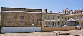
The former offices of Ordnance Survey are situated in London Road, Southampton, close to the junction with The Avenue, and are now part of the city's court complex and are occupied by government agencies. The buildings are Grade II listed.
Richard Hugh Stotherd (1828–1895) was a British Army officer, a major-general in the Royal Engineers and the director-general of the Ordnance Survey of the United Kingdom,
The Anglo-French Survey (1784–1790) was the geodetic survey to measure the relative position of the Royal Greenwich Observatory and the Paris Observatory via triangulation. The English operations, executed by William Roy, consisted of the measurements of bases at Hounslow Heath (1784) and Romney Marsh (1787), the measurements of the angles of the triangles (1787–1788) and finally the calculation of all the triangles (1788–1790). The survey is very significant as the first precise survey within Britain, and the forerunner of the work of the Ordnance Survey which was founded in 1791, one year after Roy's death.

Major General Thomas Bernard Collinson was an English military engineer of the Corps of Royal Engineers who carried out the earliest British surveys of Hong Kong, and planned roads and other early military and civil engineering works in New Zealand. Immediately prior to retirement, he was architect to the Scottish Prison Commission.

Ellis Martin (1881–1977) was an English commercial artist. For most of his working life he was employed by Britain's map making organisation the Ordnance Survey, for which he performed painting, drawing and calligraphy for their map and book covers, and for their advertisements. He was the first person to be employed by the Survey specifically as an illustrator.

The PEF Survey of Palestine was a series of surveys carried out by the Palestine Exploration Fund (PEF) between 1872 and 1877 for the completed Survey of Western Palestine and in 1880 for the soon abandoned Survey of Eastern Palestine. The survey was carried out after the success of the Ordnance Survey of Jerusalem by the newly-founded PEF, with support from the War Office. Twenty-six sheets were produced for "Western Palestine" and one sheet for "Eastern Palestine". It was the first fully scientific mapping of Palestine.

Rudolph Appel was German printer and business man who played a major role in the development of anastatic lithography, a brand name that referred to already existing transfer lithography processes, and Photozincography in United Kingdom in the mid-nineteenth century.
