Hermitage Bridge (Dunkeld, Scotland)

Last updated

Hermitage Bridge
Ossians Hall and Hermitage Bridge (geograph 2800072).jpg
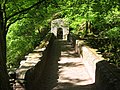
The bridge crossing the River Braan, with Ossian's Hall of Mirrors on the left, in 2012
Coordinates 56°33′27″N3°36′52″W / 56.5574352°N 3.6143987°W / 56.5574352; -3.6143987
Crosses River Braan
Locale Dunkeld, Perth and Kinross, Scotland
History
Opened1770(253 years ago) (1770)
Location
Hermitage Bridge (Dunkeld, Scotland)

The Hermitage Bridge is an ancient, single-arch stone pedestrian bridge crossing the River Braan near Dunkeld, Perth and Kinross, Scotland. A Category A listed structure, [1] it is in the bounds of The Hermitage, a National Trust for Scotland-protected site. [2] [3] The bridge should not be confused with the Rumbling Bridge, which carries motorised traffic, about 0.62 miles (1.00 km) to the southwest. [4]

Contents

The bridge was built in 1770 by order of John Murray, 3rd Duke of Atholl, presumably to gain access across to some lands leased from Sir John Stewart of Murthly, as well as assisting with the views of the Black Linn Falls. It has since become a major landscape feature and has been the subject of several paintings and sketches, including from George Washington Wilson's visit around 1859. [2]

An arch (added around 1785) [1] stands across the western entrance, while underneath its eastern end, the bridge contains a small arch giving access to the ledge below Ossian’s Hall and to a small grotto. [3]

See also

Related Research Articles

<span class="mw-page-title-main">Perthshire</span> Historic administrative division in Scotland

Perthshire, officially the County of Perth, is a historic county and registration county in central Scotland. Geographically it extends from Strathmore in the east, to the Pass of Drumochter in the north, Rannoch Moor and Ben Lui in the west, and Aberfoyle in the south; it borders the counties of Inverness-shire and Aberdeenshire to the north, Angus to the east, Fife, Kinross-shire, Clackmannanshire, Stirlingshire and Dunbartonshire to the south and Argyllshire to the west. It was a local government county from 1890 to 1930.

<span class="mw-page-title-main">Perth, Scotland</span> City in central Scotland

Perth is a city in central Scotland, on the banks of the River Tay. It is the administrative centre of Perth and Kinross council area and is the historic county town of Perthshire. It had a population of about 47,430 in 2018.

<span class="mw-page-title-main">Dunkeld Cathedral</span> Church in Perth and Kinross, Scotland

Dunkeld Cathedral is a Church of Scotland place of worship which stands on the north bank of the River Tay in Dunkeld, Perth and Kinross, Scotland. Built in square-stone style of predominantly grey sandstone, the cathedral proper was begun in 1260 and completed in 1501. It stands on the site of the former Culdee Monastery of Dunkeld, stones from which can be seen as an irregular reddish streak in the eastern gable.

<span class="mw-page-title-main">Alyth</span> Human settlement in Scotland

Alyth is a town in Perth and Kinross, Scotland, five miles northeast of Blairgowrie and about 17 miles northwest of Dundee. In 2016 the town had an estimated population of 2,400.

<span class="mw-page-title-main">Dunkeld</span> Town in Perth and Kinross, Scotland

Dunkeld is a town in Perth and Kinross, Scotland. The location of a historic cathedral, it lies on the north bank of the River Tay, opposite Birnam. Dunkeld lies close to the geological Highland Boundary Fault, and is frequently described as the "Gateway to the Highlands" due to its position on the main road and rail lines north. Dunkeld has a railway station, Dunkeld & Birnam, on the Highland Main Line, and is about 25 kilometres north of Perth on what is now the A9 road. The main road formerly ran through the town, however following modernisation of this road it now passes to the west of Dunkeld.

Muckhart commonly refers to two small villages in Clackmannanshire, Scotland, Pool of Muckhart and Yetts o' Muckhart. Muckhart is one of the Hillfoots Villages, situated on the A91 around 3 miles northeast of Dollar. The Gaelic name, Muc-àird, comes from muc ("pig") + àird ("height"), and may derive from the fact that the surrounding fields may once have been used for pig farming.

<span class="mw-page-title-main">Amulree</span> Human settlement in Scotland

Amulree is a small hamlet in Perth and Kinross, Scotland. It lies in hilly country on the A822 road, 1 km (0.62 mi) east of Loch Freuchie in Strathbraan, 8 km (5.0 mi) west of Dunkeld and 10 km (6.2 mi) north of Crieff. It lies close to the geographical centre of Scotland.

<span class="mw-page-title-main">Craigvinean Forest</span> Forest in Scotland

<span class="mw-page-title-main">The Hermitage, Dunkeld</span> National Trust for Scotland-protected forest

The Hermitage is a National Trust for Scotland-protected site in Dunkeld, Perth and Kinross. Located just to the west of the A9, it sits on the banks of the River Braan in Craigvinean Forest. It was created by John Murray, the third Duke of Atholl, who lived in nearby Dunkeld House, in the 18th century to honour the blind bard Ossian. It is home to the Georgian follies Ossian's Hall of Mirrors and Ossian's Cave. The hermit's cave was built around 1760 for the third Earl of Breadalbane, who unsuccessfully advertised for a permanent eremite. The guide in 1869, Donald Anderson, dressed up with a long beard of lichens and clothes of animal skins.

<span class="mw-page-title-main">Rumbling Bridge</span>

Rumbling Bridge is a small village built on both side of a gorge of the River Devon, which formed the boundary between the historic counties of Perthshire and Kinross-shire and is now within the combined Perth and Kinross council area, Scotland, where the A823 leaves the A977. It lies roughly 1 mile equidistant from Muckhart to its north, Crook of Devon to its east and Powmill to its south. It is named after an unusual double bridge, which gives off a distinctive rumbling reverberation at lower levels. Comprising only a few scattered houses until the mid-20th century, most property in the village dates from the 1970s onwards.

<span class="mw-page-title-main">River Braan</span> River in Scotland

The River Braan is a tributary of the River Tay in Scotland. Within the county of Perth and Kinross, it flows 11 miles (17 km) eastwards from Loch Freuchie, near Amulree, and joins the River Tay near Dunkeld.

<span class="mw-page-title-main">Ossian's Hall of Mirrors</span> View-house in Scotland

Ossian's Hall of Mirrors is a Georgian structure located at The Hermitage in Dunkeld, Scotland.

<span class="mw-page-title-main">Perth Bridge</span> Bridge in Perth, Scotland

Perth Bridge is a toll-free bridge in the city of Perth, Scotland. A Category A listed structure, it spans the River Tay, connecting Perth, on the western side of the river, to Bridgend, on its eastern side, carrying both automotive and pedestrian traffic of West Bridge Street. An earlier bridge was demolished at the same location in 1621, and many unsuccessful attempts were made to replace it. A subscription was started by James VI and several noblemen to help with the construction cost, but the king's death in 1625 suspended the scheme and a series of ferryboats were instead used.

<span class="mw-page-title-main">Falls of the Braan</span> Waterfall in Perth and Kinross, Scotland, UK

Falls of the Braan is a waterfall of Scotland located in the Hermitage at the National Trust for Scotland-protected site in Dunkeld, Perth and Kinross.

<span class="mw-page-title-main">Murthly</span> Human settlement in Scotland

Murthly is a village in Perth and Kinross, Scotland. It lies on the south bank of the River Tay, 5 miles southeast of Dunkeld, and 9+12 miles north of Perth. Perth District Asylum, later known as Murthly Hospital, was opened in the village on 1 April 1864 for 'pauper lunatics'. It was the second district asylum to be built in Scotland under the terms of the Lunacy (Scotland) Act 1857. It closed in 1984 and was later demolished. The village has a stone circle, in the former grounds of the hospital. The village formerly had a railway station on the Perth and Dunkeld Railway, which closed in 1965.

<span class="mw-page-title-main">Dunkeld Bridge</span> Bridge at Dunkeld, Perth and Kinross, Scotland

Dunkeld Bridge is a seven-arch bridge crossing the River Tay at Dunkeld, Perth and Kinross, Scotland. It carries the pedestrian and vehicle traffic of Bridge Street and connects the parishes of Dunkeld and Dowally to the north and Little Dunkeld to the south. A Category A listed structure, it is 685 feet (209 m) long, 26.5 feet (8 m) wide and 54 feet (16 m) high. Its middle arch is 90 feet (27 m) wide, two others are 84 feet (26 m), two more are 74 feet (23 m) and the land-arches are 20 feet (6 m). The pontage was abolished in 1879.

<span class="mw-page-title-main">Greyfriars Burial Ground</span> Cemetery in Perth, Scotland

Greyfriars Burial Ground is an historic cemetery in Perth, Scotland, dating to 1580. It is now Category A listed.

<span class="mw-page-title-main">Black Linn Falls</span> Waterfall in Dunkeld, Scotland

Black Linn Falls is a waterfall on the River Braan in The Hermitage, Dunkeld, Scotland. After the falls, the river passes beneath the Hermitage Bridge into a plunge pool.

<span class="mw-page-title-main">Tummel Bridge</span> Bridge at Loch Tummel, Perth and Kinross, Scotland

Tummel Bridge is a double arched hump-backed former military bridge crossing the River Tummel near Dull, Perth and Kinross, Scotland. A Category A listed structure dating to 1730, it is now pedestrian-only. It stands immediately to the southeast of a modern road bridge, which carries the vehicular traffic of today's B846 road. Two worn milestones are at the northern end of the bridge.

References