Royston is a town and civil parish in the District of North Hertfordshire and county of Hertfordshire in England.

Hitchin is a market town in the North Hertfordshire district of Hertfordshire, England. The town dates from at least the 7th century. It lies in the valley of the River Hiz at the north-eastern end of the Chiltern Hills. It is 16 miles (26 km) north-west of the county town of Hertford, and 35 miles (56 km) north of London. The population at the 2021 census was 35,220.

Hertford is the county town of Hertfordshire, England, and is also a civil parish in the East Hertfordshire district of the county. The parish had a population of 26,783 at the 2011 census.

Cheshunt is a town in the Borough of Broxbourne in Hertfordshire, England, 13 miles (21 km) north of Central London on the River Lea and Lee Navigation and directly south of Broxbourne. It contains a section of the Lee Valley Park, including much of the River Lee Country Park. To the north lies Broxbourne and Wormley, Waltham Abbey to the east, Waltham Cross and Enfield to the south, and Cuffley to the west.

Ware is a town and civil parish in the East Hertfordshire district, in the county of Hertfordshire, England. It is close to the county town of Hertford. In 2011 the parish had a population of 18,799.
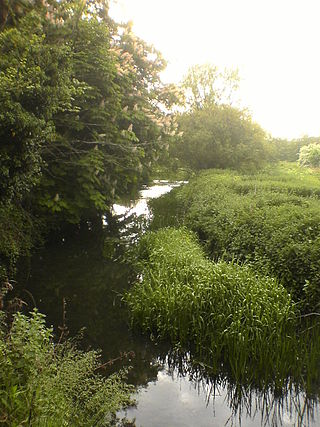
The River Rib is a tributary of the River Lea, which runs from Buckland in Hertfordshire, England. It flows into the River Lea to the east of Hertford.

Melbourn is a large, clustered village in the far south-west of Cambridgeshire, England. Its traditional high street is bypassed by the A10, intersecting the settlement's other main axis exactly 3 miles (4.8 km) northwest of the traditional focal point of Royston, Hertfordshire, the nearest larger settlement. It has over 4,600 inhabitants and is in the South Cambridgeshire district.
Waltham Cross is a town in the Borough of Broxbourne, Hertfordshire, England, located 12 miles (19 km) north of central London. In the south-eastern corner of Hertfordshire, it borders Cheshunt to the north, Waltham Abbey to the east, and Enfield to the south.

Broxbourne is a town in the Borough of Broxbourne in Hertfordshire, England, with a population of 15,303 at the 2011 Census. It is located to the south of Hoddesdon and to the north of Cheshunt, 17 miles (27 km) north of London. The town is near the River Lea, which forms the boundary with Essex, and 5 miles (8.0 km) north of the M25 motorway. To the west of the town are Broxbourne Woods, a national nature reserve. The Prime Meridian runs just east of Broxbourne.

Tonwell is a small village in Bengeo Rural parish, Hertfordshire.
The A602 is a road linking Hitchin in Hertfordshire, England, with A10 at Ware in Hertfordshire, via Stevenage.

Lambourne is a civil parish in the Epping Forest district of Essex, England. It is located approximately 4.5 miles (7 km) south of Epping and 5 miles (8 km) northwest of Romford. It covers an area of 2,590 acres (1,050 ha), and in 2001 its population was 1,828, increasing to 2,013 at the 2011 Census.

Wadesmill is a hamlet in Hertfordshire, England, located on the north side of the River Rib, with an estimated population of 264. At the 2011 Census the population of the hamlet was included in the civil parish of Thundridge. Running through the centre of Wadesmill is the road formerly known as the A10 but now that the A10 by-pass has been built, Wadesmill and surrounding villages have returned to the quiet of former times. The route that was formerly the A10 is an ancient one, with portions of it following the line of the Roman road, Ermine Street. Ermine Street also figures as the former main street in Wadesmill's adjacent village Thundridge.
High Wych is a village and civil parish in the East Hertfordshire district of Hertfordshire, England. The village is located a little over one mile south-west of the town of Sawbridgeworth, and around three miles north-east of Harlow in the neighbouring county of Essex.

Wareside is a small village and civil parish in the East Hertfordshire district, in the county of Hertfordshire, England. The population of the civil parish in the 2011 census was 735. It is approximately 3 miles (5 km) away from the town of Ware and the larger town of Hertford, the county town. Nearby villages include Widford, Hunsdon, Babbs Green and Bakers End. Nearby hamlets include Cold Christmas and Helham Green. The B1004 road linking Ware to Bishop's Stortford goes through the village and the main A10 road can be joined up at Thundridge. Fanhams Hall Road links Wareside back to Ware. Ware railway station on the Hertford East Branch Line is located two and a half miles (4 km) away.

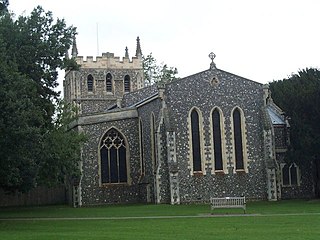
Thundridge is a village and civil parish in the East Hertfordshire district, in the county of Hertfordshire, England.

Gilston is a village and civil parish in the East Hertfordshire district of Hertfordshire, England. It is located a little over one mile north of the town of Harlow in the neighbouring county of Essex. Together with the nearby village of Eastwick, it forms the parish council of Eastwick and Gilston Parish Council. It is within the Hunsdon ward of East Hertfordshire District Council. At the 2001 Census, the population was 180, and 228 at the 2011 Census.

The Hundred Parishes is an area of the East of England with no formal recognition or status, albeit that the concept has the blessing of county and district authorities. It encompasses around 450 square miles of northwest Essex, northeast Hertfordshire and southern Cambridgeshire. The area comprises just over 100 administrative parishes, hence its name. It contains over 6,000 listed buildings and many conservation areas, village greens, ancient hedgerows, protected features and a historical pattern of small rural settlements in close proximity to one another.

Colliers End is a village in the civil parish of Standon, in the East Hertfordshire district, in Hertfordshire, England. It lies upon what was the A10, however the A10 Wadesmill by-pass has now been built around Colliers End and neighbouring villages. What was the A10 that used to run through Colliers End and the neighbouring settlements were once part of the Roman road, Ermine Street. It is 1.9 miles (3.1km) away from Standon and 5.7 miles (9.2km) away from the county town of Hertford. The population was 415 as of the 2011 census.

Cold Christmas is a small hamlet in the civil parish of Thundridge, in the East Hertfordshire district, in the county of Hertfordshire, England. It is near to the South bank of the River Rib which flows in the valley below towards Wadesmill. The name "Cold Christmas" may have come from a number of supposed deaths around Christmas time. Cold Christmas has been noted for its unusual place name.


