
Longdendale is a valley in the Peak District of England, north of Glossop and southwest of Holmfirth. The name means "long wooded valley" and the valley is mostly in the counties of Derbyshire and Greater Manchester.

The River Etherow is a river in northern England, and a tributary of the River Goyt. Although now passing through South Yorkshire, Derbyshire and Greater Manchester, it historically formed the ancient county boundary between Cheshire and Derbyshire. The upper valley is known as Longdendale. The river has a watershed of approximately 30 square miles (78 km2), and the area an annual rainfall of 52.5 inches (1,330 mm).

The River Tame flows through Greater Manchester, England. It rises on Denshaw Moor and flows to Stockport where it joins the River Goyt to form the River Mersey.

Hadfield is a village in the High Peak of Derbyshire, England. The population of the town's wards in the 2011 Census was 6,305. It lies on the south side of the River Etherow, the border between Derbyshire and Greater Manchester, at the western edge of the Peak District close to Glossop.

Woodhead is a small and scattered settlement at the head of the Longdendale valley in Derbyshire, England. It lies on the trans-Pennine A628 road connecting Greater Manchester and South Yorkshire, 6 miles (10 km) north of Glossop, 19 miles (31 km) east of Manchester and 18 miles (29 km) west of Barnsley. It is close to the River Etherow and the Trans Pennine Trail. Like nearby Tintwistle and Crowden, the hamlet lay within the historic (pre-1974) county boundaries of Cheshire.
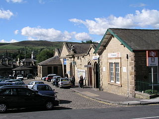
Glossop railway station serves the Pennine market town of Glossop in Derbyshire, England. Glossop is the third busiest railway station in the county of Derbyshire after Derby and Chesterfield. It is estimated 901,000 people used the station in 2016/17.

Harridge Pike is a hill situated within the boundaries of Stalybridge, Greater Manchester just outside the Peak District National Park. Its western flank rises from the valley of the River Tame to a height of 395 metres. To the east, the pike falls away more gradually to Swineshaw Moor which, above the Swineshaw reservoirs, rises to Irontongue Hill, a broad shoulder of Hoarstone Edge. Since 2004, the moorland in the area of the pike has been classed as access land. From the summit of Harridge Pike, a view is afforded of the middle section of the Tame valley and the whole of the town of Stalybridge, large swathes of the eastern suburbs of Manchester and beyond to Manchester city centre, where its town hall is visible. On exceptionally clear days the mountains of Snowdonia are visible.

Black Chew Head in Saddleworth in the Metropolitan Borough of Oldham is the highest point or county top of Greater Manchester in northern England. It stands on moorland on the edge of the Peak District at a height of 542 metres (1,778 ft) above sea level, close to the border with the High Peak district of Derbyshire.
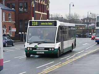
Speedwellbus was a bus operator based in Hyde, Greater Manchester, England. It operated a fleet of 25 buses on commercial and contracted services. Formed in 2002, it ceased operating rather abruptly and unexpectedly in January 2012 due to financial problems and nearly having had its licence revoked.
For the reservoirs near Stalybridge, in Tameside, Greater Manchester, see Higher Swineshaw Reservoir and Lower Swineshaw Reservoir
Hurst Reservoir was a disused reservoir near Glossop, north Derbyshire. In 1837, 50 local millowners and gentlemen, known as the "Glossop Commissioners", obtained an Act of Parliament to construct the Glossop Reservoirs. Hurst Reservoir was on the Hurst Brook and Mossy Lea Reservoir was to take water from the Shelf Brook. Only the Hurst Reservoir was constructed before the money ran out. Mossy Lea Reservoir was later constructed privately by the Duke of Norfolk. His engineer and surveyor was John Frederick Bateman. The reservoir was taken over in 1929 by the Glossop Corporation Waterworks. This became part of the Manchester Corporation Waterworks in 1959.
Mossy Lea Reservoir is a disused reservoir near Glossop, north Derbyshire. In 1837, 50 local millowners and gentlemen, known as the "Glossop Commissioners", obtained an Act of Parliament to construct the Glossop Reservoirs. Hurst Reservoir was on the Hurst Brook and Mossy Lea Reservoir was to take water from the Shelf Brook. Only the Hurst Reservoir was constructed before the money ran out. Mossy Lea Reservoir was constructed privately in 1840 by the Duke of Norfolk. It was taken over in 1929 by the Glossop Corporation Waterworks. This became part of the Manchester Corporation Waterworks in 1959. Swineshaw Reservoir, Hurst Reservoir and Mossy Lea Reservoir are no longer in service.
Healthcare in Derbyshire is now the responsibility of five clinical commissioning groups covering North Derbyshire, Southern Derbyshire, Erewash, Hardwick, and Tameside and Glossop. North Derbyshire, Southern Derbyshire, Erewash and Hardwick announced in November 2018 that they planned to merge.

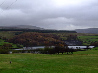
Walkerwood Reservoir is the lowest reservoir of a series of four in the Brushes valley above Stalybridge in Greater Manchester, built in the 19th century to provide a supply of safe drinking water. It is owned and operated by United Utilities. The reservoir dam consists of a clay core within an earth embankment. The embankment was originally protected from erosion with stone pitching. At a later stage these were overlain with in-situ concrete slabs, which in turn have deteriorated over the years.

Brushes Reservoir is the second lowest reservoir of a series of four in the Brushes valley above Stalybridge in Greater Manchester. It was built in the 19th century to provide a supply of safe drinking water. It is owned and operated by United Utilities. The reservoir dam consists of a clay core within an earth embankment.

Lower Swineshaw Reservoir is the second reservoir from the top of a series of four in the Brushes valley above Stalybridge in Greater Manchester. It was built in the 19th century to provide a supply of safe drinking water. It is owned and operated by United Utilities. The reservoir dam consists of a clay core within an earth embankment.

The Peak District Boundary Walk is a circular 190-mile (310 km) walking trail, starting and finishing at Buxton and broadly following the boundary of the Peak District, Britain's first national park. The route was developed by the Friends of the Peak District and was launched on 17 June 2017.

