
Glossop is a market town in the Borough of High Peak, Derbyshire, England. It is located 15 miles (24 km) east of Manchester, 24 miles (39 km) north-west of Sheffield and 32 miles (51 km) north of the county town, Matlock. Glossop lies near Derbyshire's borders with Cheshire, Greater Manchester, South Yorkshire and West Yorkshire. It is between 150 and 300 metres above sea level and is bounded by the Peak District National Park to the south, east and north.

Longdendale is a valley in the Peak District of England, north of Glossop and southwest of Holmfirth. The name means "long wooded valley" and the valley is mostly in the counties of Derbyshire and Greater Manchester.

The Derwent is a river in Derbyshire, England. It is 50 miles (80 km) long and is a tributary of the River Trent, which it joins south of Derby. Throughout its course, the river mostly flows through the Peak District and its foothills.

The River Etherow is a river in northern England, and a tributary of the River Goyt. Although now passing through South Yorkshire, Derbyshire and Greater Manchester, it historically formed the ancient county boundary between Cheshire and Derbyshire. The upper valley is known as Longdendale. The river has a watershed of approximately 30 square miles (78 km2), and the area an annual rainfall of 52.5 inches (1,330 mm).
Dovestone Reservoir lies at the convergence of the valleys of the Greenfield and Chew Brooks above the village of Greenfield, on Saddleworth Moor in Greater Manchester, England. The reservoir is on the western edge of the Peak District National Park. It supplies drinking water to the surrounding area and is a tourist attraction, providing several walks amongst picturesque landscapes.

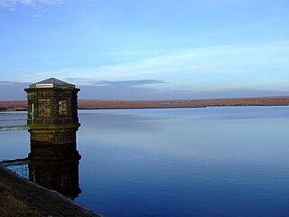
Damflask Reservoir is situated at grid reference SK277907 five miles west of the centre of Sheffield in the Loxley valley close to the village of Low Bradfield and within the city's boundaries. The hamlet of Stacey Bank is located to the east. The reservoir has a capacity of 4,250.9 million litres and has a surface area of 47 hectares with a maximum depth of 27 metres. The dam wall is approximately 400 metres wide with a height of 28 metres.

Chew Valley in Saddleworth, Greater Manchester, England, follows the course of Chew Brook on the western slopes of Black Chew Head to where it joins the River Tame at Greenfield, east of Manchester. Part of the higher fringes of the valley towards the peak of Black Chew Head lie across the boundary in Derbyshire. The eastern part of the valley including the reservoirs of Dovestone and Chew are within the north western extremity of the Peak District National Park.
Chew Reservoir is a reservoir at the head of the Chew Valley in the Peak District National Park in Greater Manchester, England.
Woodhead reservoir is a man-made lake near the hamlet of Woodhead in Longdendale in north Derbyshire, England. It was constructed by John Frederick Bateman between 1847 and June 1877 as part of the Longdendale Chain of reservoirs to supply water from the River Etherow to the urban areas of Greater Manchester. It is at the top of the chain of reservoirs and was the first to be started, though, due to construction problems, it was the last to be completed.

Arnfield Reservoir is a man-made lake in Longdendale in north Derbyshire, England. It was constructed in 1854 as part of the Longdendale chain to supply water from the River Etherow to the urban areas of Greater Manchester. Unlike the other reservoirs in the chain, Arnfield and Hollingworth Reservoir are not in the Etherow valley but lie in the valley of tributary brooks to the north and above. From Arnfield the water is extracted to pass through the Mottram Tunnel to Godley.
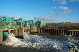
The Lee Flood Relief Channel (FRC) is located in the Lea Valley and flows between Ware, Hertfordshire, and Stratford, east London. Work started on the channel in 1947 following major flooding and it was fully operational by 1976. The channel incorporates existing watercourses, lakes, and new channels. Water from the channel feeds the Lee Valley Reservoir Chain.

Hurst Reservoir is a former, now disused, reservoir near Glossop, north Derbyshire.

Mossy Lea Reservoir is a disused reservoir near Glossop, north Derbyshire. In 1837, 50 local millowners and gentlemen, known as the "Glossop Commissioners", obtained an Act of Parliament to construct the Glossop Reservoirs. Hurst Reservoir was on the Hurst Brook and Mossy Lea Reservoir was to take water from the Shelf Brook. Only the Hurst Reservoir was constructed before the money ran out. Mossy Lea Reservoir was constructed privately in 1840 by the Duke of Norfolk. It was taken over in 1929 by the Glossop Corporation Waterworks. This became part of the Manchester Corporation Waterworks in 1959. Swineshaw Reservoir, Hurst Reservoir and Mossy Lea Reservoir are no longer in service.

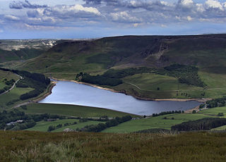
Greenfield Reservoir is a reservoir in the Saddleworth parish of the Metropolitan Borough of Oldham in Greater Manchester, in the English Peak District. Lying within the historic boundaries of the West Riding of Yorkshire, above the village of Greenfield, it is on the edge of the Peak District National Park, near the A635 road on Saddleworth Moor. The reservoir is fed by the Greenfield Brook and is above the Yeoman Hey Reservoir, which in turn feeds into Dovestone Reservoir.
For the reservoirs near Glossop, in Derbyshire, see Upper Swineshaw Reservoir and Swineshaw Reservoir (Derbyshire)

The Peak District Boundary Walk is a circular 190-mile (310 km) walking trail, starting and finishing at Buxton and broadly following the boundary of the Peak District, Britain's first national park. The route was developed by the Friends of the Peak District and was launched on 17 June 2017.

Fernilee Reservoir is a drinking-water reservoir fed by the River Goyt in the Peak District National Park, within the county of Derbyshire and very close to the boundary with Cheshire. The village of Fernliee sits at the north end of the reservoir, with Goyt's Moss to the south and between Hoo Moor to the west and Combs Moss to the east.

Wessenden Reservoir is the second in a series of four reservoirs in the Wessenden Valley above the village of Marsden in West Yorkshire, at the northern end of the Peak District National Park.

