U.S. Route 281 (US 281) is a north–south United States Numbered Highway. At 1,875 miles (3,018 km) it is the longest continuous three-digit U.S. Route.

U.S. Route 59 is a north–south United States highway. A latecomer to the U.S. numbered route system, US 59 is now a border-to-border route, part of the NAFTA Corridor Highway System. It parallels U.S. Route 75 for nearly its entire route, never much more than 100 miles (160 km) away, until it veers southwest in Houston, Texas. Its number is out of place since US 59 is either concurrent with or entirely west of U.S. Route 71. The highway's northern terminus is 9 mi (14 km) north of Lancaster, Minnesota, at the Lancaster–Tolstoi Border Crossing on the Canada–US border, where it continues as Manitoba Highway 59. Its southern terminus is at the Mexico–US border in Laredo, Texas, where it continues as Mexican Federal Highway 85D.

The Monaro Highway is a highway in Victoria, New South Wales, and the Australian Capital Territory, in Australia.
Highway 6 is a two-lane highway passing between the Kootenay and Okanagan regions in the province of British Columbia, Canada. It is divided into two parts—the Nelson-Nelway Highway between the Canada–US border and Nelson, and the Vernon-Slocan Highway between South Slocan and Vernon. Highway 6 is a north–south highway between Nelway and the Needles Ferry and an east–west highway between the Needles Ferry and Vernon; it has a total length of 407 km (253 mi). It first opened in 1941, and its very winding path through the western Kootenays has not changed since.
King's Highway 101, commonly referred to as Highway 101, is a provincially maintained highway in the Canadian province of Ontario. The 473.3-kilometre (294.1 mi) highway connects Highway 17 west of Wawa with Highway 11 in Matheson before continuing east to the Ontario–Quebec border where it becomes Route 388. The highway forms one of the only connections between the two routes of the Trans-Canada Highway between Nipigon and Temagami, and crosses some of the most remote regions of Northern Ontario. Major junctions are located with Highway 129 near Chapleau and Highway 144 southwest of Timmins, though the distance between these junctions is significant.
Emerson is an unincorporated community recognized as a local urban district in south central Manitoba, Canada, located within the Municipality of Emerson – Franklin. It has a population of 678 as of the 2016 Canada census.

Highway 17 is a highway in Canada that straddles and criss-crosses the Alberta–Saskatchewan provincial border. The portion from the provincial border at Dillberry Lake Provincial Park to the provincial border 800 metres (2,600 ft) north of the North Saskatchewan River is designated as Alberta Provincial Highway No. 17 by Alberta Transportation, commonly referred to as Highway 17.

The North–South–East–West Corridor (NS-EW) is the largest ongoing highway project in India. It is the second phase of the National Highways Development Project (NHDP), and consists of building 7300 kilometers of four/six lane highways associating Srinagar, Kanyakumari, Kochi, Porbandar and Silchar, at a cost of US$12.317 billion. As of 31 March 2018, 6875 of the 7142 kilometers project has been finished.
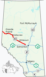
Alberta Provincial Highway No. 43, commonly referred to as Highway 43, is a major highway in northern and central Alberta, Canada that connects Edmonton to the British Columbia border via the Peace Country, forming the northernmost portion of the CANAMEX Corridor in Alberta. It stretches approximately 495 km (308 mi) from Highway 16 near Manly Corner west of Edmonton to the British Columbia border west of Demmitt. It is designated as a core route in Canada's National Highway System, comprising a portion of a key international corridor that stretches from Alaska into Mexico.
Provincial Trunk Highway 5 is a provincial primary highway located in the Canadian province of Manitoba.
Highway 14 is a highway in the Canadian province of Saskatchewan. It runs from the Alberta border where it becomes Highway 13 to intersection of Circle Drive and 22nd Street in Saskatoon. It is approximately 250 km (160 mi) long.

Highway 18 is a highway in the Canadian province of Saskatchewan. It runs from Highway 13 near Robsart, approximately 65 km (40 mi) east of the Alberta border, to the Manitoba border near Gainsborough, where it becomes Highway 3. It passes through three major communities, all in the eastern quarter of Saskatchewan – Estevan, Oxbow, and Carnduff; it also passes north of the west and east blocks of Grasslands National Park. Highway 18 is about 712 km (442 mi) long, which is the longest east-west highway and second longest highway in Saskatchewan.

U.S. Highway 59 (US 59) in the U.S. state of Texas is named the Lloyd Bentsen Highway, after Lloyd Bentsen, former U.S. senator from Texas. In northern Houston, US 59, co-signed with Interstate 69 (I-69), is the Eastex Freeway. To the south, which is also co-signed with I-69, it is the Southwest Freeway. The stretch of the Southwest Freeway just west of The Loop was formerly one of the busiest freeways in North America, with a peak AADT of 371,000 in 1998.
Highway 48 is a highway in the Canadian province of Saskatchewan. It runs from Highway 1 at White City, about 10 km (6 mi) east of Regina, to the Manitoba–Saskatchewan border, where it becomes Provincial Road 257. Highway 48 is about 238 km (148 mi) long.
Aisy-sous-Thil is a commune in the Côte-d'Or department in the Bourgogne-Franche-Comté region of eastern France.
Interstate 90 (I-90) is an east–west transcontinental Interstate highway across the northern United States, linking Seattle to Boston. The portion in the state of Montana is 554.10 miles (891.74 km) in length, passing through fourteen counties in central and southern Montana. Due to the large size of Montana, it is the longest segment of Interstate 90 within a single state.

Mahendra Highway, also called East-West Highway runs across the Terai geographical region of Nepal, from Mechinagar in the east to Bhim Datta in the west, cutting across the entire width of the country. It is the longest highway in Nepal and was constructed by cooperation of various countries. The highway runs through all the provinces of Nepal except Karnali Province.
Arunachal Frontier Highway, also Mago-Thingbu–Vijaynagar Border Highway, is a planned border highway in the Indian state of Arunachal Pradesh. The 2,000-kilometre-long (1,200 mi) road follows the McMahon Line, the international border between India and China. The Government of India estimates the cost at ₹40,000 crore.

National Highway 5 (NH5), is a primary national highway in India, running from West to East, connecting Firozpur in Punjab to the Sino-Indian border at Shipki La. The highway passes through Moga, Jagraon, Ludhiana, Mohali, Chandigarh, Panchkula, Kalka, Solan, Shimla, Theog, Narkanda, Kumarsain, Rampur Bushahr and continues along the Sutlej River till its terminus near the Tibet border.
National Highway 10 is a national highway in North East India that connects Indo/Bangladesh border via Siliguri to Gangtok. It passes through the Indian states of West Bengal and Sikkim.

